
 | ||
Khor virap and kevork chavush ararat plain armenia september 2009
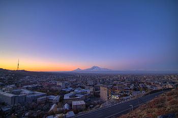
The Ararat plain (Armenian: Արարատյան դաշտ Araratyan dašt) is one of the largest of the Armenian Plateau. It stretches west of the Sevan basin, at the foothills of the Geghama mountains. In the north, the plain borders on Mount Aragats, and Mount Ararat in the south. It is divided into two sections by the Aras River, the northern part located in Armenia, and the southern part in Turkey.
Contents
- Khor virap and kevork chavush ararat plain armenia september 2009
- EtymologyEdit
- ClimateEdit
- AgricultureEdit
- ArchaeologyEdit
- References
EtymologyEdit
The Medieval Armenian historian Moses of Khoren recorded in his History of Armenia that the Ararat plain was named after King Ara the Handsome, the great-grandson of Amasya.
ClimateEdit
The Ararat plain and the Sevan basin experience abundant sunshine and are the sunniest areas in Armenia, receiving about 2,700 hours of sunshine a year. The shortest duration of sunshine is in mid-mountain areas of the forest zone (about 2,000 hours). In the foothills, there is rarely a sunless day between the months of June and October.
AgricultureEdit
The Ararat plain makes up 4% of Armenia's total land area, and yet it yields 40% of Armenia's farm production.
ArchaeologyEdit
This area has been occupied since the Neolithic or the Early Chalcolithic times.
At Aratashen, first pottery appears at the end of the fifth millennium BC, or before 4000 BC.