
Population 2,483 (2011 census) Postal code 2614 Federal division Division of Fenner | Postcode(s) 2614 Area 160 ha Gazetted 22 June 1967 | |
 | ||
Aranda is a suburb in the district of Belconnen, in the Australian capital city of Canberra. Located at the western foot of Black Mountain and bounded on two sides by nature park, the suburb is characterised by its bush setting. During the planning and development of the suburb, a large proportion of large native trees – predominantly eucalypts – were left in place.
Contents
- Map of Aranda ACT 2614 Australia
- Location
- Transport
- Facilities
- Community activity
- Political representation
- Geology
- References
Map of Aranda ACT 2614, Australia
The suburb derives its name from the Arrernte tribe of Central Australia, previously known as Arunta, which means 'White Cockatoo'. The streets in Aranda are named after Aboriginal tribal groups from around Australia. The suburb comprises an area of 160ha and in 1967 was the first suburb in Belconnen to be settled.
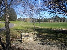
A small plaque at the Aranda District playing fields near the suspension bridge over Belconnen Way marks the settlement of the suburb as the first development in the Belconnen district. It reads:
"This tablet marks the inauguration of development of the district of Belconnen by the Minister of State for the Interior The Honourable J. D. Anthony, M.P. 23 June 1966"Location
Aranda is located in the south east of Belconnen. It is bounded by Caswell Drive on the east, separating the suburb from Black Mountain Nature Park, Belconnen Way to the north, Bindubi Street to the west and Aranda Bushland to the south. A pedestrian bridge crossing the six-lane Belconnen Way connects the suburb with the suburb of Bruce to the north. The suburbs of Cook and Macquarie are located to Aranda’s west on the opposite side of Bindubi Street.
Aranda is located 4 km to the west of Civic along Belconnen Way. Bandjalong Crescent, a curved bell shaped street is the main street passing through the suburb, connecting Caswell Drive with Bindubi Street. A number of community facilities are located in the centre of the curve.
Transport
A bicycle path along Bindubi Street connects Aranda with the Canberra bike path network. A walking path runs through a reserve along the spine of the suburb and connects with the footbridge to the suburb of Bruce. A walking track over Black Mountain connects Aranda with the CSIRO and the Australian National University.
Aranda is served by buses which connect Civic with Belconnen Town Centre via Cook and Macquarie. Buses to Belconnen also stop on Belconnen Way and at the Calvary Hospital located in Bruce without passing through the suburb.
Facilities
A number of community facilities are located close to one another near the intersections of Bandjalong and Bindel Streets. These include two primary schools (Aranda Primary Schoo] and St. Vincent's Catholic school), two churches and a pre-school.
Aranda has a local set of shops. The Aranda shops were left vacant for many years but have recently been leased and are under renovation. A cafe has opened, with outdoor seating, and there are plans for a bakery and pizzeria in 2015. The nearby Jamison Centre in neighbouring Macquarie services the area on a much larger scale, including supermarkets, retail and medical outlets, banks and cafes.
A number of playing fields are located in the north western corner of the suburb including baseball and soccer fields, as is a Scout hall. A nursing home was located on Bindel Street, but it closed in 2015.
Community activity
Due to its setting in a bush environment and the interest expressed by its residents, Canberra’s first Community Fire Unit was established in Aranda in 2003 [1]. The programme provides Aranda residents with training and fire fighting equipment to fight bushfires in their suburb.
The Friends of Aranda Bushland group is active in the suburb.
The Aranda Residents Group (ARG) is active in representing the interests of its residents on such major planning issues as the Gungahlin Drive Extension,* proposed ‘A10’ planning reforms,* the Emergency Services Station on Aranda Oval (opened 2016), and redevelopment of the Aranda Shops.
Political representation
For the purposes of Australian federal elections for the House of Representatives, Aranda is in the Fenner.
For the purposes of Australian Capital Territory elections for the ACT Legislative Assembly, Aranda is in the Ginninderra electorate.
Geology
Aranda is built on top of rocks from the Pittman Formation. These are from the upper Ordovician Age. Mostly the rocks are greywacke formed on a continental slope, but also have bands of the Acton Shale Member, a grey to black laminated shale. The Acton Shale contains graptolites. The Deakin Fault cuts through the south west of the Aranda Bushland. South west of the fault is Silurian age Mount Painter Volcanics tuff and ashstone.