
Length 173 km Basin area 2,940 km² Bridges Kiyosuna Bridge | Discharge 30 m³/s Country Japan | |
 | ||
Similar Tokyo Bay, Iwabuchi Watergate, Akigase Park, Kita‑Senju Station, Kasai Rinkai Park | ||
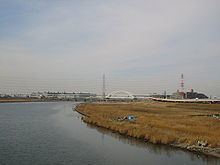
The Arakawa River (荒川, Arakawa), also known as the Ara River, is a 173-kilometre (107 mi) long river that flows through Saitama Prefecture and Tokyo.
Contents
Map of Arakawa River, Japan
It originates on Mount Kobushi in Saitama Prefecture, and empties into Tokyo Bay. It has a total catchment area of 2940km2.
History
Attempts to control flooding of the Arakawa River have been made since the area that is now Tokyo became the de facto capital of Japan during the Edo period. Following a major flood in 1910 that damaged a large part of central Tokyo, a 22km-long drainage canal was constructed between 1911 and 1924. In 1996 an agreement was signed to make it a "sister river" of the Potomac River in the eastern United States.
References
Arakawa River (Kanto) Wikipedia(Text) CC BY-SA