
Country Brazil Time zone UTC-3 (UTC-3) Elevation 1,013 m Local time Monday 11:38 PM | Founded 1888 Website Araguari Area 2,731 km² Population 106,403 (2007) | |
 | ||
Weather 20°C, Wind NE at 6 km/h, 90% Humidity | ||
Mauro imoveis balan a araguari bom dia araguari com letra
Araguari is a municipality in western Minas Gerais state, Brazil. It is located in the northern Triângulo Mineiro region, on the Jordão River, a tributary of the Paranaíba River, at an elevation between 940 and 1,087 meters. The municipality of Araguari has an area of 2,774 km², with 54 km² in the urban zone and 2,675 km² in the rural zone. The population in 2011 was 110,402, making it the third most important city in the Triângulo Mineiro, after Uberlândia and Uberaba. Araguari has also been one of the fastest growing cities in Brazil, growing more than the rest of the country in proportion.
Contents
- Mauro imoveis balan a araguari bom dia araguari com letra
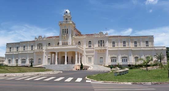
- Map of Araguari State of Minas Gerais Brazil
- Rivers
- Climate
- Distances from major cities
- Main highways serving the municipality
- Demographics
- The economy
- Health and education
- Culture
- Tourism
- History
- References
Map of Araguari, State of Minas Gerais, Brazil
Rivers
Rivers that water the municipality are: Rio Araguari, Ribeirão das Araras, Corrego Grande, Ribeirão Jordão, and Ribeirão Piçarrão. The Paranaíba in the north forms the boundary with the state of Goiás. There are many waterfalls and rapids (128 according to one source) giving the area a great potential in tourism.
Climate
The year is divided into two periods, the rainy season from November to April and the dry season from May to October. Because of the elevation (more than 1,000 meters above sea level) temperatures are pleasant with few extremes although humidity can be high in the rainy season.
Distances from major cities
Main highways serving the municipality
Araguari is a major railroad junction and connects with the states of Goiás, Tocantins, and Mato Grosso do Sul.
Demographics
The economy
Araguari's main source of income is from the large herds of cattle raised in the hinterlands, where rice, soybeans, corn (maize), citrus fruits, tomatoes, beans, and manioc are also cultivated. In recent years the region has become one of the most important coffee-growing areas in the country and there is an annual coffee fair. Araguari has 9 financial institutions. There is an industrial park with several industries specializing in metallurgy, agro-industrial products (cold meats and juices) and storage facilities for grains. In the last feww years Araguari has been changing rapidly and receiving many important investments as Selecta which produces soy bean oils and accounts more than 500 new jobs. The city also received the biggest rail trainshipment in Latin America. Now Araguari is lacking of workers to work in the many new jobs offers.
Occupation of the population by sectors
Enterprises
Farm data for 2006 Most of the rural properties have between 01 and 50 hectares. If we add to this group those properties between 51 and 100 hectares then we reach 72% of the total.
Main permanent crops in planted area in 2006
Main perennial crops in planted area in 2006
Livestock raising in 2006
Health and education
Culture
There is a theater with capacity to seat 120 persons. The sports center seats 5,000 spectators. In the urban area there is a tropical forest, the Bosque John Kennedy, with an area of 112,000 square meters. There is a movie theater "Cinema Odete" and also a public theater located in the city center "Cine Teatro".
Tourism
On the northern boundary of the municipality is an immense complex of hydroelectric power stations (Emborcação and Miranda), which form several lakes. In addition to the energy supplied these are great tourist attractions, providing opportunities for fishing and the practice of water sports. [1] and [2] And two more are being built (Capim Branco I and II)
History
Settlement began in the first decades of the nineteenth century. Brejo Alegre was the name of the small village (arraial) composed of some buildings, among them a small chapel, simple houses, a few stores, and a lot of cattle ranches. In 1843 the village was raised to the status of district with the name of Sant’Ana do Rio das Velhas.
In 1882 the district was declared a "vila" (town) and in 1888 it was raised to the category of "cidade" or city, with the new name of Araguari. At this time the town consisted of the Igreja Matriz (Main church) of Senhor Bom Jesus da Cana Verde with its colonial style; the cemetery located behind the church; the houses with tiles but no ceilings, called casas de “telhas ao vento”; and in the center flowed a stream dividing the settlement, one part called Goiás, and the other, Minas. The small commerce consisted of a bakery, a shoe store, two pharmacies and some general stores, called “vendas”.
The great change in the town's situation occurred with the arrival of the railroad, the Cia. Mogiana de Estrada de Ferro, in 1896. In 1906 this railroad, called Estrada de Ferro Goiás, was extended to Goiás, further increasing the growth of the city.