
Type Tornado outbreak Max rating Damage $2.2 billion | Tornadoes confirmed 43 Duration of tornado outbreak 48 hours, 6 minutes | |
 | ||
Duration April 9 – April 11, 2011 | ||
The April 2011 Iowa–Wisconsin tornado outbreak was one of several tornado outbreaks in the U.S. to take place during the record month of April 2011. Producing 43 tornadoes across five states, widespread damage took place; however, no fatalities resulted from the event due to timely warnings. In Wisconsin, 16 tornadoes touched down, ranking this outbreak as the state's largest April event on record as well as one of the largest single-day events during the course of any year. The strongest of these storms was an EF4 tornado that touched down south of Pocahontas, Iowa on April 9. Between 0256 and 0257 UTC (9:56 and 9:57 pm CDT) that day, five tornadoes were on the ground simultaneously in Pocahontas County, Iowa, all of which were from one supercell thunderstorm.
Contents
Throughout Iowa, damage from the storms is estimated at $78.6 million, much of which likely took place in and around Mapleton. In addition to the tornadoes, Texas experienced a widespread straight-line wind and hail event, leaving $100 million in damage. Overall, losses from the storm system reached $2.2 billion, making it the third of a record ten billion dollar disasters in 2011.
Meteorological synopsis
On April 9, a progressive upper-level trough moved east out of the Rocky Mountains and over the Midwest. Owing to early morning thunderstorms, moisture levels in the central Great Plains increased; however, capping in the region would limit daytime activity before atmospheric instability allowed for severe weather. forecast models indicated that the low-level jetstream would produce significant wind shear, aiding in the formation of possible tornadic supercell thunderstorms, and CAPE (convective available potential energy) values could exceed 3,000 j/kg. In light of this, the Storm Prediction Center (SPC) stated a moderate risk of severe weather for areas around the Minnesota-Iowa border. A slight risk was also defined for a broader region surrounding the moderate as well as a narrow line extending southward to Texas. A warm front began developing along the southeastern side of the low pressure area as it moved over The Dakotas.
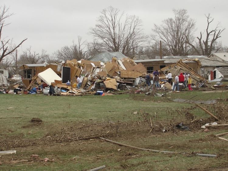
During the evening hours of April 9, the SPC issued a tornado watch for western and northern Iowa, eastern Nebraska and southeast South Dakota. Conditions within this region were favorable for the development of multiple tornadic storms and there was a 70 percent chance of multiple touchdowns. Around 2250 UTC (5:50 pm CDT), a strong thunderstorm developed over Burt/Cuming Counties in northeastern Nebraska. This cell slowly tracked east-northeastward and developed into a supercell as it moved into Monona County, Iowa. By 0021 UTC (7:21 pm CDT), a small tornado touched down roughly 2 miles (3.2 km) southwest of Mapleton. Within minutes, this storm quickly grew and intensified as it moved closer to the city. The tornado passed directly over the city at low-end EF3 strength. Turning northward, the tornado dissipated about 1 mile (1.6 km) north of Mapleton. A separate EF2 tornado struck the town of Early, where considerable damage occurred to homes and businesses.
Tracking northeastward, the supercell moved into Ida County, another tornado touched down around 0115 UTC (8:15 pm CDT) to the west of Arthur. This storm remained on the ground for 5 to 10 minutes, during which it damaged a few structures, before dissipating 2 miles (3.2 km) northwest of Arthur. Around 0120 UTC (8:20 pm CDT), the cell entered Sac County and the first in a series of multiple tornadoes touched down northwest of Odebolt. Over the following three hours, 13 tornadoes touched down across several counties. Around 0208 UTC (9:08 pm CST), a 1.5 mi (2.4 km) wide, EF3 tornado touched down southwest of Pocahontas. Remaining on the ground for over an hour, this tornado meandered along a 30 mi (48 km) path, producing several satellite tornadoes.
Officials blocked off the town and Governor Terry Branstad issued a disaster proclamation for the town. Early estimates indicated that 60% of the town was damaged and 20% was nearly flattened. Despite the damage, only three people sustained minor injuries.
On April 10, another moderate risk was issued. A PDS Tornado Watch was issued for parts of Minnesota, Michigan, and Iowa, as well as most of Wisconsin. With 16 confirmed tornadoes in Wisconsin, the outbreak ranks as the largest single-day event in April in the state. Severe damage occurred in the towns of Merrill, Kaukauna, and Cottonville. On the evening of April 10, a number of tornado watches and warning were issued stretching from southern Oklahoma to Sault. Ste. Marie, Michigan as well as central Ontario which became Canada's first tornado watch of the season. Thunderstorm watches and warnings were also reported as far away as northern and northwestern Ontario.
Non-tornadic events
Accompanying the tornadoes, large hail and high winds also impacted parts of the Midwest. Initially, these events associated with the outbreak were confined to Iowa and parts of Nebraska and Minnesota on April 9. In Iowa, hail was measured up to 3.5 in (8.9 cm) in diameter, resulting in some damage to homes and cars. On April 10, a large line of severe storms produced damage from northern Minnesota southward to the Texas-Mexico border. Most damage along this line resulted from straight-line winds; however, Wisconsin, 2 to 2.5 in (5.1 to 6.4 cm) diameter hail in La Crosse broke windows, dented cars and damaged homes. Roughly 3,200 insurance claims worth $12 million were later made in the city. Elsewhere in the state, winds up to 65 mph (105 km/h) downed numerous trees and power lines and in some instances tore roofs of buildings.
In Texas, winds as high as 95 mph (153 km/h) caused extensive damage to homes and businesses, resulting in roughly $100 million in damage. Numerous trees were felled across the region and a few structures were destroyed. In Dallas County, a few carports collapsed. Near Venus, 82 mph (132 km/h) winds damaged five homes.
On April 11, a strong derecho brought widespread damage to much of northern Alabama as well as parts of Mississippi, Georgia and Tennessee. Near Brent, Alabama, a wind gust of 110 mph (180 km/h) was recorded 70 ft (21 m) up on a radio tower.
Aftermath
Within days of the tornadoes in Iowa, excavators were brought in to clear debris and tear down homes that were damaged beyond repair. On May 5, nearly a month after the outbreak, President Barack Obama signed a federal disaster declaration for Buena Vista, Cherokee, Ida, Monona, Pocahontas and Sac Counties in Iowa. This allowed for government aid to be sent to the region and aid in recovery efforts. This declaration is set to remain in effect until May 1, 2012. A disaster outreach center was opened on May 6 at the Mapleton City Hall and the American Legion Post in Varina and would remain open through May 26. At these places, residents would be allowed to apply for small business and homeowner loans up to $2 million and $200,000 respectively.