
Area 13.46 km² Local time Sunday 9:55 PM | Time zone CET (UTC+1) Population 498 (1999) | |
 | ||
Weather 7°C, Wind N at 3 km/h, 59% Humidity | ||
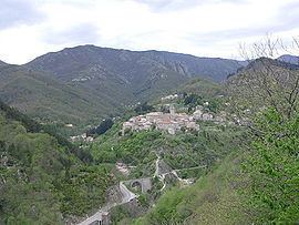
Antraigues-sur-Volane (Occitan: Entraigas) is a French commune in the Ardèche department in the Auvergne-Rhône-Alpes region of southern France.
Contents
- Map of 07530 Antraigues sur Volane France
- Location
- Hydrology
- History
- Administration
- Demography
- Distribution of Age Groups
- Civil heritage
- Religious heritage
- Environmental heritage
- Notable People linked to the commune
- References
Map of 07530 Antraigues-sur-Volane, France
The inhabitants of the commune are known as Antraiguains or Antraiguaines or alyternatively as Antraiguais or Antraiguaises
Location
Antraigues-sur-Volane is located 5 kilometres north of Vals-les-Bains and 14 km north of Aubenas. The village lies on the edge of the Ardèche Cévennes with the northern boundary ending at the Mézilhac Pass and the Vivarais Mountains.
Access to the commune is on the D578 road from Val-les-Bains in the south to the village then continuing north through the heart of the commune to Laviolle in the north. There is also the D254 going west from the D578 just outside the village via a mountainous route to Labastide-sur-Besorgues in the west. Similarly the D318 road goes east from the village by a mountainous route to Genestelle in the east. The commune is mountainous with some mountain roads accessing parts of the commune.
Hydrology
The Volane river flows from the north through the commune where it is joined by many tributaries including the Ruisseau de Rouyon, the Ruisseau du Bouchet, the Ruisseau des Fuels, the Rivière de Bise, the Ruisseau de Coupe (which forms the southern border of the commune), and many other unnamed streams.
History
Administration
List of Successive Mayors of Antraigues-sur-Volane
(Not all data is known)
Demography
In 2010 the commune had 544 inhabitants. The evolution of the number of inhabitants is known through the population censuses conducted in the town since 1793. From the 21st century, a census of municipalities with fewer than 10,000 inhabitants is held every five years, unlike larger towns that have a sample survey every year.
Sources : Ldh/EHESS/Cassini until 1962, INSEE database from 1968 (population without double counting and municipal population from 2006)
Distribution of Age Groups
The population of the town is relatively old. The rate of persons above the age of 60 years (34.2%) is significantly higher than the national rate (21.8%) and the departmental level (26.8%). Unlike the national and departmental allocations, the male population percentage for the commune is greater than the female population (49.8% against 48.7% nationally and 49.1% at the departmental level). The distribution of the population of the municipality by age groups in 2008 was as follows:
Percentage Distribution of Age Groups in Antraigues-sur-Volane and Ardèche Department in 2008
Sources:
Civil heritage
Religious heritage
Environmental heritage
The commune has been an integral part of the Regional Natural Park of Monts d'Ardèche since its inception on 9 April 2001. The commune has two ZNIEFF type II areas in its territory named: "Line of the crest of the Mézilhac to the Escrinet Pass" "Watersheds of the Volane, the Dorne, and the Bézorgues"
The town also includes four ZNIEFF type I areas: