Puneet Varma (Editor)

Antigua, Fuerteventura

Updated on
Edit
Like
Comment
Share on FacebookTweet on TwitterShare on LinkedInShare on Reddit
Country
  
Spain

Island
  
Fuerteventura

Website
  
www.ayto-antigua.es

Area
  
250.6 km²

Population
  
11,629 (2013)

Area code
  
928

Autonomous Community
  
Canary Islands

Time zone
  
CET (UTC+0)

Elevation
  
254 m

Postal code
  
35630

Province
  
Province of Las Palmas

Antigua, Fuerteventura httpsuploadwikimediaorgwikipediacommonsthu

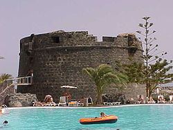
Antigua is a town and a municipality in the central part of the island of Fuerteventura in the Province of Las Palmas in the Canary Islands. It has a population of 11,629 (2013), and an area of 250.56 km². It is situated 17 km southwest of the capital of the island Puerto del Rosario.

Contents

Map of Antigua, Las Palmas, Spain

Sites of interest

  • Caleta de Fuste Castle, a heritage site
  • Centro Turístico Cultural Molino de Antigua (Molino de Antigua Cultural Touristic Centre): where works of major artists are exposed.
  • Salinas de El Carmen, the origin of these salt mines dates back to 1800
  • Paisaje Protegido del Malpaís Grande (Malpaís Grande Protected Landscape)
  • Atalayita aboriginal town
  • Cuchillos de Vigán, a natural Monument
  • Caldera de Gairía, a national monument
  • References

    Antigua, Fuerteventura Wikipedia