Anosy is a region in southeastern Madagascar. It borders Androy region in the west, Atsimo-Andrefana in the northwest, Ihorombe in the north and Atsimo-Atsinanana in the northeast. This region is 25,731 km2 (9,935 sq mi), about the size of the US State of Vermont, the island of Cyprus or the nation of Israel, running from approximately Manantenina in the northeast corner of the region, and west to Ranomafana and the Mandrare river. The distance from Manantenina at the northern edge of Anosy to the Mandrare river at the south is almost 150 km. "Anosy" means "island" or "islands" in Malagasy. Possibly, Anosy was named after the island in the Fanjahira (now named Efaho) river where the Zafiraminia first settled when they arrived in this region in the 16th century. Another theory is that the name means "land of the islands" because of the large amount of water in this region. During the rainy season, the Efaho valley floods, creating many temporary islands.
Tôlanaro, located 1,122 km south of Antananarivo, is the capital and the overall population of Anosy, primarily the Antanosy, was estimated to be 671,805 in 2013. At present it is doubling roughly every 15 years. In terms of people per square kilometer, this varies from 52 in the Tôlanaro District, 21 in the Amboasary Atsimo District, and only 14 in the Betroka District. There are also Antandroy living in the region, especially in the Tôlanaro District and in the Amboasary-Sud District, and Malagasy from other parts of the island who live and work in Anosy. The Betroka District also has Bara people, though they primarily live in the rural part of the district.
While the region has been a source of a wide variety of valuable exports for more than 100 years, some of them quite valuable, most of the people who live in this region are very poor, with an estimated GDP in 2004 of just $180, when the national average was @210. Four out of five (80%) of its inhabitants don't have access to clean water, one in six suffer from serious respiratory illnesses and literacy is less than 20% and 65% of the watershed slopes are highly degraded.
Anosy region is divided into three districts, which are sub-divided into 64 communes.
Amboasary Sud District
Betroka District (added in 2004)
Tôlanaro District
Subsistence farming is the primary source of income of most people living in Anosy, with rice being the crop and food of choice. Cassava is a very important food crop for those who can't afford rice year round as their staple food, which is most of the Malagasy living in this region. Yields for most crops are low, primarily due to the traditional methods of farming.
The three major cash crops in the Anosy region are coffee (primarily from Ranomafana area), Periwinkle (southwestern coast of Anosy and coast of Androy) and sisal (Amboasary area).
Coffee is primarily grown in the Ranomafana area.
Rosy ("Malagasy") Periwinkle: In 1958, Eli Lilly (industrialist) began research of Malagasy Rosy Periwinkle, hoping to find it would help in the administration of insulin. This effort was unsuccessful, but additional research led to the discovery of the chemotherapy agents vinblastine and vincristine, the latter of which is credited with increasing the survival rate for childhood leukemia from 20 to 80 percent.
Sisal: In 1928, the Societe Fonciere du Sud de Madagascar began testing the viability of growing Sisal near Ranopiso. While about 1,000 hectares were planted, by 1935 exports were only 65 tons. In 1932, this company obtained a 4,000 hectare concession in the Mandrare river valley where sisal was found to flourish. By 1947, five sisal companies had a total of 3,075 hectares planted and employed 1,470 people. In 1951, a station of the applied research institute IRCT - Centre de Recherches Sisalières du Mandrare - is set up in order to enhance sisal intensive farming and productivity. Production grew from 2,500 tons in 1950 to almost 29,000 tons produced in 1964. By 1959, due to the steel bridge erection easing the Mandrare right bank development, six companies had expanded the area, cultivated to 14,528 hectares and employed 4,502 people. Between 1953 and 1958, in part due to additional fees paid by France, these exports were worth 500 millions CFA. In 1962, there were 7,500 people (men and women) producing sisal and the value of sisal exports was just over 1 billion FMG (a year when 99 ships docked in Fort Dauphin) and while it was just over two billion FMG in 1964, by 1966 the value of exports was just under one billion FMG and the number of employees had dropped to 4,500 by 1967. By 1969, there were about 20,000 hectares planted producing about 25,000 tons per year (half of which went to France) which was the limit established for Madagascar by the FAO. However, in three years in the mid-1960s, the value of sisal decreased by more than 50 percent due to synthetic fibers which took sisal's place. In spite of this, production was almost 25,000 tons as late as 1970. Current production is appx. 3,000 tons per year from the Mandrare Valley.
In the parts of Anosy which receive enough rainfall, rice is the primary food crop, though in most cases only one crop per year is grown.
Secondary food crops:
Cassava
Rice
Vegetables
Biodiversity, conservation and ecology
Biodiversity
Conservation: Initiated in 1932 - creation of Andohahela natural reserve- Conservation has become an important topic in the Anosy area in the last 20 years.
Ecology
Andohahela National Park
Part of Kalambatritra Reserve
As of 1997–98, literacy at the Primary level in Anosy was 22% for boys, 23% for girls. Literacy is less than 20% in some of Anosy's rural areas.
As of 1997–98, in terms of Public Schools, in the Tolagnaro area there are 109 Primary schools, with an average of 42 students per teacher. There are 5 CEGs and 1 Lycee. The Amboasary region has an additional 73 Primary schools, 4 CEGs, but no Lycees. In terms of private schools, the Tolagnaro region has 33 Primary schools, with an average of 50 students per teacher. There are 3 Secondary (1st cycle) and 3 Secondary (2nd cycle) schools. Amboasary has 30 Primary schools, but just 1 Secondary school (1st cycle). Unfortunately, some of the Primary Schools in rural Anosy are in such poor state of repair they've been closed, with the nearest operating school up to 20 km away. One of the organizations working to increase the number of schools in this area, with the support of external funding, is Azafady. For an explanation of a school they've built in the Mahatalaky area with the support of the Peretti Foundation, see. For additional information and a very interesting collection of pictures about primary schools in the Anosy region, see.
Income from fishing estimated at between 3,000 and 5,000 Malagasy Ariary (MGA) in 2010, which was then US$1.50-2.50.
Geography, Geology and Hydrology
The information in this section is primarily from Vincelette et al. (2008) and is primarily about the immediate Tolagnaro region. For additional information see
The eastern and southern boundary of Anosy is the Indian Ocean. Along the ocean are coastal lagoons and then up to 50 or more km of sandy, rolling coastal hills that butt up against the Vohimena mountains. Rainfall is highest on the eastern side of the mountains and decreases as one moves west.
The Vohimena mountains dominate the Tolagnaro region. They terminate just outside Tolagnaro at Bezavona (Pic St. Louis) which is 529 m. Bedrock inland is granite. At Point Evatraha and near Mandena it is cordierite gneiss. There is an external barrier dune complex along the coast which runs north, up the entire east coast. Between northern Mandena north to Manafiafy (Saint Luce), there are heavy mineral deposits of ilmenite, zircon, rutile and monazite, with these mineralized sands averaging 18 m. thick in the Mandena region. There are also similar deposits at the south end of Petriky (west of Vinanibe).
The 3 primary hydrologic drainage areas in Anosy are the Mountain Zone (30+% of the total catchment area), with steep slopes causing rapid, high runoff and clearly defined rivers; the Bedrock Plain which has rolling hills with low relief and several large rivers and the Coastal Sands, which can be found in bays ranging in size from more than 20 to only a few km2. These bays are clearly defined and are cut by meandering rivers. Along what are generally coastal dunes at ocean's edge are ribbon lakes from which water discharges into the ocean either through seepage or channels which cut through the dunes. These can be further subdivided into the Andriambe, Ebakika, Efaho, Fanjahira, Lakandava, Lanirano, Manampanihy, Mandromodromotra, Vatomena, Vatomirindry and Vatorendrika basins.
There are 3 major rivers in southern Anosy : the Mandrare along the southern border, the Efaho (formerly called the Fanjahira) just west of Tolagnaro and the Manampanihy which drains the Ranomafana valley, emptying into the ocean at Manantenina. Other rivers in the Anosy region include the Isoanala, Manambolo, Mangoky, Menarandra and Isoanala.
Health is a challenge in Anosy, especially for children, as up to 4 in 10 in rural areas die before the age of 5. This is in part because 80% of the population doesn't have access to clean water.
Family Planning: With a population annual growth rate of 2.9%, the number of people living in Anosy is projected to double every 13 to 15 years.
Hunger:
Malaria:
Nutrition & Hygiene:
Health Projects:
Sanitation: In 2010, WHO/UNICEF estimated only about 1 in 10 Malagasy had access to improved sanitation facilities. The diarrhea caused by this results in large numbers of deaths of children. Azafady, an NGO working in the Anosy region, has sought to increase the number of latrines through several different projects over the past 10+ years.
Because of the Europeans which began visiting the Anosy region over 500 years ago, there is a long history of maps of this area.
NGA Chart 61522: Faradofay (Fort Dauphin) and Approaches There are several different maps of the Anosy area, several of them available online courtesy of the University of Texas' (Austin) map collection. In terms of maps of Anosy for sale in Madagascar, see FTM's website including maps No. 12 Tolanaro (eastern coast north of Tolagnaro) and No. 11 Ampanihy (which is actually a map of southern Madagascar, from Tolagnaro across to Toliary). These are a part of their collection of 12 Maps of Madagascar. They also have a map of Southern Madagascar across to Toliary. In addition there is a recent map of Tolagnaro as well as one of the Andohahela National Park.
In terms of much older, European maps of the area which are online, for Fort Dauphin, see Flacourt (mid-1650s). For a map of the Anosy region done at the same time, see Flacourt (1656). For Flacourt's map of the community at Tranovato see
For a map of the coastline of eastern Madagascar (Mananjary south to Fort Dauphin), with detail about both the Fort Dauphin harbor as well as St. Luce (Manafiafy), see. For a map of concessions in the Fort Dauphin area see For several other maps of the Fort Dauphin bay, see
For an in-depth description of sailing directions (landmarks visible from the ocean for various places to harbor in Anosy), see Great Britain Hydrographic Department. (1891).
Mining has been occurring in Anosy for at least the last 100 years as Mica has been an export since the early 1900s, Uranothorianite was mined from the 1950s to the mid-1960s, for several years being Madagascar's second most valuable export. Sapphires briefly became a major export in the early- to mid-1990s and today QIT Madagascar Minerals (QMM), which is 80 percent Rio Tinto and 20 percent Malagasy government) is exporting 750,000 tons per year of Ilmenite, along with 40,000 tons per year of Rutile and Zircon. There are also major deposits of bauxite and prospecting is ongoing for uranium as well as a variety of rare earth minerals.
While quite a bit of mining has been done in Anosy over the last 60 years, a paraphrased translation of a 2002 post in Malagasy on the internet shared skepticism of the benefits to Malagasy of the mining which has occurred in Anosy to date:
Is Manantenina, the town near the major Bauxite deposit in Anosy, progressing today?
How many large stone houses are left in Ambatomika where Uranium was mined?
How many schools were built in Sarisambo with funds from the Monazite mined there?
What is left in Andranodambo where Sapphires were mined? Holes are the only souvenirs left here.
What are the benefits left in the Tranomaro area where Mica was [and continues to be] mined?"
Bauxite is an aluminium ore which is the main source of Aluminium. There are an estimated 100 million tons of bauxite near Manantenina where it has been found over a 40km2 area. While this deposit has been studied for the last 45 years and in 2008 Rio Tinto indicated both a mine and refinery were "development projects," it is not yet being mined, due in large part due to the lack of infrastructure in this part of Madagascar (100 km north of Tolagnaro).
Ilmenite is mined for Titanium Dioxide production, which, when finely ground, is a bright white powder which is widely used as a base pigment in paint, paper and plastics.
Since 2009, 750,000 tons per year of Ilmenite is being exported by QMM to Canada, with a potential for this to grow to 2 million tons per year. (In addition, 25,000 tons per year of Zircon and 15,000 tons per year of Rutile is also being produced as part of their Ilmenite mining—see below). The estimated life of this mine is 40 years. Almost $1 billion was spent developing this mine, including a new harbor at Port Ehoala. per Book chapters, News reports, Research studies, etc.)
per the Malagasy government
per various NGOs
per Rio Tinto/QMM & SODEXHO
per the GIZ & World Bank
Mica's value is based on its unique physical properties. It has a crystalline structure which forms layers which can be split (delaminated) into very thin sheets (0.125 to 0.025 mm. or thinner), while remaining stable when exposed to electricity). This gives it superior electrical properties as an insulator and a dielectric, as it can support an electrostatic field while dissipating minimal energy in the form of heat. It also has a high dielectric breakdown and is resistant to corona discharge. It is also stable when exposed to light, moisture and extreme temperatures. Mica is also chemically inert, dielectric, elastic, flexible, hydrophilic, insulating, lightweight, platy, reflective, refractive, resilient, and ranges in opacity from transparent to opaque.
The two commercially important micas, used in a variety of applications, are Muscovite, the principal mica used by the electrical industry, thermally stable to 500 °C, is used in high frequency and radio frequency capacitors. The second is Phlogopite, which remains stable up to 900 °C and is used in applications in which a combination of high-heat stability and electrical properties is required.
Discovered near Tranomaro in 1912 (though it can be found in crystalline schists from Fort Dauphin up to Ihosy), within 6 years 18 tons/yr of phlogopite mica was exported, with over 500 tons/yr by 1928. By 1947 there were 50 different companies mining mica, though the majority of the mining was done by just 10 of them. There were still 15 mines operating in 1962, with active exploration going on at 20 other sites. Mining companies included the Etablissements W. Boetschi, Les Fils de O. Jenny, the Societe des Minerals de la Grande Isle at Benato and th Union des Micas. However, in 1963 the US stopped purchasing mica, resulting in the closure of several mines and the production being cut by 2/3rds. The biggest mine was and still is at Ampandandrava, about 250 km from Tolagnaro, which currently is being mined by Groupe Akesson, exporting 1,000 tons/yr.
Monazite, a reddish-brown phosphate mineral, contains rare earth metals. It was originally mined from beach sands at and near Tolagnaro by Societe d'Exploitation des Monazites, which had a treatment plant which produced 200 tons/yr, though in 1964 the plant was moved to Vohibarika. There are still an estimated 310,000 tons of this in the heavy-mineral sands near Tolagnaro.
Heavy-mineral sands near Tolagnaro have an estimated 177,000 tons of monzanite, with another 64,000 tons with a high Thorium content located 100 km north of Tolagnaro.
Rutile, a mineral composed primarily of Titanium Dioxide (TiO2), is an important constituent of heavy mineral sands ore deposits which typically also include Ilmenite and Zircon. The two main uses of Rutile are either in the manufacture of refractory ceramic (as a white pigment), and for the production of Titanium metal. About 15,000 tons/yr are being exported by QMM as a byproduct of its Ilmenite mining in the region. [see Ilmenite above]
Sapphires are worn as jewelry. They are also used in several other applications, including infrared optical components (i.e. scientific instruments), high-durability applications (windows, wristwatch crystals and movement bearings) and very thin electronic wafers (i.e. used in insulating integrated circuits).
The presence of Sapphires in Anosy was first written about by Etienne de Flacourt in 1658, they were most likely also seen by Barthelemy Hugon in 1808; and sapphire crystals were described by a French geologist working in the mica mines near Tranomaro in the 1950s. However, it wasn't until 1991 that very high quality blue sapphires of up to 35 carats (similar in quality to those from Kashmir) were purchased by gemologist John Darbellay near the Antandroy villages of Andranondambo and Marohoto (20 km from Tranomaro) in the Manambolo valley, just 80 km northwest of Tolagnaro (though it takes a 6-hour drive of almost 210 km to get there).
Thai purchasers arrived in 1993, soon joined by traders from Israel, Sri Lanka and several other countries, and by 1994 almost 10,000 miners had rushed to the area from all parts of Madagascar. However, while the initial finds of sapphires in this area were only 2 to 3 meters below ground, in gravel held by clay, since then most sapphires found are almost randomly embedded in a limestone or marble bedrock. These rocks take extensive work to obtain, requiring sledgehammers, spikes and small fires.
Thus, the number of miners was only about 5,000 a year later; today Andranondambo only has about 1,000 residents, many occasionally continue to search for sapphires, though they also farm, are vendors, etc. Foreigners visit only occasionally, as most middlemen are now Malagasy. Three different companies attempted to mine commercially, but only for a brief time. An Environmental Impact Study conducted in 2004 found the area "highly degraded" and the remaining dry spiny and gallery forest, threatened ecosystems, "fragmented."
Thorite is an important ore of Uranium. A variety of Thorite often called "Uranothorite", rich in Uranium, is highly radioactive.
By the end of World War II, Madagascar was viewed by France as having a "treasure-trove" of minerals, so several of France's nuclear experts told Charles de Gaulle he needed to keep Madagascar as a colony "regardless of political costs." Multiple deposits of Thorium and Uranium, principally in the form of Uranothorite, were discovered near Tranomaro, in the loop of the Mandrare river, in 1953 by a French Geological Survey, just 80 km northwest of Fort Dauphin. However, getting there by road meant driving west almost to Amboasary and then northeast for a total distance from Tolanaro of about 200 kilometres. The local farmers, who raised cattle and goats, and grew rice, manioc and maize, knew of these deposits, calling these rocks "vatovy" to describe their density and black color. They used them as slingshot ammunition and fishing weights.
In 1953, the French Commissariat de l’Energie Atomique (CEA) [see what is now called the Commissariat à l'énergie atomique et aux énergies alternatives] established their center for mining at Ambatomika ("place of Mica rocks") and brought in mining equipment, built a mill, lab, offices, a small clinic, a store as well as housing and a clubhouse for the expatriates living there. What they milled was mined from small, open-pit mines, which had a minimum overburden (for a picture of one of these mines see) within a 20 km radius of this site. Some of these sites were mined by colonial concessionaires who sold their ore to the CEA.
By 1958, there were 44 Europeans working with 440 Malagasy there, a limited number of mid-level Imerina with many more Antandroy and some Betsileo working as guards, porters and miners. Early, artisanal mining was not recorded, but from 1954 to 1963 almost 4,000 tonnes of highly radioactive Uranothorite was mined and exported to France. By 1962, these exports were worth CFAF 389 million, and by 1964 this was Madagascar's second most valuable export. In 1963, the original Ambindandrakemba mine was exhausted, the site at Ambatomika was lost, and all the equipment was moved north 40 km to Betioky, near the Belafa ore body which was thought to have somewhere between 2,000 and 5,000 tons of uranothorianite, embedded within 100,000 to 300,000 tons of ore.
In addition to the CEA, there were 4 private mining companies in 1963 including C.F. Lanouo, Kotovelo (plant at Marovato), Societe des Minerals de la Grand Ile (mine at Ambatoaho, Societe d'Exploitation des Mines d'Andranondambo (mine at Bevalala) and the Societe Miniere et Forestiere at Betanimera. In 1963 these producers were being paid 2,850 to 5,000 CFAF/kg for uranium metal content and CFAF 100 to 350/kg of Thorium. However, due to the French having found much larger deposits in both Gabon and Niger, and due to the by then worn out equipment and exhausted mines, mining ended in 1968. While the higher-grade deposits have been exhausted, there is still a considerable amount of lower-grade material in this area.
In 2005, the Malagasy Government conducted aerial magnetic and radiometric surveys of the area, finding the amounts of Thorium and Uranium increased as one moves west, though this could be due to "transported cover" on the Easter side of the area. In 2007 drilling by the Canadian firm, Pan African Mining Corporation, at one site found "high-grade uranium mineralisation grading 4,329 ppm uranium", with deposits as far down as 60 metres below the surface. In 2009–10 LP HILL began ground traverses for Thorium and Uranium in the Marodambo area (in addition they have permits to search for Cordierite, Garnets and Sapphires).
London-based Bekitoly Resources Ltd. is also involved in the strategic acquisition, exploration and development of uranium, rare earth deposits and other minerals in Madagascar. Their property occurs within includes 8 of the historical open-pit deposits. Their exploration activities have included airborne radiometrics and hyperspectral surveys, ground radiometrics and magnetics, mapping, grab sampling, trenching and drilling which have identified numerous widespread radiometric anomalies with uranium and thorium scintillometer readings of up to 26,257 and 43,215 ppm respectively, as well as the rare earth elements of Cerium, Dysprosium, Erbium, Gadolinium, Lanthanum, Neodymium, Praseodymium, Samarium and Yttrium. Their data also suggests there are numerous additional areas "with good indications" that remain untested.
Tourmaline is a semi-precious gemstone which has been found near Ampasimainty, Ianakafy and Iankaroka, all south of Betroka. It has also been found near Behara and Tranomaro, which are both closer to Amboasary. A 7 cm Tourmaline crystal found near Tranomaro was recently sold by Arkenstone Fine Minerals for US$2,250.
Zircon is used in the decorative ceramics industry as a substance which can be added to another material in order to make the ensuing system opaque. It is also the principal precursor to metallic zirconium (fairly uncommon), but also to all compounds of zirconium, including Zirconium Oxide (ZrO2), which is a highly refractory material. About 25,000 tons/yr of Zircon are being exported by QMM as a byproduct of its Ilmenite mining in this region [see Ilmenite above].
The estimated population of the Anosy region was 671,805 in 2013.
While the people who have historically lived in Anosy are known as the Antanosy, they may be more accurately described as "those from Anosy" given Anosy's history. In addition there are many Antandroy living in Anosy, primarily Tolagnaro, along with Malagasy from the rest of the island, many of them now working for QMM's mining efforts. There are Asians who own many of the shops in town and there are also a few Europeans living in Tolagnaro working in the area(s) of Conservation, Mining, Tourism or for the Catholic Church. While there were many French living and working in the Anosy region during the French occupation of Madagascar, most had left by the mid-1970s. Tolagnaro was also the center for work by American Lutherans, primarily in southern Madagascar, from the 1890s to the mid-1980s (see History of Anosy below). Much more recently, for several years there were over 700 expatriates, primarily from South Africa, who worked on the construction of the new port and mining facilities.
The majority of those living in Anosy practice traditional Folk religion.
The two largest Christian denominations in the Anosy region are the Roman Catholic and the Malagasy Lutheran churches. There is also a small Muslim community.
The Catholic Church was established in what was then still Fort Dauphin in 1896. It currently has 5 parishes, with about 170 congregations and 16 Cures.
Of the Protestants in Anosy, the vast majority are Lutheran. There are approximately 20 Malagasy Lutheran pastors working with 134 churches in the Tolagnaro Synod, meaning each pastor works with between 3 and 12 churches. For further information see
In addition to the Malagasy Lutheran Church, the Church of Jesus Christ in Madagascar (FJKM) has several congregations in the Anosy region as do several other Protestant denominations.
Airline Tolagnaro is serviced by Air Madagascar, with daily flights to and from Antananarivo.
Bus Service Buses run both north and west from Tolagnaro, most are overcrowded, many are in poor repair and some are trucks with metal benches welded into the back.
Roads Only 50% of the roads in Anosy were passable in 2009, with the rest either closed during the rainy season or no longer passable at all. 4WD is recommended. While the road was paved from Tolagnaro west through Amboasary to Ambovombe, most of this pavement is wrecked. While the World Bank helped pave the roads in Tolagnaro and QMM has built a highway to export its ilmenite to the harbor and the Chinese have repaired the road from Tolagnaro to Ranomafana, that is the limit of recent road repairs.
In the last ? years the road north from Tolagnaro through Manantenina to Vangaindrano has been opened and is now used as one of the ways to drive north to Antananarivo.
Shipping The construction of the new Ehoala harbor has greatly improved Anosy's port facilities. Its previous (and historic) harbor was known for the very large number of ships which have gone aground in that bay over the years (10 in the last decade).
Given its pleasant climate (average temperature of 20° in July to 27° Celsius in January), magnificent beaches, natural reserves (including several containing lemurs), variety of hotels and that it's only a one-hour flight from Antananarivo, some have given Tolagnaro the title of "la cote d'Azur Malgache." Popular places to visit include Evatraha, Libanona beach, Lokaro, Manafiafy, Nahampoana and Vinanibe.
General tourism information about Tolagnaro can be found at a variety of sites:
Tourist Agencies in Antananarivo: There are a variety of tourist agencies in Antananarivo one can work with if you'd like to visit Tolagnaro.
Tourist Agencies in Tolagnaro: There are also several tourist agencies in Tolagnaro one can work with.
The average temperature in Tolagnaro ranges from 26 °C (79 °F) in January and February to 20 °C (68 °F) in July, with the temperature of the ocean ranging from 25 °C (77 °F) in January and February to 19 °C (66 °F) in June and July. The humidity of Tolagnaro ranges from 77 to 84 percent all year long.
In general, Anosy's rainfall ranges from very wet and humid on the northeast to increasingly arid as one moves towards the southwest. In Tolagnaro, the average rainfall is over 150 millimetres (5.9 in) per month for November through the rainiest month of April (which is almost 190 millimetres (7.5 in)) and then dips down to less than 100 millimetres (3.9 in) for the months of September and October, for a total of 1,800mm/year. Tolagnaro is a windy town, with Force 6 winds from 6 to13 days per month for five months of the year (including August through November) and Force 4 winds of 11 to 24 days per month for 11 months of the year.
For a view of current wind speeds and wave heights see the following Windfinder [2] link.
While Tolagnaro historically has had electricity for many years, the growth of the town and poor condition of the town's generators has meant QMM now has taken over the production of the town's electricity. The only other town in Anosy with electricity is Amboasary.
As of 2008, rural electrification in Anosy was only 7%. While a program entitled PEPSE Anosy was proposed to provide electricity from wind generators to 8 towns (Analapatsy, Ifarantsa, Ifotaka, Mahatalaky, Manantenina, Sampona, Soanierana & Tanandava), there is no evidence this project has been started [see Fondation Energies Pour le Monde (2008) and MARGE (2005) for further information].
The early history of Anosy at this point in time is based primarily on archeological digs in the Efaho valley, just west of Tolagnaro, though there has also been some work done just east and north of town. By far the best source regarding the history of Anosy (especially the Efaho valley) in the last 1,000 years is by Rakotoarisoa (1998). Other excellent sources for the early history of Anosy are by Wright et al. as well as Dewar and Wright who also describe the early history of several other parts of Madagascar. Also see
Possible that Zafi(n-d)Raminia, who would end up in Anosy several hundred years later, left the shores of the Red Sea.
Earliest sites in Anosy found by archeologists to date focused on fishing, others possibly on cattle. Gardening (mainly tubers) was done as well as hunting (including lemurs), but no rice cultivation. Iron working was also present.[7] Trade was limited to the northeast, along the coast, with no indication of imported pottery. Settlement sites were small (0.5ha in size), seasonal in some cases and even temporary, based on the need to move to obtain food. They were concentrated near the coast in dunal areas and were part of what was a very simple economic and social system. One of the sites is located on sand dunes overlooking the Efaho estuary (Rakotoarisoa, 1998).
Evidence that between 13th and 15th centuries those living in Anosy were working Chlorite Schist to use trading networks which included the importation of Chinese Celadon.
Earliest oral sources of information about Madagascar which survive in written volan'Onjatsy or sorabe (Arabic-Malagasy script) documents from the southeast are being used to reconstruct this period of time. This source also indicates that sometime after the 11th century, the Zafi(n-d) Raminia, having traveled from Sumatra to somewhere on the shores of the Red Sea to Mangalore (India), arrived in the lower Mananjara, from which they eventually moved to Anosy.
14th century:
China began trade with East Africa.
Zafindraminia, who would move down to Anosy in the next century (see below), first arrived in northeastern Madagascar where they lived in the area of Iharana (between Vohemar and Antalaha), which was a major Indian Ocean trading area at that time. However, not that long after this they moved south to the area of Mananjary, Fianarantsoa, only to eventually be forced to again move south to Anosy by the Antambahoaka people.
In the Ambinanibe Phase, settlements in Anosy hadn't changed much yet from the Mahivolo Phase, as they were still near the beach, were mostly less than 1 ha in size, with evidence of fishing, cattle raising and bowls imported from the Far East.
Cultivation of sweet potatoes (bageda), iron working further developed. Signs of connections with broader Indian Ocean exchange networks with little evidence of settlement hierarchy or social differences and little change in population. Settlements were larger and primarily on the flood plains, with those near the coast on lagoons rather than the ocean itself (Rakotoarisoa, 1998).
Early 1300s – Wreck of a Gujarat ship off coast of Anosy. While some argue stranded Indians went north to found the Zarabehava, the Antesaka royal family. From there they moved west, providing royal families to the coastal Antandroy (the Zafy Manara), the southern Bara (Zafy Manely) and eventually the Mahafaly and Sakalava, Kent (1992) argues against this (p. 857).
1315 – Chu Ssu-pen of China created a nautical map which depicted the location of Madagascar together with its coastline, winds and ocean currents.
15th century and arrival of the ZafiRaminia
1405–1433 – Seven exploration and trade voyages led by Zheng He from China to East Africa, with fleets as big as several hundred ships. While there's no evidence they ever came near Anosy, porcelain from China was traded there.
1478 – Gujarat ship from Cambay (now called Khambhat) in northern India shipwrecked near Sofala.
Tranovato and Portuguese phases (16th – early 17th centuries)
16th century:
Middle and upper Efaho valley settled where communities were still few though larger, many had moved further inland. The larger ones were "centers" which were from 2 to 7.5 ha in size and appear to have been fortified with both ditches and wooden palisades.
Evidence of imported porcelains from the Far East as well as stone and earthenwares and glass bottles from Europe.
The ZafiRaminia, a migrant group were defeated by the Antambahoaka people from Mananjary, Fianarantsoa which claimed Arab and Islamic (Silamo) origins (some claim direct descent from the uncle of the prophet Muhammad), began moving into the Efaho valley due to the war which the Zafikazimambo was successfully waging on the Antambahoaka (only women and children were being spared—but even then being placed in confined areas) in the Mananjary region (p. 854). By the time they moved to Anosy they had already lived in that region of Madagascar long enough to have become assimilated into the Malagasy population of that area, to the point that did not have mosques or any other Islamic institutions. They had, however, retained Arabic script (sorabe) and had vague memories of the Quran as well as several socio-religious practices. They also had both soothsayers (ombiasa) and scribes (katibo), who had the ability to both write and interpret the Sorabe (see Sorabe alphabet) which were venerated, an Islamic tradition. This was according to Racoube, grand ancestor of Anosy and prince of Mangalore, who had fled to Madagascar in fear of his older brother.
While some argue the Zafindraminia came to Anosy as late as 1625, Kent (1992) argues it was around to the turn of the 16th century. While they were initially not able to create a "centre of authority among the Antanosy" Kent writes they did introduce sombili (that only descendents of Raminia could slaughter domestic animals), wooden huts, owning cattle as a sign of wealth, the idea of kinship and a "will to power" (p. 855). Eventually they attained a position of power.
This began the start of a time of cultural transformation of those living in the Efaho valley as they established a dynasty that went on for the next 200 years. (Some claim this clan eventually provided a ruling caste for the Antandroy, Bara and Sakalava and a significant role in the Betsileo, Imerina and Vakinankaritra dynasties. This in part due to their control of ritual sacrifices, ody (powerful magical charms) which it was claimed could bring good luck, ward off evil, etc. This also due to their ability to write, at that time also viewed as a magical power. and)
Changes included the establishment of a much more hierarchical society. Previous to the arrival of the ZafiRaminia, the indigenous people, described as a social group which was "black," were divided hierarchically, with the Voajiry (original royalty of those who lived in Anosy before the arrival of the ZafiRaminia and who therefore could slaughter animals) over the Lohavohitra (highest rank of commoners who could only slaughter fowl) over the Ontsoa (lower commoners, though free, never wealthy, but instead farmers, fishermen and hunters) over the Andevo (slaves).
On the other hand, the ZafiRaminia, who moved into this area, coming from the northeast per Etienne de Flacourt, were described as "white." They established a deeply stratified society at the top of which were the Raondriana, who claimed distant Arabian origins. Next came the Raondriana descendents, then commoners and then slaves. Their men of royalty intermarried with women of the local nobility and so took over the property rights of their wife's family. They formed the Raondriana (generally translated as "princes" in early European writings, these were the royalty who were declared "Masters of the Earth" by the remaining Voajiry). They had the right to slaughter animals, key to honoring the ancestors. They were over the Zanakandriana children of the nobles), those who were of mixed Andriana and lower caste blood, who also had the right to slaughter animals. Both of these two castes were over the Onjatsy (commoner caste), whose task it was to serve the Andriana and who could only slaughter chickens, ducks and geese. Anosy was divided up into autonomous regions known as Mahavita tena, with a king, known as the Andriambahoaka. While were considered to be of a divine lineage, they couldn't amend what were known as the "Basic Laws." Rather they were under the control of their subjects, asked to arbitrate when there were states of emergency (Rakotoarisoa, 1998).
Time of military campaigns as the Zafiraminia (newly arrived) seized power and implemented strict socio-hierarchical system associated with royalty and the ancestors.
Over time the primary center of the Zafiraminy moved from Efangitse inland to Fanjahirambe, a village of 7.5 ha.
Population became stratified, with settlement and socioeconomic hierarchy and rise of "Paramount Chiefdoms" as well as subchiefs, and shifting coalitions. According to Kent (1992):
[the Zafindraminia's] acquisitive impulse, internal rivalries, and inability to find symbols that would transcend the needs of individual Rohandrian (as the highest Zafindraminia estate was called) and unite all of the Antanosy, all went against the formation of a single state ruled by the Zafindraminia kings. Instead, two parallel societies developed with the Zafindraminia copying tompontany hierarchy. While the French established Fort Dauphin in Antanosy during 1643, the two societies were in a state of interpenetration not only as a result of exogamy but also because the upper estates on both sides were shifting toward political centralization. During its three decades on local soil, from 1643 to 1674, Fort Dauphin deflected this process completely and political unity would continue to be elusive... [as] the Zafindraminia were not kingdom-builders. (pp. 855-856)
Rice and cattle were the primary sources of food. Long-distance trade with ceramics imported from China, England, France and Portugal, while cattle were exported (Rakotoarisoa, 1998).
1500 – Diogo Dias, captain of a Portuguese ship which was part of the 2nd Portuguese India Armada, formed by 13 ships, and commanded by Pedro Álvares Cabral, sailing from Lisbon to the East Indies, became separated from the fleet on May 23 west of the Cape of Good Hope (South Africa) during a fierce storm which sunk 4 of the ships, including that of Admiral Bartolomeu Dias, Diogo's brother. Diogo Dias' ship was blown west and south. In sailing back north to rejoin his fleet, on August 10 he and his crew become the first Europeans to see Madagascar, somewhere near what was to become Fort Dauphin in Anosy. At first they thought this was Mozambique, but as they sailed north along the coast, they realized it was an unknown island which they named Ilha de São Lourenço ("Saint-Laurent" in French) in honor of the Feast of São Lourenço held on that day. Reporting this when he returned to Portugal, it was determined this was the island of Madagascar, originally identified by Marco Polo. Even so, Madagascar was labeled as São Lourenço (Saint-Laurent in French) on European maps for the next several hundred years. For more information about Portuguese exploration efforts at this time, see Portuguese discoveries.
1506 – Fernando Soares, a Portuguese explorer sailing back to Portugal from India, sailed past what was to become Fort Dauphin (now Tolagnaro) harbor on February 18, and while his ship was hit by lightning, he didn't anchor there.
1507 – Five shipwrecks along Madagascar's southern coast since 1504.
Much of the information about this period is from Larson (2007) which is a much more in depth analysis of this time. Also see Pearson (1997), Canitrot (1921). and Oliver (1902).
1505? - Speculated that the Tranovato described below was built by Portuguese survivors of one or more shipwrecks. Pearson (1997), along with many other sources, including early Portuguese historians of this era, indicate the Tranovato was built by shipwrecked Portuguese, anxious for their safety. Clarinot (1927) indicates that Father Mariano wrote that Francisco Albuquerque built the fort when he was shipwrecked there on his attempted return from India in 1505 [see 5th Portuguese India Armada (Albuquerque, 1503)]. However, Clarinot felt that based on a variety of data, the Tranovato must have been built later than the above, some time between 1520 and 1530, possibly 1527? In this case, this is (one of) the first European building erected on Madagascar. However, Larson (2007) argues the building is older than that, most likely built as stone structures that were not originally a fort, but rather constructed by Zafiraminia Raondriana when they first arrived in Anosy.
1508 – On August 4, Diogo Lopes de Sequeira and Duarte de Lemos of Portugal, sent to analyze the trade potential of Madagascar (looking for both gold and silver), dropped anchor in Ranofotsy bay where they found 2 crew from the ship Santa Maria da Luz, companions of João Gomes de Abreu. They also met the only 2 survivors of a Gujarati shipwreck which had happened 30 years earlier. He proceeded on to a bay he was told was named Touroubaya, named after a captain of another shipwrecked Gujarati ship who'd settled there (Pearson, 2007). Those living there said they were the descendants of shipwrecked sailors. Antonio, another Portuguese mousses and companion of de Gomes de Abreu who was living there, knew Malagasy, so he became the translator for Captain Sequeira when he met with King Andriamony (also named "Diamom" by some), one of the Raondriana in this area. Thus began 500 years and counting of very complex Malagasy-Vazaha ("foreigner") interactions in this area.
Diogo Lopes took on lots of food and left with another ship captained by Jerónimo Teixeira which had just arrived there as well. However, on August 12 they were separated by a storm, with Captain Lopes ending up at a small peninsula which provided an anchorage well protected by the wind blowing that day. Here they found cattle, wild boar, yams and rice provided by the local Malagasy, who were very friendly. This site, known as Taolanara, is where the name of Tolagnaro comes from.
As seen above, by this time Anosy had become a place for European sailors shipwrecked along Madagascar's southern coast to go to until the next European ship dropped anchor in one of its bays and could rescue them.
1510 – A Portuguese named João Serrão attempted to set up a trading post in Anosy, location unknown (possibly at the site known as "Tranovato" which is located where the Efaho and Satra rivers meet—protected by water, it may have been viewed by the Portuguese as a safe place to establish this?). [According to oral traditions from the village of Andramaka, the Zafiraminia viewed this location as a place for privileged royalty. These were the Zafy Voliandro, whose descendents became the Andriamanjaka and Andriambola princes of this area. There is a royal cemetery located across the river from this location which Flacourt called the "Cimetiere des Grands de Fanshere."]
1527 - First of two voyages by the French Parmentier brothers who landed on the western coast of Madagascar.
Four shipwrecks along Madagascar's southern coast. Pearson (1997) wrote after the surviving 70 of 600 Portuguese sailors shipwrecked along the southern coast of Androy (southwest of Tolagnaro), arrived in Anosy, they worked with other shipwrecked Portuguese already there to construct a stone fort, held together by lime, on a seasonal island (which the Portuguese name Ilha de Santa Cruz) on/in the Fanjahira river, which was known as Tranovato ("House of stone"). It was located about 9 km west of what a century later would become Fort Dauphin.
1529- French sailor, navigator, cartographer and poet Jean Parmentier described the ocean off eastern Madagascar as "La Mere Sans Raison" ("The Ocean Without Reason").
1530 – Several Portuguese ships commanded by two brothers, Duarte and Diogo da Fonseca sent to Madagascar by Portugal's king to search for shipwrecked sailors, but only found one Frenchman and 4 Portuguese (from 3 different shipwrecks). There were rumors of other shipwrecked sailors who had moved inland to Antanosy villages, but these were never proven to be true as a search of the interior was never conducted. However, in 1613 Portuguese visiting (see below) were told by an Antanosy about Portuguese his ancestors had welcomed, teaching them local skills. They had intermarried with local women and had many children. However, they eventually built a ship on which they sent sail to Africa, never to return, even though they had told their wives and children they would come back to get them, bringing goods for the locals. According to some Dutch sailors, they had all perished.
1531 – Some of the Antanosy who shared about the departure of the Portuguese from Anosy indicated to later European explorers they had not met a violent end, some even leaving on their own (see "1613" bullet below). However, others indicated some of the Raondriana had in fact killed these foreigners (Pearson, 1997). The story was a massacre had occurred, led by Zafiraminia princes who attacked the Portuguese during a celebration they were having outside the protection of their fort, killing 70, leaving just the 5 who were on guard duty in the Tranovato alive (along with a Frenchman who'd been shipwrecked and was awaiting rescue). On the other hand, Larson (2007) argues this story appears to have been first told by Jesuit missionaries almost 100 years later, frustrated with the king of Fanjahira (who they blamed for this event), as he was unwilling to give a second son to them to take to Goa, India for a Catholic education. The 6 survivors at Tranovato were picked up by a passing ship (Pearson, 1997). In either case, Portugal's minimal attempt at setting up a colony ended after the Portuguese either left on their own or were mostly killed, the few survivors rescued.
1534–38 – 5 shipwrecks along Madagascar's southern coast.
1540 - According to Camboué (1910) a group of Portuguese "emigrants" included one or more "religious who...accompanied the colony of emigrants."
1547 – Jean Fonteneau, a French navigator, explorer and corsair, described Anosy as follows:
The people there are negroes and valiant: but they are wicked and do not wish to trade merchandise with any strangers. The Portuguese king had there formerly a factory [at Ranofotsy], where ginger was extracted; but the natives killed them and no longer wished to trade with the Portuguese...The island's coast is very dangerous, especially the south coast and part of the southeast. Shoals run for more than 30 leagues" (as cited in Pearson, 1997).
1550 – Portuguese shipwreck off the coast of Vinanibe (just south of the Tranovato), by which time few if any Portuguese were still living in Anosy. By this time the Malagasy living in this area had been labelled as "meschans" () by the French.
While some Zafindraminia indicated they had intermarried with Portuguese, the Europeans left very little other impact behind.
1587 - According to Ray (1979), Portuguese Frei João de São Tomás became the first monk of the Dominican Order to visit Madagascar.
Ehoala phase and initial French settlement at Fort Dauphin (17th century)
Ehoala phase of Anosy with focus on irrigated rice, but manioc had also been introduced. Settlements were smaller and located primarily in upper valleys away from coast. Cattle and slaves continued to be exported. By the time of the arrival of French in Anosy, warfare in the region had been happening for so long it was endemic. This was in part because of the multiple chiefdoms and even mini-kingdoms in this area. Most villages were found up to a day's walk from the ocean—possibly a defensive response to the growing number of vazaha (foreigners) anchoring in their bays. The various Raondriana ("princes") power was a function of their alliances with ombiasy (traditional diviner-healers) and scribes (using a form of Arabic script to write Malagasy), as well as how many soldiers they had available for battles with other Raondriana (Rakotoarisoa, 1998).
Early 17th century:
1600 – Many mesticos born, the children of shipwrecked sailors and local inhabitants.
A Dutch ship of 800 tons, armed with 50 cannons, returning to Holland from Java with a very valuable cargo of spices, was shipwrecked somewhere near Sainte-Luce (Manafiafy). [For additional information about Dutch exploration and colonial efforts, see the Dutch Empire.]
1603 - The Dutch explorer Frederik de Houtman, known for exploration he did of western Australia as well as mapping multiple southern constellations, publishes an Antanosy-Malay-Dutch dictionary.
1604 - Henry IV of France began sending ships irregularly to Madagascar in order to compete with the Dutch.
1610-1630 - First attempts at evangelism in Anosy by Portuguese Jesuits.
1613 – The Portuguese Viceroy Dom Jeronimo de Azevedo sent an expedition to explore the shores of Madagascar. Going ashore at Manafiafy, they met the ZafiRaminia king Andriantsiambany, accompanied by 500 of his soldiers. They later remarked at how much better dressed the royalty was than they were, wearing gold, silver and coral ornaments. The Portuguese assumed they must be the descendants of shipwrecked sailors from the previous century, given how light their skin color was (they described them as gente branca (white people), the color of Arabs, Indians or Javanese). These "white people" had settled on a river island they called "Ilha de Santa Cruz" in the Fanjahira river, just west of what was to become Fort Dauphin, north of Vinanibe. The structure they found there was called Tranovato ("House of Stone"). This structure appeared to be a stone tower or fort with two doors. There was also a fine marble padrao with the Portuguese coat of arms carved on one side, with REX PORTUGALENSIS below it. The other side had a Holy Cross carved into it. Close to this was a stone cross. They also found three graves with crosses.
While the Portuguese explorers initially assumed the ZafiRaminia were Muslim, given their Arabic writing, they later indicated "en realite plutot fetichistes que musulmans" (p. 72).
According to Larson (2007), a Portuguese ship from Goa, India, an ecclesiastical province of the Catholic Church, responsible for missionary work in the Indian Ocean. This was doing a hydrographical survey of Madagascar's coast (for an early map indicating this information for both Tolagnaro and the St. Luce (Manafiafy) bays, see. They were also seeking to obtain treaties with Malagasy kings they met while doing this, anchored in Ranofotsy bay, near the village of Italy. Soon after arriving, they were met by King Bruto Chambanga (also called Andriantsiambany), the ruler of that part of Anosy, who lived in Fanjahira. He brought with him 500 armed warriors, as he was concerned these foreigners had come to exact revenge for the Portuguese (rumored? to have been) killed some 80 years earlier. He was relieved when Captain da Costa instead worked on negotiating a treaty of friendship, drafted by Chambanga, which was signed in Chambanga's town of Fanjahira, though was never seen again. While Chambanga gave Father Freire a small booklet of "prayers, litanies and psalms," written by shipwrecked Portuguese in the previous century, some in Latin, others in Portuguese. Soon the local Malagasy were happily trading "rice, yams, beans, lemons, ginger, cattle, sheep, goats, eggs, poultry, cotton cloth and silver bracelets for minted piastres and glass beads," and for several weeks over 2,000 Antanosy came each day to trade or just look at the ship at anchor in the bay.
This ship was also scouting for new Catholic mission sites. With the aid of Malagasy interpreters aboard the ship, French and Italian Jesuit missionaries from Goa gave mass on the beach, where they observed some Malagasy wearing pewter crosses around their necks which they'd gotten from Portuguese, while several even had tattoos of crosses. They also found some Portuguese words were being used.
After several weeks in Ranofotsy Bay, Italian Father Luigi Mariana, with 3 Portuguese sailors and quite a few of their slaves, walked over to the Trano Vato (near Vinanibe) where he wanted to establish a chapel and house that he and Father Freire could use as a base for their missionary efforts. They chose this site as they wanted to focus their efforts on King Chambanga and his people. After several weeks of work, having constructed both buildings, a 10m cross was also raised at this site, with another one planted which overlooked Ranofotsy bay.
While at Tranovato, Father Mariana asked Andriamanoro, chief of a village on a neighboring island, who had originally built this stone house?
As part of the treaty signed by the Portuguese and King Chambanga, the King had agreed to provide one of his sons to the Jesuits so they could take him back to Goa, where he would be taught Catholicism, as well as about "the customs and grandeur" of the Portuguese. Unfortunately, within 6 weeks of the arrival of the Portuguese, what had begun so well deteriorated rapidly as Captain da Costa and the Jesuit priests became increasingly frustrated over King Chambanga's unwillingness to give them his son as he had agreed to in the treaty he'd signed. Chambanga did offer to provide them with a younger, more distant relative instead, but Captain de Costa felt this was an "affront" to Portuguese "honor and name" and ordered his crew to go get Chambanga's 12-year-old son, Andriandramaka (Drian-Ramaka), and bring him aboard his ship, using force if necessary. According to Larson (2007), it was only at this point in time when the Jesuits started to blame King Chambanga for having killed at least a "third" of the Portuguese who had been shipwrecked in Anosy in the previous century. Chambanga's response was to deny he had killed any Europeans or that he'd agreed to send his son with the Portuguese. Captain de Costa then had his soldiers and sailors seize Drian-Ramaka when he showed up with his father at Ranofotsy bay and they rowed him out to their ship. Chambanga first had his soldiers try to attack the ship, but when they were driven back by cannon and musket shots fired from the ship, he tried to pay a ransom for him, but the Portuguese refused this as well, shouting towards shore they'd return his son in several years, once he had completed his religious studies in Goa. And then they sailed off to Goa.
1614–15 – Drian-Ramaka spent 2 years of study at the newly renamed Jesuit Saint Paul's College, Goa (originally named the College of Santa Fe), the largest school in the Portuguese empire, established for what were then over 2,000 boys and young men of a wide variety of races and classes, though many, like Drian-Ramaka were of the highest social strata from the India subcontinent, the Indian Ocean and even several from East Africa, where, while they were trained to assist European clergy, had also been chosen as the Jesuits were hoping they'd also be significant leaders when they returned to their countries of origin. While he most likely at least began to learn to speak Portuguese as well as basic Catholicism on his 5-month voyage to Goa (via Mozambique), in Goa he was taught to read and write Portuguese by priests so he could enroll in the college. He was very intelligent, in a little less than two years learning how to read, write and sing in Portuguese, as well as ride a horse (an animal he'd never seen in Anosy). He was also taught the Latin Catechism and could even respond to basic questions in Latin. Eventually Drian-Ramaka was also baptized.
1616 – Prince Drian-Ramaka, having been renamed "Dom André de Souza" (Sahavandra?) by the Jesuits, returned to Anosy in April, together with 8 "white companions," 3 of them Jesuit missionaries whose task was to develop a mission at Tranovato by working in collaboration with "Dom Andre" and his Raondriana father. While his parents were very happy when they found out their son, who had been forcibly taken from them two years earlier, was not only alive and aboard a ship in Ranofotsy bay, the Jesuits refused to let "Dom Andre" go to shore until his father provided two additional relatives as temporary hostages. While King Chambanga was enraged over this, he did eventually yield to this demand. These temporary hostages were chained up on the ship and then the Jesuits indicated they would take Drian-Ramaka back on board as well unless his father provided them with another son (preferably two), who would also be taken to Goa for studies. However, Chambanga refused to give up any of his sons to the Jesuits, including Drian-Ramaka. Furthermore, he told the Jesuit missionaries "he felt the Portuguese had the custom of sending some missionaries first to lands they desired and following later to take possession" of them (Larson, 2007). This in turn enraged the Jesuits and the ship's company, who plotted to mercilessly battle the king and his followers, only giving up on this plan when they realized in so doing they would not be able to do any missionary work in Anosy. Eventually the Jesuits worked out an agreement with Chambanga that in exchange for "just" taking one of what had been two temporary Antanosy hostages to Goa for education, they would be allowed to live and do their missionary work in Anosy. Two of the missionaries settled at Tranovato (for a 1656 map of this community drawn by Flacourt, see.). However, when members of this new, Portuguese community identified the ombiasa as God's enemies, in return the ombiasa threatened to poison them. When the Portuguese openly began searching for gold and silver in the Anosy area, this confirmed King Chambanga's fears that they were involved in much more than just sharing their religion with his people. Soon after this the Portuguese living at Tranovato became ill due to fevers and by the end of the year, very frustrated with how this vazaha endeavor was working out, Chambanga forbid his people to provide anything to the Portuguese in an attempt to starve them into leaving Anosy.
1617 – Having baptized only one person in the year they'd been there (the Jesuits blamed this on the Islamic aspects of Antanosy beliefs), one of the Jesuit priests having died, the others suffering from hunger and fever due to their enforced isolation from the local population, left Anosy. In the mean time Prince Drian-Ramaka became king at the death of his father. However, instead of embracing the Catholic faith he'd been taught, he took the name of Andriandramaka and continued to respect the local beliefs and customs of that area's folk religion.
1618 – Pitre, son of a Dutch captain, washed up on shore in Karembola (west of Androy). He lived with a local king for two years then was brought to Anosy by Dian Tsiambany where he was given a house, wife and slaves. In wasn't until 7 years after being shipwrecked (1625) that a Dutch ship anchored off the shore of Anosy and after Pitre negotiated a trade for the Antanosy he was living with (50 cattle, 50 baskets of rice, 50 fowls, honey, honey wine and edible roots for 100 pieces-of-eight, 6 bolts of cotton, Indian fabrics, porcelain and silk), he went home to Holland (Pearson, 1997).
1620 – The Goa-based Jesuits abandoned and never attempted to restart what had only been a very feeble and seriously flawed, 7 year missionary effort in Anosy (less than a year and a half of Jesuit priests living and working there). (For a different perspective on Catholic missionary work in Anosy during the 16th and 17th centuries, see.)
For the next 20 years, while ships from many European countries anchored at various times along the Anosy coast, no one attempted to establish a permanent settlement there.
1625 – Final Zafindraminia migration into Anosy per Grandidier. According to Rochon (1890), they believed they originally came from "the sandy plains on the borders of Mecca." He wrote they were also called the Ontampassemaca who were divided into three classes: the Rhoandrians which are the first and most honorable class, the nobility, from whom sovereigns are chosen. They also have the privilege of killing animals. The Anacandrians are those children of Rhoandrians men and women of a lower class. They have the rights to butcher animals for other Malagasy. And finally the Ontzatsi are the lowest class of Zafirimania. While they have no marks of distinction, most are brave soldiers, skilled in warfare, including the throwing of stones and spears.
The native Antanosy were divided into four classes: the Voadziri, said to be "the descendants of the ancient sovereigns of the island" who generally were quite wealthy in both slaves and livestock, often being in control of up to several villages. They also retained the right of butchering animals, the Lohavohita, Ontzoa and the Ondevo.
1640 – Of 500 Frenchmen shipwrecked in Karembola (Androy), 100 sailed off in a barque. Of the 400 left behind, only 2 manage to reach Anosy, the rest having died of illnesses, were killed or died of privation (Pearson, 1997).
1641 – Dutch shipwreck along coast of Androy.
See Larson (2007) and Pearson (1997) for where much of the information on this period came. For additional information see For additional information about France's colonial efforts, see the French Colonial Empire.)
An estimated 10,000 Antanosy lived near Fort Dauphin, with the total population of Anosy several times this number. Rochon () describes the area around the fort as follows:
That part of Madagascar where Fort Dauphin is situated is very populous. Almost all the villages are built on eminences; they are surrounded by two rows of strong palisades, and within these there is a parapet of earth four feet in height. Large bamboos, placed at a distance of five feet from each other and sunk to a considerable depth in the ground, serve to strengthen the palisades...some of these villages are fortified also by a ditch ten feet in breadth and six in depth. The place where the chief resides is called Donac: it contains two or three buildings surrounded by a peculiar kind of inclosure where the chief lives with his women and his children. The chiefs always go armed with a fusee and a stick headed with iron, to the other extremity of which is affixed a small bunch of cow's hair; they cover their heads with a cap made of red wollen cloth. It is by their caps, above all, that they can be distinguished by their subjects. The authority of these chiefs is very much limited; yet in the province of Carcanossi they are supposed to be the proprieters of all the land, which they distribute among their subjects, in order to be tilled and cultivated. For this they require a small quit-rent, which, in the language of the country, is called faensa. The people of the provinces of Carcanossi are not entirely ignorant of the art of writing. They have even sme historical books in the Madecasse language; but their learned men whom they call Ombiasses, use only the Arabic characters. They have among them treatises on medicine, geomancy, and judicial astrology. These Ombiasses are both sorcerers and physicians. The most celebrated come from the province of Matatane, in which country magic is preserved in its full glory. (p. 865)
At the time of the establishment of Fort Dauphin, according to Kent (1992), though Anosy was one of the most densely populated part of Madagascar, it produced considerable agriculture surpluses and was on the verge of being unified into an important Malagasy kingdom. This in very sad contrast to how a French visitor viewed it shortly after the collapse of the Maudave colonial effort in 1770 when it was seen "as the 'poorest' and 'saddest' in the island, barely populated and virtually without 'resources.' Even slaves and cattle were few in number and had to be brought from far away" (p. 885).
1642 – Cardinal Richelieu, seeking to obtain possession of Madagascar for the Crown of France, granted Captain Rigault and his associates the exclusive right of trading from France with Madagascar which was the origin of the first French East India Company. However, due to mismanagement, this only lasted until 1652.
In September, Sieur Jacques de Pronis, a French Huguenot (the rest of the colonists were Catholics) who was the first Governor of the Compagnie Francaise des Indes Orientales, his second in command, Lieutenant Foucquenbourg, along with 12 Frenchmen first took control of the island of Bourbon (Reunion) and then they established the first French colonial settlement in Anosy at Manafiafy, 40 km. northeast of Tolagnaro. It was located at a very swampy, very unhealthy area at the mouth of [which?] river. They were soon joined by 8 shipwrecked Frenchmen and 70 other colonists (for a map of the harbors of Manafiafy and what was soon to become Fort Dauphin, see.) However, after 26 of the 40 settlers died within the first several months there (many most likely due to malaria and/or dysentery) and due to it being a hostile environment, the settlement was moved southwest to the peninsula of Taolanara where they built what became Fort Dauphin. An early explanation of this move is:
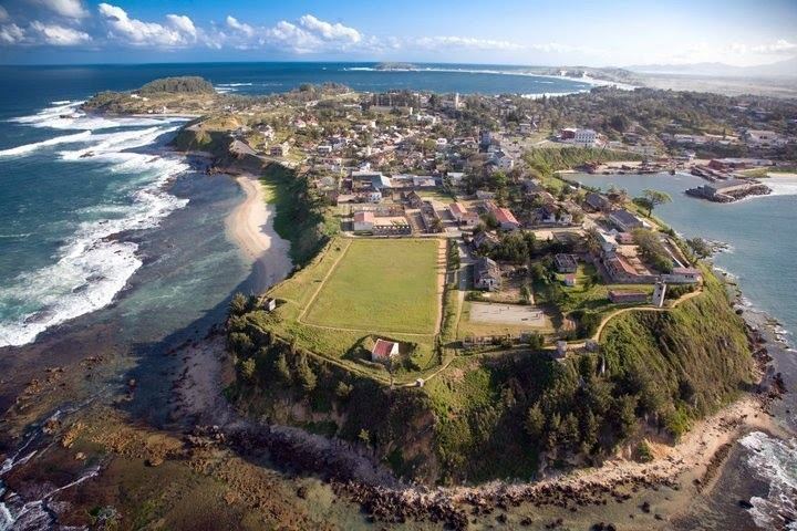
The unhealthinefs of the air [at Manafiafy] carried off [as in killed], in the space fpace of one month, the third part of the new fetlers. Pronis was forced to give up this infant colony, nothwithftanding its peculiar advantages of locality. He retired precipitately with the furviving fettlers, to the peninfula of Tholanger, where the air is more falubrious.... This peninfula widens imperceptibly; it may eafily be blocked up with redoubts and pallifades, to fcreen it from any incurfion of the part of the iflanders. The fort which has been erected here commands the road; its elevation is 150 feet above the level of the sea; an enemy who would come to anchor here, could not hold out the fire from the batteries which command the road. A fteep declivity furrounded by rocks render the landing difficult, and to approach the fort would be quite impracticable, if fome ftrong works were added to it. This fort, called Fort Dauphin is a long fquare, encompaffed with good walls of lime and gravel, and extremely well cemented; it was thought ufelefs to fhut it from the fide of the road.
1643-73 - Several different French Governors of Fort Dauphin, France's first colony in the Indian Ocean, sought to conquer Anosy, mounting multiple military campaigns through the south where they pillaged and then burned hundreds of villages, killed thousands of Malagasy, enslaved others and stole tens of thousands of cattle as they sought to wrest control of the area from the Zafiraminia kings. During this time the French colonialists living there also fought for several of the Malagasy kings in Anosy. In addition to the French settlers fighting the Antanosy, they also mutinied against their leaders, sometimes with the assistajnce of the local inhabitants. Fort Dauphin was a rough place to live. According to one source:
With the exception of some officers who feared God, there was neither order nor justice in the quarter of the Europeans. The most atrocious robberies were committed with impunity. The cattle of the natives was taken by force: they were massacred without mercy, when they did not give it cheerfully: they treated as an outrage upon temporals, the representations and complaints of a conduct so contrary to justice and humanity.
1643 – Fort Dauphin community began exporting ebony, hide and beeswax.[25] Initially they found the local Antanosy, ruled by Dian Ramaka (who had learned Portuguese and been baptized during 3 years studying at a Saint Paul's College, Goa), friendly, in part because many of the local inhabitants were descendants of shipwrecked sailors. In settling first in Manafiafy and then moving south to a sandy peninsula at a site known by the Antanosy people as Taolagnaro ("the place of many bones"). Both of these attempted French settlements were at the edge of the Zafiraminia's world. Pronis renamed the site Fort Dauphin, in honor of the then crown prince of France, the Dauphin (who became King Louis XIV.
Pronis married into the Zafindraminia Rohandrian. However, he soon had soon so angered his colony that they placed him in irons until he was rescued by Roger Le Bourg who arrived with 43 more men for the colony. Pronis seized 12 of those who had led the revolt against him, shaved their heads and banished them, along with several Malagasy women, to the island of Bourbon.
Pronis next angered the Antanosy people when he sold several of the Lohavohitz (wealthy and powerful bourgeoisie) class of people as slaves (they were sent to the Dutch Governor of Mauritius who had stopped in Fort Dauphin looking for slaves). Hearing of this, Pronis' time as Governor was ended by those in France.
1644 - Gallions Bay. Wreck of Le Saint Louis Compagnie Française de l'Orient.
1646 - First wave of initial settlers of Reunion, a roughly equal number of French and Malagasy who were sent there from Fort Dauphin due to their rebellion against the French East India Company.
1648 - King Ndriampanolahe of Arindrano joined forces with King Angeleaume against the village of Vohitsa Angombo, stealing 1,800 cattle. King Ndriandramaka of Fanjahira failed in his attack of Fort Dauphin. Ndriandave and Leroy first fought Zafy Lavatana then Zafy Andrenavolo, capturing its king Ndriantsimamelona who was speared by Ndriandava.
Etienne de Flacourt arrived in Fort Dauphin and took over as Governor from Pronis. He was the best educated of the colony's governors during this period of time, writing two fundamental books about Madagascar. While he was not quite as brutal as Pronis, he continued to conduct raids of the Antanosy for supplies as he was poorly supplied from France. His plan was to establish 9 different colonies in Madagascar, each of them able to be a supply for ships. In addition they would sell indigo, tobacco, sugarcane, hides, etc. to various markets around the world, the income from this used to support the colonies. As there was plenty of food being grown in the area surrounding Fort Dauphin, it could be obtained either through trade or if necessary, by force. Flacourt was a man of many skills, which included writing a very detailed explanation of Anosy at that time. He also learned to read the Sorabe [form of Arabic] script of the Zafirimania people.
Dian Iseronah was a local Antanosy prince at that time who commanded up to 6,000 warriors.
The Tranovato was still as originally described by Father Mariano in 1613, a 10m square blockhouse made of stone that was 3.5m high with 1m thick walls. It has doors on the western and eastern walls along with a series of rectangular apertures in each of the walls. In 1613 it had a carved sign which said "REX PORTUGALENSIS" and the tomb of a shipwrecked captain who'd died there. There were also several wooden houses outside the fort. It was built on a terraced hill (Pearson, 1997). For a 1656 map of the community at Tranovato created by Flacourt, see.
1648 to 1694 - First Congregation of the Mission (Lazarist) in southeast Madagascar, sponsored by the Society of St. Vincent de Paul. For a list of the Lazarist mission from 1648 to 1661, connected with events which occurred in Fort Dauphin environs, see Galibert (2007, pp. 127–128). For more information on work by the Roman Catholic Church in Anosy during the 16th and 17th centuries, see Roman Catholic Diocese of Tôlagnaro.
1649 – 12 Mahafaly emissaries came to Fort Dauphin requesting French mercenaries to help in a battle they were having with the Mashicoro who were stealing Mahafaly cattle. 15 of Flacourt's troops fought for Dian Manhelle with 2,000 of his troops against one of his rivals, and in just 12 days captured 10,000 cattle and 500 slaves. Returning to Anosy with 600 cattle, they were ambushed by Ramaka and several other roandria. However, all but one soldier arrived safely back at the Fort (due to reinforcements which accompanied them back).
The Antanosy and Zafindraminia finally obtained political union under Dian Ramack, formerly a Matikassi prince who had several years of Jesuit education in Goa. Identifying Fort Dauphin as an obstacle to his reign, he, along with his fellow Rohandrian fought the French for supremacy. Most of the peasants fled into the forests due to the violence.
According to Flacourt:
the Ombiasa [royal practicers of magic] employed [their services] against the French...they sent near the French fort baskets full of papers with printed symbols and writing on them, eggs...with [the same], unbaked earthen post with writings inside and out, small coffins, dugouts, oars...all covered with symbols, scissors, tongs... In short, there is hardly anything they did not try, even the poisoning of [our] water wells
Extensive destruction of villages close to Fort Dauphin led by Flacourt. For example, a detachment of 80 Frenchmen destroyed the town of Ifarantsa, 25 km from Fort Dauphin.
For a map of Fort Dauphin at this time, see For a map of the Anosy region at this time, see
1649 - Angeleaume led an expedition into the Manambolo valley, where they stole 500 cattle and gained a better understanding of the geography of this area. Later that year Leroy and Angeleaume lead another expedition where they capture 500 slaves and steal 10,000 cattle, sheep and goats.
The Mahafaly king Ndriamanelo made an alliance with Flacourt against the Masikoro king Ndriandravalo.
mid-1600s – Rise of Zafiraminia rule of the Efaho valley as they became the key connection between the French and the rest of Anosy. At the same time, the Zafiraminia sought to drive out the French using a variety of methods. The situation in Anosy was very unstable, not as much between the ZafiRaminia "blanche" hierarchy (Rohandrian) who provided the kings and the "noirs" (tompontany) who made this possible for them, but due to many armed conflicts within the Rohandrian lineage of those qualified to become king. In so doing they were seeking to maximize their support by the "blancs" and especially the powerful voadziri "noirs" (lohavits) village chefs. Insofar as the "noirs" weren't very happy that they simply were asked to choose the "blanc" chef, they tended to prolong this process, resulting in long periods of conflict and anarchy between the "blanches" lines. The end result was no stable, centralized control of Anosy.
While 77 Antanosy had been baptized, two missionaries had died, at least one from fever. There were no priests there until 1654.
As the European ships anchoring in the bays along the Anosy coast were heavily armed with cannons, muskets and pistols and the people in Anosy at that time had only a total of 9 flintlocks, they remained dominant as long as they didn't go very far inland.
1651 – The Antanosy briefly took over control of Fort Dauphin. After Flacourt was able to drive off thousands of Antanosy, led by king Ramaka, who attacked the fort, he killed Ramaka and one of his sons and burned down his village of Fanjahirambe, which was the center of the Zafiraminy. An archeological dig conducted in the early 1990s at this site found European stonewares, earthenwares, glass bottles, Far Eastern green glaze and blue and white porcelain (Wright et al., 1993).
1652 - The East India Company's 10 year concession expired without having been renewed.
1653 – Flacourt reinscribed the marble stone the Portuguese had used to mark their captain's grave at the Trano Vato and brought it to Fort Dauphin. On the marble he wrote, "Oh newcomer, read our advice: it will be useful for you, yours and your life: beware of the locals. Farewell."
Flacourt used his 100 soldiers, with their tremendous advantage of weaponry, to mount multiple punitive expeditions against the locals.
Dian Ramack and many of his fellow Rohandrian had been killed by Flacourt's forces. Other chiefs submitted (mifaly) to Flacourt.
Flacourt attempted to return to France for supplies (the last ships had been in 1650), but was forced to return to Fort Dauphin after 20 days at sea due to contrary winds.
1654 - First ship from France since 1650 arrives.
Second wave of what became some of the first settlers of Reunion, a roughly equal number of French and Malagasy who were sent there from Fort Dauphin due to their rebellion against the French East India Company.
Father Bourdaise, having traveled inland to Ranomafana, baptized 600 and translated a Catechism and the first draft of a dictionary that Flacourt later edited.
1655 – Flacourt returned to France for 5 years, where he published his extensive history of the Anosy region. That same year Fort Dauphin was burned down, not to be rebuilt again until 1660.
Pronis, who had arrived back in Fort Dauphin as an officer on an arriving ship, was again offered the position of Governor of Fort Dauphin. He accepted, to disastrous results, including his death from TB later that year.
A priest and 3 brothers who had just arrived in Fort Dauphin, ventured into Anosy, but were captured and imprisoned by the Antanosy who were very upset due to the death of their king. Captain La Foret was also assassinated.
1656 - Company was reconstituted, with the Duc de Meilleraye holding the major shares. He sent several ships to Madagascar between this year and 1663.
Fort Dauphin, having survived the death of several of its residents, carries out severe reprisals.
Ramaka's son Andriampanolahy rebuilt Fanjahira, which had become a symbol of Antanosy resistance to French colonialism.
'La Case,' a French soldier arrived in Anosy and before long married a soon to be heiress from northern Anosy. He soon became a local military hero.
1657 - The Petit Catechisme is published by Flacourt in Paris, followed in 1658 by his l'Histoire de la Grande Isle Madagascar, the Dictionnaire de la langue de Madagascar and a description of events at the colony in Fort Dauphin.
1660 – Having been appointed Governor of Madagascar, Flacourt sailed for Madagascar, but drowned in a shipwreck on June 10 (a 2nd edition of his book l'Histoire... was published the following year). The East-India Company appointed Chamargou to succeed him. Upon his arrival, he found the French had executed two roandria, but the Fort had been burnt down by the Antanosy and Pronis was dead. In response Champmargou began to reubuild the fort and led a ruthless attempt to conquer the local Antanosy, which only left those living in Fort Dauphin more isolated.
Le Rochelais Le Vacher, also known as M. Lavacher, Lacase or La Case, was single-handedly responsible for the conciliation between the Antanosy and the French. La Case, Champmargou's subordinate, having married the daughter of a roandriana and became a local ruler. After successfully fighting in wars against both the Mahafaly and the Karembola (Antandroy), he organized an army of Antanosy soldiers who saved Campmargou and his troops in a revenge attack they were trying to do because of the death of one of the Catholic priests who had insulted Dian Manana, a powerful local roandria. Many of the French died from malaria, including Chamargou.
La Case led a series of campaigns at Matitana, resulting in the overthrow of the Zafikasimambo.
1661 - Flacourt becomes the first European to describe the ravinala tree which he called "la plante du balisier," writing "The plant is quite beautiful to see because it grows in the form of a plume, and its fruit in a great trochet like dates" (p. 38)
1663 – On Christmas Day, 4 Malagasy adults and 15 children were baptized into the Catholic faith, but another missionary died soon thereafter.
1664 - The second French East India Company, called La Companie Orientale, under the leadership of Jean Baptiste Colbert, at the time the head of France's Financial Department, obtained all the concessions made to the first. Madagascar was renamed Eastern France.
1665 – With glowing accounts of Madagascar from returning ships, M. de Beausse was sent out to be the new Governor-General in one of four ships sent that year to rebuild Fort Dauphin. They arrived from France with almost 500 settlers who were "to establish there a civil society with original inhabitants." While these new settlers didn't include very many farmers, they did include carpenters, shoe-smiths, cabinet makers, masons and stone-cutters, cartwrights, gardeners, labourers, wine growers, bakers, butchers, tanners, candle workers, etc. (Ray, p. 85, 1979). However, due to an unclarity of roles, there was much internal fighting among the French settlers.
Worsening relationship with the local Malagasy resulted in it becoming quite difficult for the French living in Fort Dauphin to obtain rice or meat, their staple foods. As a result, they took possession of 3 different "posts" elsewhere in Madagascar to supply rice to Fort Dauphin. These included Fort Gaillard in Fenoarivo Atsinanana, which at one point shipped 158 barrels of rice and 500 birds to Fort Dauphin. A second site was located at Antongil Bay. Cattle, on the other hand, were obtained by raiding the countryside surrounding Anosy, which only worsened relationships with the people of Anosy.
Thousands of new colonists and troops arrive, many who died from warfare with the people of Anosy or fever.
The Compagnie's poor profits resulted in the Crown taking it over.
1667 – 10 ships delivered 2,000 colons and soldiers to Fort Dauphin, resulting in the remaining Antanosy rulers giving up their struggle with the French.
By the time nine new missionaries, 4 lay brothers and 2 farmers from the Recollects (Recollets) order arrived in Fort Dauphin, it had a chapel, monastery and library.
1668 – Fort described as having two "bastions" on the north side which commanded the harbor, was 50 feet long by 26 feet wide with a main door which overlooked s small meadow to the west while the other door looked east towards the sea.
1669 - M. le Comte de Mondevergue arrived in Fort Dauphin as Governor-General or Viceroy of Eastern France.
1670 – Poor management of the royal company's finances resulted in it sending out Delahaie as the new Governor-General. He appointed Champmargou, a former Governor as his second in command. La Case, though having been appointed Major of the Island, was not listened to. 200 remaining colonists left at Fort Dauphin living in a war-torn, hostile part of Anosy. Delahaie ended up leaving Fort Dauphin with his troops for Surat.
A letter from Roguet, one of the Lazarist community, back to France reports:
War continues, famine has not left, our weakness increases.... As our enemies, they increase their forces every day in number and in force...we are not in a position to defend ourselves, not having the arms, men, munitions of war nor the guns."
1671 – Death of both Champmargou and La Case, both killed by Antanosy. Both La Case's daughter and widow soon married other Frenchmen while M. de la Bretasche, La Case's son-in-law, also left for Surat.
Admiral de la Haye, who had temporarily taken over control of Fort Dauphin from Chamargou in 1660, but then had left for Réunion, disgusted by what he found there, told King Louis XIV he should abandon Fort Dauphin.
Rochon () described the reputation of those at Fort Dauphin as follows:
At this period it was well known that the islanders breathed nothing but vengeance against us, and eagerly sought an opportunity of retaliating for our injustice and oppression. Our yoke was become odious and insupportable to them. Historians, for the honour of civilized nations, ought to bury in oblivion every detail of the atrocious cruelties exercised against these people whom they brand with the odious epithets of barbarians, traitors, and thieves, because they have revolted against some European adventurers, whose least crime was a violation of the sacred rights of hospitality.
Dubois, a visitor to Anosy, described local Malagasy graves as being covered with gold or silver arm rings, along with coral and cloth in preparation for the deceased's next life (as cited in Pearson, 1997).
1672 - On Christmas Even, many of the French living in Fort Dauphin, gathered for a midnight mass at a church outside the walls of the fort, were massacred, their bodies dumped down what as known as Flacourt's Well.
1674 – Father Etienne poisoned, having served in Fort Dauphin for 8 years.
Wreck of the ship La Dunkerquoise of the French East India Company in the Fort Dauphin harbor which was on its way to Île Bourbon (Reunion) with quite a few young French women aboard who convinced the governor they should marry his colonists instead of going on to Bourbon. The governor ordered the colonists to do this and renounce their Malagasy wives.
August 27 - Feeling betrayed, these colonists' now former Malagasy wives told the local Malagasy forces about what had happened, who viewed this as a breaking of the colonists' alliances with them. 75 of the colonists were killed by the Antanosy while they were celebrating their marriages to the recently arrived French women.
September 9 - Fort Dauphin was evacuated and the fort and settlement closed (La Bretesche oversaw the burning of the remaining stores, the cannons being spiked and the magazine blown up). The survivors were evacuated to Mozambique India and Bourbon (now Reunion).
The departing French colonists left behind about somewhere between 2,500 and 4,000 French colleagues who had died there in the last 30 years, most from malaria, famine or violent death, a bitter French perspective of this region and a colonial failure, as the Antanosy had successfully forced them out. This was a source of French embarrassment for the next 200 years until France successfully took control of Madagascar in 1895, based at least partially on claims France made on Madagascar in the mid-1800s due to their time in Fort Dauphin.
While only 2 of a total of 37 French Catholic missionaries sent to Fort Dauphin by that time were able to return to France, by the time they left there were hundreds of baptized Antanosy, a French-Antanosy dictionary and a Catechism in the Antanosy language left behind.
After the massacre of so many of Fort Dauphin's colonists, Andrianarivo, son of Ravelomanor, fled north as he feared reprisal from the French.
1681 - While many French considered the abandoned Fort Dauphin to be too dangerous a stopping point to use for the next 60 years, the Soleil d'Orient of the French East India Company, stopped there for repairs in November. However, she was surprised by a cyclone, and though she was able to leave the bay, she broke up somewhere northeast of Pointe Itapère (Evatraha), with all hands lost.
1697 - The John and Rebecca, a US privateer from Boston, commanded by Abraham Samuel, a mulatto from Martinique, as it sought to return to the US having fled a Malagasy uprising on Isle St. Marie, sank near Fort Dauphin after hitting a reef. Abraham Samuel, with the support of this fellow pirates, briefly became King of the Anosy region, taking the name "Tolinar Rex." However, he died several years later.
18th century:
Continued conflict as the Zafiraminia attempted to regain control, without success. Size and number of settlements decreased and moved further inland from the floodplains and rivers towards the mountains. New crops introduced and a great deal of imports from China. Towards the end of this phase the traditional clay cooking ware were replaced by imported pots made of iron (Rakotoarisoa, 1998).
1701 or 1703 – The East Indiaman, Degrave, on its way back to England from India, about to sink, is run aground on the southern shores of Androy, possibly south of Ambovombe or less likely near Faux Cap. More than 150 crew, passengers and Arabs who were taken aboard in Mauritius to help with pumping out this leaking ship made it ashore and were captured by the Antandroy king, Decrindo. Warned the king planned to kill them, they took him, his wife and eldest son captive and set off towards Fort Dauphin, which was about 100 miles away. Only about 30 survived the trip to Fort Dauphin where they stayed until they were able to leave on Dutch ships in 1705 and 1706. For an in-depth explanation of this, see and
1725 - Small corvette Ressource, commanded by Captain Boulanger, went to Fort Dauphin to salt meat and load up animal fat, rice, woven pandanus and coffee, returning to Bourbon (Reunion) as soon as loading was completed.
1730s? - Revolt in Anosy against the Zafindraminia, resulting in their loss of their cattle (though Grandidier indicated this happened in the 1770s).
1740s – Another unsuccessful attempt by French to settle Fort Dauphin. As trade through Fort Dauphin began to increase again, the primary exports were cattle hides, salt beef or live livestock exported to Mauritius. Slavery was not an important trade.
1768 – Frenchman Count Louis Laurent de Maudave, a friend of Voltaire, former soldier in India and Mauritius planter, sent by the Ministry of the Duc de Praslin, attempted to rebuild Fort Dauphin, at least in part so it could be a supply base for the French colonies on the Mascarene Islands (Réunion, Mauritius and Rodrigues.
Finding 35 different rulers between the Ambolo valley and the Mandrare river, the most powerful only in charge of just 3,000 people, many at war with each other over cattle and slaves, Maudave signed 30 treaties with local kings as he didn't want to gain land through conquest. By this point, at least some of the local Malagasy viewed the French as allies, who, because they provided them with muskets and ammunition, allowed them to gain wealth and power. Maudave's plan was to close the fort and instead set up a French trading settlement at "Franchere," (along the Fanjahira river), where he had been given 10 leagues in length of land. However, the French government soon abandoned this effort, so he was forced to leave in 1769. While he was initially opposed to slavery, he ended up engaging in it to pay off his own debts and resupply plantations he owned in Ile-de-France (Mauritius).
1769 - Before the French left Fort Dauphin, they introduced prickly pear cactus to southern Madagascar. Over time it became a very important part of cattle-raising across the south.
Between 1768 and 1769, French traders from Mauritius in Fort Dauphin sold 10,000 guns, 50 tons of gunpowder, 120,000 lead shot bullets, 300,000 gunflints, 24,000 knives and 10,000 small mirrors. They were most likely purchased through bartering both India Rubber and slaves. At this point in time a slave could be purchased in some parts of Madagascar for 2–3 muskets. It is quite possible that at least some of these guns were traded by Antanosy with the Tandroy for cattle which the Antanosy then traded with Europeans. Arms retained by the Antanosy were later used in their unsuccessful defense of Anosy from the Imerina army which came south in the early 1800s.
1769 – Spiny prickly pear cactus Opuntia dillenii is brought from Mauritius with the aim of shielding the settlement; over the next 100 years, it spread over 50,000 square miles of the arid south from the Mandrare river and west throughout the Androy region, providing fruit to eat, a source of water and improved ground cover and ground water.
Boucher ("the butcher"), a cattle merchant from the Mascarenes, arrived in Fort Dauphin where he initially served as Chief Surgeon. When this colonial attempt failed, he remained in Madagascar for another 10 years, serving the royal government of the Ile de France. He died aboard Elephant, the ship that transported cattle to Ile de France when it ran into a cyclone (p. 372).
1770 - Under order of King Louis XVth, French Navy stopped this settling project and Fort Dauphin was again abandoned by Maudave in 1771, who took Malagasy slaves with him back to his Mauritius plantation.
About the time of the departure of the French from Fort Dauphin, the Zafiriminia kingdom also fell. While at the time of the establishment of Fort Dauphin in the mid 1600s, though Anosy was one of the most densely populated part of Madagascar, it produced considerable agriculture surpluses and was on the verge of being unified into an important Malagasy kingdom. This in very sad contrast to how a French visitor viewed it shortly after the collapse of the Maudave colonial effort in 1770 when it was seen "as the 'poorest' and 'saddest' in the island, barely populated and virtually without 'resources.' Even slaves and cattle were few in number and had to be brought from far away" (p. 885).
1771 - In a letter written by Philibert Commerson he wrote:
What an admirable county is Madagascar! it is the veritable promised land for naturalists. It is there that Nature seems to have retired as into a special sanctuary, to work there on other models than those to which she enslaved herself in other countries.
1775 - Geographer Gareau de Boispreaux, an aid to Benyowsky, aboard the Coureur, spent several months studying Madagascar's southern coastline and Fort Dauphin.
Navy flute La Fortune, with men and supplies for Benyowsky's settlement at Maroantsetra (Antongil Bay), lost its anchor and ran ashore in Fort Dauphin bay where it broke apart.
1776 - French corvette Sirene, with 60 men and supplies also for Benyowsky's settlement at Maroantsetra, was wrecked near Fort Dauphin due to navigation error. While only 10 mean drowned, they had almost no arms, so when attacked by Malagasy warriors, they were robbed and then separated and sent to various villages. Eventually freed, they gathered at Fort Dauphin to await rescue but by the time they were picked up and taken to Mauritius several months later, most, including the Captain, had died from illnesses.
1798 – HMS Garland (Captain Wood), part of a small British squadron sent to challenge French ships in the western Indian Ocean, seeking to identify a French vessel anchored off Manafiafy, was wrecked about 5 miles northeast of St. Luce island. All survived, taking the French over as prisoners from the Malagasy who were holding them. They were rescued several months later by the sloop Star, who took everyone to South Africa. While waiting ashore, Captain Wood surveyed the coast between Fort Dauphin and Manafiafy.
19th century:
1811 – Jean Rene, son of a French settler of Fort Dauphin and an Antanosy mom, became Governor of Toamasina, first under British and then under the Imerina king Radama I's rule. He took a blood oath with Radama in 1817 and was a powerful ally, even against the Antanosy, until his death in 1826.
1819 – Albrand, a trader originally from Marseille, reopened Fort Dauphin in the name of King Louis XVIII of France, having negotiated with the Zafiraminia king Rabefania who reassured Albrand the past was forgotten. Rabefania was also interested in French protection from the Imerina monarchy, led by king Radama I, who was seeking to conquer the whole of Madagascar.
By this time the Antanosy people were also seeking a way to respond to their increasingly despotic princes ("Rohandriana").
The French reoccupation of Fort Dauphin provided protection to a small number of French traders workig along the coast.
Fort Dauphin continued to export cattle, but also became a slaving base for larger slaves ships. A considerable rum distillation was also developed to serve the ships.
(Rakotoarisoa, 1998).
1825 – Moving down the east coast from Mananjary, Anosy, including Fort Dauphin, was conquered by 3,000-4,000 soldiers, led by Ramananolona, cousin of King Radama I of the Imerina kingdom, after a battle at Masihanaka, near Eboboka. On March 14 the Imerina entered the French fort, subdued De Grasse, the French Commandant, replaced the French flag with that of the Imerina kingdom and Ramananolona was suddenly head of the commercial establishment at Fort Dauphin (the French fled to an island off of Manafiafy, from which they were picked up and taken to Bourbon). Ramananolona was the first Imerina governor of Fort Dauphin until he was executed on orders of Ranavolona in 1828. In taking Fort Dauphin, Radama had control of the entire eastern coast of Madagascar.
After the majority of the conquering troops left, the fort was held by a garrison of 800 Imerina who were armed with muskets and Sakalava troops, armed with assaygaies, who lived outside the fort.
The Imerina there included voanjo (colonists) who settled there, protected by the above soldiers who used Fort Dauphin as their rova, a fortified area with some similarity to the Imerina palace in Antananarivo.
Having confiscated the Antanosy guns, the Imerina demanded cattle, taxes, slaves and forced labor (adults were forced to create and farm rice fields while children were required to protect rice crop from birds and sugar cane from rats). From this point on there was Antanosy resistance by Rabefania's soldiers, which was brutally suppressed by Rafito, who commanded the Imerina troops. This resistance continued till the French conquered the Imerina, meaning most of Anosy was not controlled by the Imerina kingdom, but rather only Fort Dauphin, its neighboring town of Andrahomana and Manafiafy, where they collected duty on exports and imports.
1827 – Jean Laborde's ship runs aground north of Fort Dauphin during a cyclone. He makes it ashore and is captured by Antanosy, at the same time becoming, per Queen Ranavalona I's royal decree, a royal slave. He made his way north and ended up significantly impacting the Imerina kingdom of that time.
1830 - While the Rohandrian monarchy totally disappeared within Anosy, other than in the memory of the Antanosy, their benefits in terms of pasture for their cattle and their best ricelands remained. Thus the "blanches" became known for their cultivation of rice while the "noirs" were known for their raising of tubercular crops of manioc and sweet potato.
1836 - The Margaret Oakley, returning from a trip to the east was forced to anchor in Fort Dauphin bay when it was discovered rats had eaten through six of its water casks. While building new casks, the ship lost an anchor chain in a sudden gale which came up and was driven ashore.
Two hundred Malagasy villagers had collected on the beach, all willing to lend a hand, and the captain got them to form a chain reaching form the vessel to the shore, some in boats and canoes, others standing in the water. The Malagasy soon landed the cargo, but "amid a scene of great confusion," with "many a box of costly silks, satins, crapes, and handkerchiefs ornamenting different parts of their persons, while under their arms were boxes of tea, bundles of sewing silk, and other valuables the like of which the natives had never before seen." Morrell [the ship's captain] "paced the beach to and fro like a maniac, with a brace of pistols in his hands, threatening to blow out the brains of the first man who broke open a box. But he was not ubiquitous, and the moment he turned his back, open went a box, and away ran the ... contents." The captain could only despair, his vision shattered and his kingdom sunk. His frown and cold command were now directed at those who, antlike, emptied his colossal wreck, now destined for the sandy depths. He could not police the chaos, and he lost a fair amount of cargo to the "helpers." A hundred bottles of medicinal cajuput oil that he had purchased in Singapore were "lost," while the sago he had also acquired was ruined by seawater. Once the cargo was unloaded, and the crew were ashore, Morrell put the chests and crates under armed guard and secured them with tents made from the ship's sails. In all, Morrell claimed officially to have saved 115 of the 400 full tea chests, 230 of the 450 half tea chests, and 380 of the 630 tea boxes--that is about 40 percent of the tea cargo. He also recuperated 360 cases or boxes of silks, which was by his estimation about half the total. Three cases of chinaware, a case of ink, and eight cases of pearl shirt buttons were also among the items recovered. It was the boxes of curiosities gathered from around the Bismarck Sea, however which were to cause the most trouble. Some of these chests had drifted ashore at the foot of the bay, and when an inquisitive Malagasy opened one, he was more than shocked to find it stuffed with dried skulls [which Captain Morell had stolen from villages on the islands of Arawe (New Britain) earlier in his voyage, as he felt they would sell well in New York and Philadelphia when he got back home to the US]. As Jacob writes, the Malagasy were horrified and "held a convention over them, and concluded that the crew of the Margaret Oakley were a set of piratical cannibals, who had been cruising along the shores of Madagascar, eating the people and preserving their skulls. This came near causing a bloody outbreak of savage fury upon our party, and it was only by consummate tact on the part of the captain that the enmity of the natives was allayed." (pp. 257-258)
Morrell eventually managed to get what he had left of his cargo on a British ship bound for England (not the US as would have made more sense), not wanting to face growing suspicions of the owners and insurers of his voyage who were facing massive losses by this time.
By this time very few ships were coming into Fort Dauphin because of fear of Queen Ranavalona's rule, in part as she had dismantled treaties with both Britain and France and in part because Fort Dauphin was the base from which her military forces were conducting "ruthless campaigns" (p. 258) against the Antanosy people.
1845 – First wave of 30,000 Antanosy moved west, eventually to the Onilahy River valley near Betioky and Bezaha to escape Imerina rule.
1850 – Unsuccessful Imerina attempt to invade Androy by means of a coastal attack near Faux Cap ends with a retreat to Fort Dauphin.
mid-1850s – Leather craft skills introduced by artisan missionaries of the London Missionary Society in the highlands spread to Anosy when those Imerina skilled in this area fled Imerina "fanompoana" (forced labor). At this time some Antanosy also become part of the specialized porterage system of the Imerina kingdom, returning to Anosy with their earnings after completing their contracts.
1852 – Six month siege of Fort Dauphin by the Antanosy which was finally broken by Imerina reinforcements sent by Lambert who broke through to the town. A report from the Imerina Governor of Anosy a year later indicates that while 47 Imerina soldiers had died in taking over the region, they had killed almost 3,000 Tanosy. This resulted in Fort Dauphin becoming more of a garrison town and Antanosy no longer attending worship in the church in town.
In response to unceasing repression and atrocities by the Imerina, an estimated 80,000 Antanosy, led by king Zaomanery, first moved to Androy (which the Imerina hadn't been able to conquer), but faced with thefts of cattle, wives and children by the Antandroy, eventually moved further west to join the previous Antanosy in the Onilahy river valley. Unfortunately, these Antanosy were faced with raid of their livestock by the Bara and Mahafaly people of that area. They felt further threatened when the Imerina were able to conquer Toliary. They also struggled regarding ethnicity, resulting in separate leaders for the Zafitomany versus the Zafiramania peoples.
1855 - Joseph Lambert, a Mauritius trader-planter, who replenished Fort Dauphin's supplies using his vessel, as they were blockaded by land by rebels in the southeast.
1869 – Ranavalona II, Queen of the Imerina, became a Christian, requiring her representatives around the country to build churches. Some time after this a church was built in Fort Dauphin by the Imerina living there, who eventually made attendance mandatory for those living in Fort Dauphin.
1872 – Marchal, a Creole merchant from Mauritian, arrived in Fort Dauphin and eventually became the dean of the foreign community there. He established a combination botanical garden and experimental cash crop plantation which he named the Jardin de Nahampoana, just north of Fort Dauphin, a site which remains to this day (see Nahampoana Reserve).
mid-1870s - Money still not in use in most of Anosy.
1880 – Two Malagasy Christian evangelists were sent by the London Missionary Society to Anosy and began to work with the church there, eventually taking over leadership of it.
1883 – Beginning of war against the Imerina kingdom in the Antananarivo region. Tanosy revolted against Imerina and briefly took over control from the Imerina in Fort Dauphin.
1884 – king Tsiamanana, who had replaced king Zaomanery as head of some of the Antanosy living in the Onilahy river valley, refused to submit to the Imerina general Rainimavo.
Imerina troops retook control of Fort Dauphin.
1885 - A French cruiser bombarded Fort Dauphin, forcing the evacuation of the Imerina there.
year? – French Bocard brothers established a coffee and rubber plantation at Manantantely.
1887 – Imerina lost control of Antananarivo, resulting in the Antanosy no longer respecting their rule in the Anosy region.
Rev. Nielsen-Lund of the Norwegian Missionary Society (NMS), together with Malagasy porters and guides, traveled down to Fort Dauphin through Bara country (where they were twice imprisoned by different kings) for a second time at the request of the NMS, to identify the best way for the Hogstads, the first Lutheran missionaries to work in this area, to travel on their way down from the highlands. After only one day's rest in Fort Dauphin, he returned to the highlands by going straight north from Fort Dauphin to Vangaindrano, which was the way the Hogstads then came down a year later.
Nielsen-Lund estimated there were 500 troops of the Imerina Kingdom, many of them Betsileo, living within the fort itself. Outside the fort was a small Tanosy settlement, with 3 white traders living south of them. He indicated the Imerina control of this area extended 2 days walk to the southwest, 5 days walk to the north and several days walk into the interior.
The Antanosy population was described as "very scattered" at this point in time, ruled by about 30 feudal kings.
1888 – The Imerina post at Fort Dauphin included 421 people, 343 soldiers and 78 family members. Fifteen men and 16 women were nobles or officers, with the Governor having 13 honors. The soldiers had almost 100 Snider repeating rifles as well as over 160 other rifles.
Having spent over 6 weeks traveling down from Antananarivo to Ihosy and then east to the coast and down from there, American Rev. John and Lena Hogstad arrived in Fort Dauphin, accompanied by the Rev. Nilsen-Lund of the NMS, for whom the Hogstads worked, who helped them with their journey and to settle there. At this point in time northern Anosy, through which they traveled as they came south from Vangaindrano, was a fairly lawless place.
Fort Dauphin had 12 Europeans living there, all of them traders with formal government agreements with both the English and French.
Rev. Hogstad and his wife began work on establishing a Lutheran church in Anosy, work which eventually expanded to encompass all of Anosy, Androy and the Mahafaly regions, with significant numbers of American Lutheran pastors, evangelists, educators and medical staff working in southern Madagascar for the next 100 years. However, having been sent with the blessing of the Queen of Imerina, they were asked to start working with an existing Imerina congregation located just outside the Fort in the midst of where the Imerina lived. While they were supported by the Imerina Governor in these efforts, this support meant they were viewed as collaborators with the hated Imerina by the Antanosy.[27]
1889 – Ramananjo (12 honors) succeeded Rainimiarana as Imerina in charge of Fort Dauphin.
First 7 Antanosy youth baptized by Rev. Hogstad. Shortly thereafter the Hogstads began a Lutheran school especially for Antanosy youth, purchasing the liberation of Rabenjamina, a young local slave who'd been taught how to read and write in Antananarivo, who became the first teacher. Before long Hogstad had also started an evangelist training school, though 8 of the 10 first students were either Betsileo or Imerina. Before long Hogstad had established Lutheran churches in Evatraha (1889), Mandromondromotry (1890) and Mahatalaky (1893).
1890 - Catat, who passed through Fort Dauphin, described it as primarily an Imerina garrison town, inhabited by Imerina soldiers and their families.
1891 – Caoutchouc discovered in western Anosy, much of it coming from the Manambaro region, and within one year 1,680 tons were exported by German and Swiss (Jenny) houses of commerce.
1892 – London Mission Society ended their work in southern Madagascar, having handed over leadership of the Fort Dauphin congregation to Rev. Hogstad.
1893 - Rev. Isolany, American Lutheran missionary, began to establish <<Efa-polo lahy>> ("40 men") secondary and <<Roambinifolo lahy>> ("12 men") primary schools in Anosy. Jesuits established schools in Soanerana and Manambaro, already considered "bastions" of Protestantism by this time.
1894? – Tandroy drove Europeans out of two small coastal trading-stations (Andrahombe, 20 km southwest of Fort Dauphin and Antanambazaha, at the mouth of the Mandrare), stealing their stores. These sites were probably trading for rubber and a lichen from which red or violet dye could be obtained, but neither was ever reestablished by Europeans after this.
1894 – John Waller, an African American who'd just retired as the American Consul in Tamatave, was given 225 square miles of land near Fort Dauphin for a rubber plantation by the Imerina Prime Minister Rainalivarony. While he advertised for settlers to come to this site, he never actually visited it himself, having been arrested by the French when they took over Madagascar in 1895, eventually giving up his claim to this land.
Lotsen, a Norwegian ship, sunk in the Fort Dauphin harbor with a load of rubber.
1894-95 - French Catholic missionaries in Anosy were forced to leave due to Franco-Malagasy war.
1895 – Central and northern Madagascar conquered by France.
In March, a European trading station which had existed at the mouth of the Mandrare river for the past 3 years, was overrun by Antandroy who plundered all the stores there, including Procter Brothers'.
Permanent Catholic Missions started in Fort Dauphin, led by Paulist priests and the Sisters of Charity.
Lutheran missionary Miss Nilsen established a boarding school for girls in Manafiafy.
(Rakotoarisoa, 1998). (For additional information about France's colonial efforts, see French colonial empire.)
1896 – On August 6, Madagascar was colonized by France due to the signing of the Annexation Act.
French took control of Fort Dauphin, almost 350 years after they'd left in defeat from their first attempt to do this. First Resident was Capitaine Brulard who initially only had control of Fort Dauphin and Manambaro, with a great deal of insecurity in the rest of the region to the detriment of both Malagasy as well as foreign merchants seeking to export rubber. The French set up outposts in Manantenina, Tsivory and Manambondro, but had to abandon both Tsivory and Manambondro when they were attacked.
The "grand" king of Anosy, Rabefagnatrika, reigned over the interior of Anosy, headquartered in Fanjahira. He was a rival to Rabefially, who was king of Manambaro and pro-French. Raosinty was the last king of the Antatsimo, based in Ranopiso, with an interest in increasing his territory, for which reason he was permanently in conflict with the Zafiraminia kings (the Andonak' Atsimo from Ranopiso vs. the Andonak' Avaratra from Fanjahira). He was exiled by the French to Isle St. Marie in 1904.
Fort Dauphin's Fremch Resident underwent a atihena ("blood brotherhood") ceremony with King Malay of Manambaro and his two brothers, Simanihsa and Zahalo.
Apostolic Vicariate of Madagascar established Apostolic Vicariate of Southern Madagascar. St. Vincent de Paul Catholic parish established in Fort Dauphin. Monseigneur Crouzet visited Saonierana, Manambaro and Ranopiso (see Roman Catholic Diocese of Tôlagnaro for more information on the work of the Roman Catholic Church in Anosy.).
Rubber exports dropped to only 168 tons as instead of being harvested, the plants were pulled out by their roots.
Rev. Hogstad and his wife established a second Lutheran Mission Station at Manantenina. In the next 10 years additional Lutheran Mission Stations were opened up in Manafiafy (1898), Tsivory (1900), Manambaro (1908) and Ranomafana (1909).
1897 – General Gallieni, now in charge of Madagascar for France, reintroduced the Merina royal fanompoana, "compelling every able-bodied Malagasy male between the ages of 16 and 60 to furnish 50 days of unpaid labour a year" (p. 240).
France established a Military Circle Annex which divided the region into 3 sections, Antandroy, Antatsimo & Antanosy as they sought to have better control of the area. This included establishing a military outpost in Ampikazo, 30 km west of Fort Dauphin, to assist merchants working on rubber exports, but this was attacked by the Tatsimo of that area who burned the village down. In retaliation the French captured Tatsimo King Rahosinta, sent him to Reunion where he became a laborer and fined the Tatsimo people 500 cattle, created a head tax and set up posts in both Elekelaka and Manambaro.
France began to allot up to 2,000+ hectares concessions to large companies, all of them run by Europeans or Creoles. These eventually included about 30% of the most fertile land in Anosy.
Mr. Marchal tests the growing of Bourbon and Liberia coffee at Nahampoana test gardens.
Monseigneur Crouzet visited Ifarantsa, Fanjahira, Hazoambo, Isaka Ivondro, Enaniliha, Ranomafana, Mahabo, Ampasimena and Manantenina as part of Catholic missionary efforts.
Missionary Rev. Skaar established a Lutheran school for boys in Fort Dauphin. This was later moved to Manantantely.
American Lutheran Mission exchanges land French colonial government wanted just north of what is now the Fihaonana Lutheran Church for the point they named "Lebanon" (now called Libanona) which they developed into a retreat and R&R center for Lutheran missionaries who came in from stations eventually located across southern Madagascar.
1898 – Southern Madagascar (including Fort Dauphin area) conquered by France using Colonel Hubert Lyautey (General Gallieni's second in command) "tache d'huile" method which he had successfully invented for us in Indochina, a counter-insurgency method still being used today (population is surrounded by military outposts). The French disrupted both the Imerina rule as well as that by Zafiraminia princes.
Head tax of 5 francs/man over 16 years old imposed, in part to force Malagasy to grow more crops in order to pay taxes. Failure to pay meant either forced labor or imprisonment.
Senagalese soldiers were sent down from Tananarive to stop Tatsimo raids of neighboring villages. They successfully fought the rebels and confiscated their cattle.
July 31 - Wreck of the French cruiser Lapérouse in Fort-Dauphin's Bay :assigned to the French colonial government and hoisting General Gallieni's pennon in a second circumnavigation of Madagascar,she loses her anchors in gusting winds and runs aground.
1899 – Sisal first mentioned as a possible cash crop.
20th century: Also see
early-1900s – The Compagnie Agricole et Industrielle de Madagascar (CAIM) planted 500 hectares of Sisal on a 2,550 hectares concession they had received next to Lac Anony near Andranobory. The Tatsimo (see Antanosy) and those Antanosy living in the Tsivory area were soon in revolt of the French, to the point that the French captured the Tatsimo king Rahosinta who was deported to Reunion.
Pierre de Bellier de Villentroy, a Frenchman living on Reunion who was an uncle of Alain and Henri de Heaulme, began mining Mica near Tsivory, which he exported through Fort Dauphin.
1900 – Having conquered Anosy, the French set up 16 posts in the region which they'd divided into 3 ethnic sectors. They invited French settlers to farm the fertile lands in the Isaka and Fanjahira valleys (as Flacourt had envisioned). Malagasy were subjected to taxation and forced labor which was used to build roads and establish plantations, greatly increasing the amount of arable land in Anosy.
1901 – French Lieutenant Colonel Lavoiseau forces Antanosy to unite under the leadership of just one person who was Fitory. Head tax increased from 5 to 20 francs/man over 16 years old. Failure to pay meant either forced labor or imprisonment. Roads were built from Fort Dauphin to the Mandrare river, Manambovo and Mahika in order to simplify the extraction of resources. Many Tatsimo moved to establish villages closer to these new highways.
Jenny (Swiss-German) family is one of the first from Europe to settle in Fort Dauphin, establishing a Swiss "house of business." Initially they exported 4-5 million French francs per year of Caoutchouc from Fort Dauphin. However, this only lasted several years as while 12 different rubber lianas were being collected for this, the plants were pulled out by the roots in their harvesting. Caoutchouc was also collected along the Mandrare river, with Jenny using barges to ship it to Fort Dauphin from where it was exported to Europe. Some of these exports were made into surgeon's gloves and some of the first Michelin tires.
1901 - Telegraph line is extended from Betroka to Fort Dauphin, completing this line for the length of the island.
1904 – Rebellion in Farafangana, the Bara, in Vangaindrano and by the Taisaka, by Malagasy seeking to recover their freedom fro French rule, spread to Antanosy, led by king Befanatrika, against French rule in Esira and Tsivory, where locally recruited soldiers working for the French government deserted their posts, as well as Isaka, Mahampoana, Manafiafy, Manambaro, Manantenina and Ranomafana results in many of the expatriates living in the Anosy region, along with many Malagasy Christians retreating to the rundown fort in Fort Dauphin. This lasted for 5 months, eventually put down by French with aid from their Senagalese soldiers. The region also suffered from smallpox and locusts at this time.
1905 – Estimated 120,000 Antanosy.
French Governor-General Augagneur's (1905-1910) anticlericalism resulted, including a campaign against Christian mission efforts, resulted in the revival of the Tranozozoro, with pastors demanding a "free church in a free country." Malagasy intelligentsia "stressed the national tradition of the Protestant faith whose democratic structures could become a refuge for the resistance" (p. 245).
Smallpox and locusts pass through Anosy.
1906 – Three areas of land in the fertile Efaho valley near Soanirana, Isaka and Ifarantsa, covering over 4,000 hectares had been seized by the French for colonial plantations.
The French, assuming Malagasy Lutherans had led the revolt, shut down all of the Lutheran schools and churches in Anosy. Schools were not reopened until missionaries from France came to reopen them.
At about this same time Pierre de Bellier de Villentroy (Frenchman living on Reunion, an uncle of Alain and Henri de Heaulme) established a Mica mine near Tsivory, which he exported through Fort Dauphin to Europe.
1907 – Forced labor (prestations) introduced for all men over 16 years old. This was used to provide labor on colonial plantations, at mica mines, to build roads, schools and hospitals and to do reforestation. Men could be taken for 30 to 60 days of work.
1912 – First major drought of French colonial period.
Mica was discovered in southern Madagascar, with a major mine north of Betroka. Exports before WWII ranged from just 18 tons in 1918 to a maximum of 819 tons in 1928., 138 in 1932 and back up to 677 in 1938, with most going to the US followed by France and Great Britain.
Lutheran Mission Station opened at Behara.
1913 – Major cyclone damages infrastructure which was followed by drought and then famine.
Roman Catholic church's Apostolic Vacariate of Southern Madagascar becomes that of Fort-Dauphin.
1914 – Just over 25 years after the arrival of the first American Lutheran missionary there was a total of 16 missionaries working in Anosy (with 8 more arriving to join them by 1917), 2,741 baptized and 2,511 students in Lutheran schools. By 1930 another 27 American Lutheran missionaries had arrived to replace missionaries who had returned to the US, died in Madagascar and to help expand work in Androy.
1917 – Colonial government had Tatsimo near Ranopiso clear large areas in order to grow cow peas, castor oil beans and other legumes.
1919 – Major flu epidemic followed by drought in 1920.
1920? - Marthe de Heaulme, sister of Alain and Henri, arrived in Fort Dauphin as a Catholic novitiate, becoming Sister Gabrielle of the Daughters of Charity, eventually founding and heading 3 different religious communities in southern Madagascar.
Alain and Henri de Heaulme moved south from what was then called Tananarive to work on Pierre de Bellier de Villentroy's mica mine near Tsivory, where Alain became manager.
1922 – Major cyclone severely damages road from Fort Dauphin to Behara.
1924 - Serious efforts began to turn over the leadership of the Lutheran church in Anosy to Malagasy leadership.
1925 – Cochineal insect introduced into southern Madagascar by Botanist Perrier de la Bathie. In five years it spread across southern Madagascar, causing severe famine and loss of cattle in Androy, resulting in many Tandroy moving into Tatsimo lands.
Leprosarium established by Catholics at Ampasy.
1926 – According to E (1992):
Faced with the resistance of the Malagasy to any form of recruitment [for forced labor], the [French] administration took over and, in 1926, established the Service de la Main d'Oeuvre pour les Travaux d'Interet General (SMOTIG), which required conscripts not actually called up for military service to work for three years--subsequently reduced to two years--on the colony's construction sites. The SMOTIG, which was regarded by the Malagasy as being "slavery in disguise," was deeply resented not only by the people who commandeered but also by "voluntary" wage labourers who lost their jobs as a result. (p. 242)
In addition, the French government forcibly took the land it wanted, which it then distributed to their "colon" settlers. In addition these "colon" then took additional land they wanted, meaning Malagasy no longer owned even their ancestral lands. This especially happened in the northwestern and eastern coastal areas.
179 Europeans were exploiting 2,170 hectares for various crops, for an average of 12 hectares/European while 88 Malagasy (many of them not from Anosy), were farming 528 hectares (25% that of Europeans), for an average of 6 hectares/Malagasy.
1927 – Head tax increased from 25 to 40 francs/man over 16 years old. Failure to pay meant either forced labor or imprisonment.
1928 – With the growing of sisal "outsourced" from Mexico to Africa, the Societe Fonciere du Sud de Madagascar plants a trial sisal plantation on part of the 2,000ha of land they had been given near Ranopiso, about 40 km west of Fort Dauphin.
Henry de Heaulme, 29 years old, arrived in Fort Dauphin, having driven down from Tananarive in a Harley Davidson motorcycle with his wife and son in the side car. His intent was to export mica and sisal from Androy and western Anosy through Fort Dauphin.
1930s - French began working in the Anjahamiary area (near Tranomaro). Swiss mining company, Hibron Freres, began mining phlogopite and hibonite deposits, where they discovered Tourmaline, which they mined until 1975.
1930 – Another 27 more by 1930.
1932 – The Societe Fonciere du Sud de Madagascar planted a 4,000 hectares of sisal in the Mandrare valley near Amboasary, about 75 km west of Fort Dauphin. [For information about sisal production in the Mandrare valley, see Guerin (1969?).] This same year the 11th natural reserve of Andohahela, starting with 30,000ha but growing to its current total of 76,000ha, was created by the French colonial government. It is located 40 to 80 km from Fort Dauphin.
1933 – Mica extraction in the Fort Dauphin district which employed 140 women and 30 men in extraction from Ampikazo, splitting in the towns of Ranopiso, Ankaramena and Soanirana and washing and weighing at Manantantely expanded to 5,000 women splitting 621 tons in 1938. However, by 1944 it was of little importance.
First year of what became a 5-year drought.
Ranopiso sisal plantation had grown to 1,000ha in size, stretching south almost to the coast, but only lasted from 1933 to 1938 due to soils and labor being inadequate for this, resulting in only 67 tons of sisal being harvested in 1935. It was shut down with all sisal efforts moved to the Mandrare valley.
Construction of a dam to expand farming near Behara.
1936 – The first sisal plantation near Amboasary is established by Établissements Gallois. Henri de Heaulme established his sisal plantation and the Berenty forest reserve.
1940 – Madagascar officially remains under Vichy France authority.
de Guitaut family, based out of Fort Dauphin, starts local growing and production of tobacco as none can be imported.
1942 – Madagascar invaded by British forces who replaced Vichy France's control with that of the Free France Government in January 1943 (but Diego-Suarez naval base, in 1945)
While the British handed over control to General Paul Legentilhomme, the defeat of Vichy France in Madagascar by Great Britain, who remained in country until 1946, deeply damaging French colonial prestige in Madagascar.
While Mica was mined in western Anosy continued to be exported from Fort Dauphin to both sides of conflict, sisal production fell due to a lack of imports.
1943 – Some Tandroy refugees from the famine in Androy fled to Fort Dauphin, though having nothing when they got there, some of them died there.
1945 – Expansion of irrigated farming near Behara results in quite a few people moving here to work.
While the hated French colonial indigenat system of forced labor was finally abolished, Malagasy nationalists nationwide campaigned for independence from France.
1947 – Tsivory Catholic parish established.
1948 – Beginning of lobster production in Anosy.
1949 - Very heavy rainfall in Anosy between May and July floods crops.
1951 - Cyclone passes through the Anosy region on January 29–30.
1950s–60s – Boetchi (Swiss), de Heaulme and Jenny families and the Lyonnaise and Marseillaise companies exported wild beans of Castor oil plant, cattle (10,000–30,000/year), mica and sisal. Henry de Heaulme began his conservation efforts by establishing a nature (including lemurs) reserve on his sisal plantation on the Mandrare river.
1954 – Establishment of Manambaro Hospital, some 25 km west of Fort Dauphin, by Lutheran Mission.
1955 – Societe Fonciere du Sud de Madagascar (SFSM) developed 130 hectares of rice fields and planted 25,000 coffee trees on their remaining 260 hectares concession near Ifarantsa. They had earlier planted 2,175 hectares of coffee near Ranomafana, having abandoned 800 hectares of attempted sisal near Ranopiso as well as a 182 hectare coconut plantation at Lokaro.
The Apostolic Vicariate of Fort-Dauphin becomes the Diocese of Fort Dauphin.
Amboasary Catholic parish established.
1956 - 138,000 Antanosy.
1956-57 - Just outside Amboasary Sud, bestriding the Mandrare river at a 15m height, Paindavoine Sarl launch, by the incremental method, a 414 m long, design-improved and appropriate, licensed Callender-Hamilton bridge. Holding up the steel girders - six 69 m long spans - the massive reinforced concrete 5 piles and 2 abuttals (some of them, on compressed air-caisson foundations) were erected by Anciens Ets Eiffel, who designed the work. The Direction Générale des Travaux Publics de Madagascar was the Owner and the Construction Supervisor. It was financed by FIDES credits (public investments' fund of the French Union Overseas Ministry) for 400 million fCFA (around US$2 million). The Pont du Mandrare provides the first all-year-long road link between the Anosy and Androy regions (RIG 13).
1957 – Just outside Fort Dauphin,is completed the SIFOR sisal weaving factory (assets 60 million fCFA Ets Vandesmet).Decorticated fibers from the Mandrare plants are processed into strings,cords,sacks and rugs(production 345t).
Three sawmills, owned by Jenny (at Bemangidy) and the Societe Sciere d'Ilandy (at Antsapa), along with another sawmill at Elandy were producing over 1,000 m3 of lumber/yr, much of it either precious or at least semi-precious wood.
1958 – Monja Jaona founded the Mouvement National pour l'Indépendance de Madagascar (MONIMA) party in the south, but it subsequently spread throughout Madagascar.
Henri de Heaulme becomes President of the Provincial Assembly and Vice-President of the National Assembly, urging independence for Madagascar. He is present with Philibert Tsiranana and Monja Jaona at the signing of the new constitution for the Malagasy Republic.
Eli Lilly begins development of cancer treatment drugs from Rosy Periwinkle, a plant indigenous to Madagascar which grows along the coast of southern Madagascar beginning at Ranopiso (western Anosy) to Beloha (western Androy), but by then found in several different countries, from which they were able to develop cancer treatment drugs that earned the company hundreds of millions of dollars. While Eli Lilly bought Periwinkle from several countries and even grew it in Texas, the best quality was from southern Madagascar.
1959 – 148,132 Antanosy. In the Mandrare valley, 6 companies were growing sisal, each with 2,000+ hectares planted, employing a total of 4,500 Malagasy.
(Rakotoarisoa, 1998).
1960 – Madagascar became an independent nation.
Second Catholic parish established in Tolagnaro.
1961 – SIFOR was producing 800 tonnes per year, half of which was exported to France and Reunion.
1963 – Between 1954 and 1963, 3,986 tons of highly radioactive Uranothorianite had been mined and exported to France.
1964 – Year of greatest sisal production from the Mandrare valley (almost 30,000 tonnes), having grown from just over 2,000 tonnes in 1950. France was the primary importer.
1965 – Population of Fort Dauphin is 11,800 and that of the Antanosy estimated to be 148,132.
Manantenina Catholic parish established.
1966 – Beginning of export of seaweed to Japan.
1967 – Due to the growing popularity of synthetic fibers, the price for sisal had dropped 50% since 1964.
1972 – First "industrial" plantation of Periwinkle, located near Ranopiso, with others located in Androy, starts large-scale exportation to the US and Europe.
1973 – Decreasing quality and unreliable exports of Rosy Periwinkle has Eli Lilly reducing purchases of it as they tried to grow it in Texas.
Trano Vato site excavated by the Malagasy Musee d'Art et d'Archeologie.
1974 – Beginning of the export of live lobsters from Anosy to Europe which was made possible in part due to beginning of 737 service between Fort Dauphin and Tananarive which connected with a flight to Europe.
Boom in exportation of Periwinkle, with 7 different firms involved.
1975 – Initial analysis of Ilmenite in Anosy conducted by US Steel which set up a very small pilot plant in Mandena. Cyclone Deborah damages much of Anosy, including Tolagnaro and Amboasary, knocking out electricity and water supply for several days.
1,200 tons of Periwinkle exported.
1978 – With worldwide demand for Periwinkle in decline, many of the companies involved in its exportation stopped doing this.
late 1970s – Demand for Periwinkle becomes so great that Eli Lilly again began purchasing it from large-scale plantations in Madagascar.
1980s – Anosy region becomes a high priority area for conservation efforts by international NGOs, resulting in the influx of a wide variety of foreign conservation experts (and some Malagasy), who began work in this area. SHTM created by de Heaulme which currently has 5 hotels in the Tolagnaro area plus the Berenty Reserve.
mid-1980s – Growth of Tolagnaro results in increased demand for charcoal for cooking, resulting in rapid deforestation of forests near Tolagnaro, Manantantely and the spiny forest east of Amboasary-Sud (this charcoal primarily produced by Antandroy).
1985 – World Wildlife Fund began working with the Andohahela reserve, conducting preliminary biological inventories, ICDP projects began in 1987 and USAID funding was obtained in 1990.
1986 – Henri and Jean de Heaulme family awarded the J. Paul Getty Award for Conservation Leadership for their conservation work in Madagascar. OMNIS and what became QIT Madagascar Minerals begin a 20+ year process which finally leads to mining of both ilmenite and ???. What was then known as QIT-Fer et Titane establishes an office in Tolagnaro and begins work in the Anosy region.
1987 - QIT first signed a joint-venture agreement with OMNIS to mine ilmenite.
1988 – Demand for Periwinkle increases to about 800 tons/year.
1989 – Diocese of Fort Dauphin becomes that of Tolagnaro.
1990s – Parts of Anosy and a reserve near Berenty (in eastern Androy) become major tourist destinations, causing rapid growth in the tourism industry in this area.
1990–97 – Andohahela national reserve project received over $4 million of funding.
Third Republic, led by Presidents Albert Zafy, Didier Ratsiraka and Marc Ravalomanana (1992–2009)
1992 – Initial exploitation of Sapphires found near Andranodambo, some 210 km from Tolagnaro (first seen by French in the mid-1600s, early 1800s and 1950s) in what was then a location where mica was mined.
QIT completes the baseline social and environmental study. In 1993 it renegotiated its contract with the Malagasy government, increasing its holding from 49% to 80% in what became QMM.
1994 – Cyclone Daisy passes through. Azafady starts working in Anosy. Later that year Andrew Lees dies of heat exhaustion in the Petriky forest, just west of Tolagnaro, while researching the potential impacts of the mining of Ilmenite in the Anosy region. The next year the Andrew Lees Trust was established, with an office set up at Libanona (just outside Tolagnaro), to develop and implement social and environmental education projects across southern Madagascar.
1995 – 300 tons of seaweed per year exported to Japan.
1996 – Anosy region is identified as one of the ecologically most diverse regions of Madagascar.
1997 – Cyclone Gretelle passes through.
1998 – 20,500 passengers disembark at Tolagnaro airport.
1999 – 24,800 tourists visit Anosy.
21st century:
2000 – Of the 15,000 tourists who visit Anosy, 7,000 of them visit Berenty.
Cholera outbreak in Fort Dauphin from February till February 2001.
2004 – Between 1988 and 2004, about 800 tons/year of Periwinkle are exported, employing over 7,000 people in both Anosy and Androy,with another 15,000 supported through kin networks. Due to the rising value of growing food in central Anosy, most Periwinkle production in this region occurs in the southwest. Unfortunately, exporters receive 22 times what is paid the peasant producers.
2005 – World Food Program responds to malnutrition in Anosy caused by a combination of drought and flooding.
World Bank announced Taolagnaro is one of the three sites funded for its Integrated Growth Poles project.
2006–08 – QMM created over 4,400 jobs, 61% local hires, 10% expatriate.
2007 – Over 500,000 people now living in Anosy. In addition, Malagasy from all over the island, Europeans, North Americans, Filipinos, French, Japanese and South Africans all living in Tolagnaro while working on the QMM projects, filling up all the hotels for the next two years, ruining most of the tourism business in Anosy.
2007 – Malagasy government helps to organize the Tambazotran' ny Vehivavy Mpitarika amin' ny Fanitra Anosy (TVMA), Women Leaders' Network in the Anosy Region, with the objective of improving women's capacities in society.
Major Syphilis outbreak in Toalagnaro. State of Emergency is declared with up to 17.000 people (30% of the sexually active population) being infected.
2008 - QMM begins mining ilmenite from its brand new mine just outside Tolagnaro, but first shipment not sent until mid-2009.
2009 – Port d'Ehoala is completed and QIT Madagascar Minerals begins to export Ilmenite through it to Canada for processing after over 30 years of exploration and studies and several years of construction of the port and mining facilities. With the completion of construction, the vast majority of foreign personnel were repatriated.
January - Some Ampasy Nahampoana residents barrricaded the main road to the mining site in Mandena due to a dispute over the value of land they were offered., resulting in losses of up to $1 million per day.
2010, November - Hundreds of Malagasy again block the road between the mine and the port, protesting the lack of work opportunities at QMM for educated Antanosy.
Fourth Republic led by Mr. Andry Rajoelina (2010–present)
2011 – QMM begins to temporarily provide electricity to Tolagnaro.
1,000 claimants from Anosy filed a class-action lawsuit in the UK against Rio Tinto, but this collapsed when Rio Tinto was able to settle out of court with some of the claimants.
2012 - Increasing lawlessness by "dahalo" (bandits) in the regions of Anosy northwest of Ranomafana all the way up to Betroka results in over 100 bandits being killed by vigilante groups.
Aziana Ltd. of Australia estimated bauxite resources at Manantenina project to be 10.1 million metric tons at a grade of 34.1% aluminum oxide (Al2O2).
Just north of Rio Tinto’s St. Luce (Manafiafy) ilmenite site a Chinese-owned ilmenite-mining concession was working to obtain permission to start mining.
2013 - QMM's mining road again blocked by Malagasy unhappy with high unemployment in spite of the mine's operation (local charges that only 10% of the employees are local, while QMM argues it was 70%), alleged political corruption and unsatisfactory reimbursement for relocating homes to make room for the mine. As a result, QMM announced they would not be developing the St. Luce (Manafiafy) site.
South African Cruise ship MSC Sinfonia spends four days in Fort Dauphin.
2014 - Tolagnaro's coast identified as seriously threatened by coastal erosion due to "rise in sea level, landslides, and coastal erosion" (p. 148), with up to 9m loss of beach width at Vinanibe, potentially due in part because of dredging done for the Ehoala port.