
Intercommunality Pays Savinois Area 8.81 km² | Population (2009) 324 Local time Sunday 1:43 AM | |
 | ||
Weather 4°C, Wind SE at 8 km/h, 79% Humidity | ||
Property for sale in the france near to annepont poitou cha
Annepont is a French commune in the Charente-Maritime department in the Nouvelle-Aquitaine region of southwestern France.
Contents
- Property for sale in the france near to annepont poitou cha
- Map of 17350 Annepont France
- Blaireaux d terr s acca annepont
- Geography
- Toponymy
- Administration
- Demography
- Distribution of Age Groups
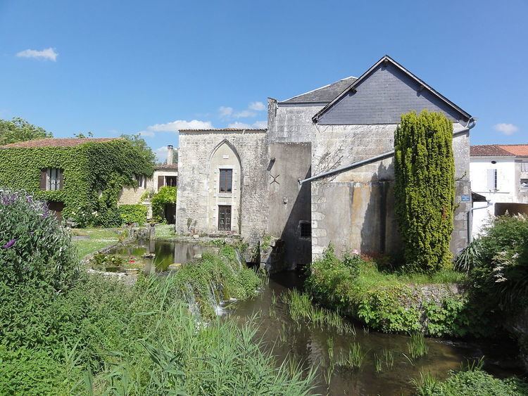
- Civil heritage
- Religious heritage
- Railway Stations and Halts
- Airport and aerodrome
- References
Map of 17350 Annepont, France
The inhabitants of the commune are known as Annepontois or Annepontoises
Blaireaux d terr s acca annepont
Geography
Annepont is located some 15 km south-west of Saint-Jean-d'Angely and 13 km north of Saintes. The A10 autoroute (E5) passes through the west of the commune but has no exit in or near the commune. Access to the commune is by the D127 from Taillebourg to the south-west passing though the village and continuing north to Mazeray. The D230 road also goes east from the village to Juico. The D231 also passes through the south of the commune forming part of the southern border and continues to Écoyeux to the south-east. The commune has extensive forests in the east covering some 40% of the land area with the rest of the commune farmland.
The Ruisseau de la Blanchardiere rises in the east of the commune and flows west joining with numerous other streams.
Toponymy
Toponymists do not mention an old form for this place name so that the etymology of Annepont remains hypothetical. Albert Dauzat saw a compound of the elements Anna, a Germanic personal name, followed by the Gallo-Roman Ponte (from the Latin pons) meaning "bridge".
Ernest Nègre agreed on the nature of the second element -pont but interpreted the first in a radically different way: it is possibly the local term asne meaning "humpbacked" - i.e. "humpbacked bridge".
N.B.: There is a Germanic personal name Anna which is unrelated to the Hebrew personal name Hanna(h) (giving Anna then Anne). This anthroponym is an hypocoristic Germanic anthroponym beginning with the element Arn-. The final a rather indicates a Saxon origin. This hypothesis is supported by the existence of a number of place names in the region (notably in -ville) so the first element could be a Saxon anthroponym. In addition, archaeological excavations confirm the presence of Saxons in the region. This far south a compound structure is expected rather than the Romanesque *Pontanne but Annepont is more reminiscent of a toponymic type of northern France marked by Germanic influence and made from a Germanic anthroponym as for Radepont, Senarpont, Hubertpont, Carlepont, etc. The solution advocated by Ernest Nègre, if possible phonetically, is even more hypothetical inasmuch as an ancient form of the type *Asnepont is required.
Administration
List of Successive Mayors
(Not all data is known)
Demography
In 2009 the commune had 324 inhabitants. The evolution of the number of inhabitants is known from the population censuses conducted in the commune since 1793. From the 21st century, a census of communes with fewer than 10,000 inhabitants is held every five years, unlike larger towns that have a sample survey every year.
Sources : Ldh/EHESS/Cassini until 1962, INSEE database from 1968 (population without double counting and municipal population from 2006)
Distribution of Age Groups
The population of the commune is relatively old. The proportion of persons above the age of 60 years (26.2%) is higher than the national rate (21.6%) while being less than the departmental rate (28.1%). Like the national and departmental allocations, the female population of the commune is higher than the male population. The rate (50.9%) is of the same order of magnitude as the national rate (51.6%).
Percentage Distribution of Age Groups in Annepont and Charente-Maritime Department in 2009
Sources: