
Elevation 110 m Population 41,008 (2010) Named for Annandale | Area 20.36 km² Area code Area codes 571 and 703 | |
 | ||
Neighborhoods Woods of Ilda, Annandale Acres, Wilburdale | ||
Welcome home to the shithole of annandale va
Annandale (Gaelic: Srath Anann) is a strath in Dumfries and Galloway, Scotland, named after the River Annan. It runs north-south through the Southern Uplands from Annanhead (north of Moffat) to Annan on the Solway Firth and in its higher reaches it separates the Moffat hills on the east from the Lowther hills to the west. A 53 mile long-distance walking route called Annandale Way running through Annandale (from the source of the River Annan to the sea) was opened in September 2009.
Contents
- Welcome home to the shithole of annandale va
- Map of Annandale VA USA
- Update on annandale situation can i crash on your couch
- History
- References
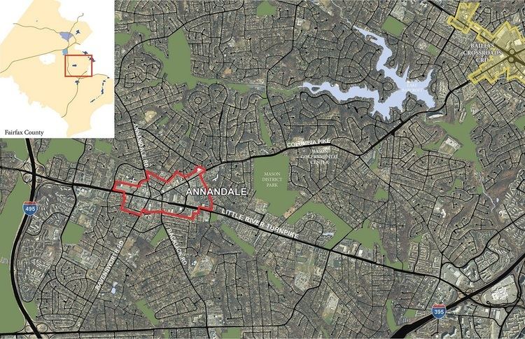
Map of Annandale, VA, USA
Update on annandale situation can i crash on your couch
History
Annandale was also an historic district of Scotland, bordering Liddesdale to the east, Nithsdale to the west, Clydesdale and Tweeddale to the north and the Solway Firth to the south. The district which was in the Sheriffdom of Dumfries and later became part of the County of Dumfries, one of the counties of Scotland. The main reorganisation took place during the Local Government (Scotland) Act 1889, which established a uniform system of county councils and town councils in Scotland and restructured many of Scotland's counties. (See: History of local government in the United Kingdom). It is one of three subdivisions of Dumfriesshire, along with Eskdale (previously part of Liddesdale) and Nithsdale.
It is famous for its connection with Ben Johnson and Robert the Bruce, as the de Brus family was given this land by David I in 1124, as one of the border lordships when David became Prince of the Cumbrians. Along with Carrick, these lands acted as a buffer between the quasi-independent Lordship or Kingdom of Galloway and David's lands of Strathclyde and Cumbria.