
Time zone CET (UTC+1) Population 247 (1999) | Intercommunality Garazi-Baïgorri Area 12.33 km² | |
 | ||
Canton | ||
Anhaux (Basque: Anhauze) is a French commune in the Pyrénées-Atlantiques department in the Nouvelle-Aquitaine region of south-western France in the former province of Lower Navarre.
Contents
- Map of 64220 Anhaux France
- Geography
- Localities and hamlets
- Toponymy
- History
- Administration
- Inter communality
- Demography
- Economy
- Languages
- Civil heritage
- Religious heritage
- Environmental Heritage
- Notable people linked to the commune
- References
Map of 64220 Anhaux, France
The inhabitants of the commune are known as Anhauztar.
Geography
Anhaux is located some 2 km west of Saint-Jean-Pied-de-Port and some 10 km south of Ossès. Access to the commune is solely by country roads branching from the D15 road passing to the north of the commune. The commune consists of farmland in the north with the southern part more rugged and hilly.
The commune is located in the drainage basin of the Adour. The Ontzeroneker erreka' - a tributary of the Nive d'Arnéguy - with many tributaries rising in the commune forms the southern border with Lasse commune. A right tributary of the Berroko erreka, the Aparraineko erreka flows down from the Artzaïnharria (971 m).
Localities and hamlets
The Napoleonic land registry divided the commune into 16 districts in 1840:
Heguy was an old district, extending that of Choubitoa.
Today, the following localities are listed:
Toponymy
The commune name in basque is Anhauze.
Brigitte Jobbé-Duval proposed a basque origin of ona-oz, meaning "place of the hill".
The following table details the origins of the commune name and other names in the commune.
Sources:
Origins:
History
Anhaux village is one of eleven hamlets or villages which were in the Baigorry Valley. In the Middle Ages, the eleven hamlets were: Ascarat, Sorhoeta, Moussourits, Lasse, Irouleguy, Urdos, Leispars, Occos, Oticoren, Guermiette, and Anhauz, all in the north of the valley. The south was not populated until much later. Despite sounding Basque, the name of this village seems to defy all analysis. The oldest document known on which the name Anhaux appears is now the cartulary of the abbey of Saint-Jean of Sorde where it appears in the 10th century.
Father Haristoy in his book Research on the Basque Country noted that recorded in this cartulary were:
The Benedictine Abbey in question was founded in the 9th century north-east of Navarre. It was, as with all the monasteries at the time, a vast agricultural area spread along the mountain streams in Orthe country and lower Navarre and, according to the two cited references, in the parish of Anhaux.
It was around 1023 that King Sancho III of Navarre founded the fief of the Viscounty of Baigory in favour of Garcias Lop who was related. The creation of the hamlet itself, on the viscounts' lands, therefore dates back to this period. Thus from the 11th century the status of houses at Anhaux was defined by the writer Jean-Baptiste Orpustan. He provided a list of houses existing in the Middle Ages in Anhaux. This document was created from the archives from 1350, 1366, and 1412.
Of the twenty-eight houses found there, four were noble (only the house was noble and so the owners were considered as such), the others were fivatiéres which means that they paid a fee in crops, work, or money and were built on the land of the "Lord" of the main house.
The successive Viscounts of Baigorry then of Echaux enjoyed the tithes of the village until their liquidation in 1792.
The arms Anhaux are those of the Apesteguy family. They were adopted by the municipal council on 30 July 1993. Pierre Haristoy wrote that the Apesteguy were lords of Jaureguia and of Anhaux and nominated the priest for the area. In deeds before 1670 several of the Apesteguy appear as noble. Towards 1720 Jean-Pierre d'Apesteguy was received by the States of Navarre. The house of Apesteguia was, until the 18th century, the Lay Abbey for the area. Its members played an important role in the valley until the end of the 19th century.
The Cassini map, made in the 18th century shows a parish consisting of:
Administration
List of Successive Mayors
(Not all data is known)
Inter-communality
Anhaux commune participates in eight inter-communal structures:
Demography
In 2009 the commune had 286 inhabitants. The evolution of the number of inhabitants is known from the population censuses conducted in the commune since 1793. From the 21st century, a census of communes with fewer than 10,000 inhabitants is held every five years, unlike larger towns that have a sample survey every year.
Sources : Ldh/EHESS/Cassini until 1962, INSEE database from 1968 (population without double counting and municipal population from 2006)
Economy
The commune is part of the Appellation d'origine contrôlée (AOC) of Irouléguy and also the AOC of Ossau-iraty. Economic activity is principally agricultural.
Languages
According to the Map of the Seven Provinces edited in 1863 by Prince Louis-Lucien Bonaparte, the basque dialect spoken in Anhaux is western Lower Navarre.
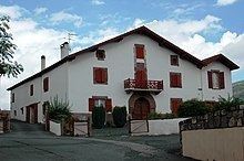
Civil heritage
The commune has a number of buildings and structures that are registered as historical monuments:
Religious heritage
The Church of Saint John the Baptist (Middle Ages) is registered as an historical monument. It was almost entirely rebuilt in 1838. Its cemetery has some Hilarri.
Environmental Heritage
Notable people linked to the commune
Jean Iraçabal, born in 1851 at Anhaux and died in 1929 (buried at Saint-Étienne-de-Baïgorry), was a decorated French military officer.