
Area 48.36 km² | Canton Salers Population (2009) 799 Local time Saturday 12:07 PM | |
 | ||
Weather 6°C, Wind N at 8 km/h, 48% Humidity | ||
How to pronounce anglards de salers in french pronouncenames com
Anglards-de-Salers is a French commune in the Cantal department in the Auvergne region of south-central France.
Contents
- How to pronounce anglards de salers in french pronouncenames com
- Map of 15380 Anglards de Salers France
- Beton imprime anglards de salers 15380 france www betonimprimeart fr youtube
- Geography
- List of Priests for Anglards de Salers
- Administration
- Demography
- Civil heritage
- Religious heritage
- Notable people linked to the commune
- References
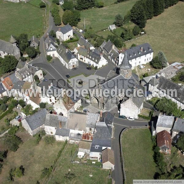
Map of 15380 Anglards-de-Salers, France
The inhabitants of the commune are known as Anglardois or Anglardoises
Beton imprime anglards de salers 15380 france www betonimprimeart fr youtube
Geography
Anglards-de-Salers is located some 60 km west by north-west of Saint-Flour and 15 km south of Ydes. It can be accessed by the D122 road from Mauriac in the west to the village. There is also the minor D22 road from Méallet in the north to the village which continues as a more major road to Salers in the south-east. The D222 road also comes to the village from Salins in the west. The D12 road from Veyrieres in the north also passes inside the north-eastern border of the commune and continues to Le Falgoux to the south-east of the commune. The D212 roads goes west from the D12 to the village. There are a number of small hamlets in the commune. These are:
Other than a belt of forest along the north of the commune, the commune is entirely farmland.
The Mars stream flows through the north of the commune from the east joined by the Ruisseau de Veysset in the north of the commune then continuing north to join the Sumene at Vendes. There is also the Auze stream flowing through the heart of the commune towards the west where it joins the Sione east of Escorailles. The Monzola also flows west in the south joining the Auze just west of the commune. Several other unnamed streams flow into these streams.
List of Priests for Anglards-de-Salers
List of Priests
(Not all data is known)
Administration
List of Successive Mayors
(Not all data is known)
Demography
In 2009 the commune had 799 inhabitants. The evolution of the number of inhabitants is known through the population censuses conducted in the commune since 1793. From the 21st century, a census of communes with fewer than 10,000 inhabitants is held every five years, unlike larger towns that have a sample survey every year.
Sources : Ldh/EHESS/Cassini until 1962, INSEE database from 1968 (population without double counting and municipal population from 2006)
Civil heritage
The commune has a number of buildings and structures that are registered as historical monuments: