
Canton Dozulé Area 3.91 km² Local time Saturday 11:40 AM | Region Normandy Intercommunality Pays d'Auge dozuléen Population 123 (1999) | |
 | ||
Weather 9°C, Wind S at 19 km/h, 70% Humidity | ||
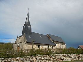
Angerville is a French commune in the Calvados department in the Normandy region of northwestern France.
Contents
Map of 14430 Angerville, France
The inhabitants of the commune are known as Angervillais or Angervillaises
Geography
Angerville is located some 30 km east by north-east of Caen and 20 km west of Pont-l'Eveque on the A13 autoroute which passes through the commune south of the village but has no exit in the commune. The nearest exit is Exit 29 to the west of the commune. Access to the commune is by the D675 road which runs parallel to and south of the A13 autoroute from Dozulé to Danestal. The D287 runs north from the D675 through the commune to the D142 which passes through the north-west of the commune running from Dozule to Gonneville-sur-Mer. Access to the village is solely by the dead-end Chemin de l'Eglise which runs west off the D287.
The Ancre river runs from west to east through the south of the commune and is joined by several other streams. The Ruisseau de Caudimuche forms much of the eastern border.
Administration
List of Successive Mayors
(Not all data is known)
Demography
In 2009 the commune had 137 inhabitants. The evolution of the number of inhabitants is known through the population censuses conducted in the commune since 1793. From the 21st century, a census of communes with fewer than 10,000 inhabitants is held every five years, unlike larger towns that have a sample survey every year.
Sources : Ldh/EHESS/Cassini until 1962, INSEE database from 1968 (population without double counting and municipal population from 2006)