
Area 14.27 km² | Local time Friday 12:12 AM | |
 | ||
Weather 9°C, Wind E at 13 km/h, 80% Humidity | ||
Angeac-Champagne is a French commune in the Charente department in the Nouvelle-Aquitaine region of southwestern France.
Contents
- Map of 16130 Angeac Champagne France
- Location and access
- Hamlets and localities
- Geology and relief
- Hydrography
- Climate
- Toponymy
- History
- Administration
- Demography
- Distribution of Age Groups
- Education
- Culture and heritage
- Civil heritage
- Religious heritage
- References
Map of 16130 Angeac-Champagne, France
The inhabitants of the commune are known as Angeacais or Angeacaises
Location and access
Angeac-Champagne is a commune located in the west of the department of Charente, near Charente-Maritime, in Grande Champagne, the premier cru of cognac.
The commune is located 10 km south of Cognac, 6 km west of Segonzac, and 3 km east of Salles-d'Angles. Angoulême, the prefecture of Charente, is 35 km to the east. Angeac is also 9 km north of Archiac, 12 km south-west of Jarnac, and 19 km north-west of Saint-Hilaire.
The commune does not lie on any main roads. The D731 road from Barbezieux to Cognac via Archiac, passes through the west of the commune. The village is served by the D150 from Germignac in the south-east and passes through the village before continuing north-east to join the D44 from Juillac-le-Coq to Roissac towards Cognac and Gensac-la-Pallue. A country road leads to the village of Salles-d'Angles and another to Genté in the north-west.
The nearest train station is at Cognac which is served by the TER between Angoulême, Saintes, and Royan.
Hamlets and localities
There are many hamlets dotting the commune. In particular Roissac, located northeast of Angeac village, was an ancient parish, and the village is as important as Angeac.
The small village of Le Bois d'Angeac together with a small forest is located 1 km north-west of the village.
Apart from a few small patches of forest the commune is entirely farmland
Geology and relief
As with the whole left bank of the Charente between Angoulême and Cognac, this area is limestone dating from the Cretaceous period with Cuestas.
The commune is part of the Campanian (Late Cretaceous) chalky limestone area which occupies a large part of South Charente. There is also some Santonian rock on a small part of the northern border at Longées.
The Campanian cuesta passes through the commune. This escarpment starts in the west at Salles-d'Angles, passes the foot of the town of Genté, then runs through the whole department going east towards Bouteville, Jurignac, and Plassac-Rouffiac. In the commune the escarpment passes through the east as an inlier northeast of Roissac. It separates the north of the plain of Châteaubernard from Champagne to the south.
The highest point in the commune is at an altitude of 84 m located north-west of Roissac. Another high point of 83 m faces it to the east (topped by an IGN Survey marker). The lowest point is 17 m located in Pas de la Tombe on the south-west edge of the commune near Salles d'Angles. The commune mostly varies in height between 40 and 70 m above sea level.
Hydrography
The Ruisseau de la Motte, a small tributary of the Né River and thus a sub-tributary of the Charente, forms the commune boundary to the south. No other rivers pass through the commune but there are many pools in a valley west of the village and towards Roissac and some springs including the Three Stones east of Bois d'Angeac.
Climate
The climate is oceanic Aquitaine.
Toponymy
The word Angeac is derived from the Latin Andiacum or villa Andii meaning that the village was built around the property of a rich Gallo-Roman named Andius. The term Champagne was added to the name of the town in 1801 to distinguish it from its namesake Angeac-Charente. In Saintonge the term Champagne refers to a fertile plain of limestone. It is derived from the Latin campus meaning "field" or "plain".
The word Roissac is derived from the Latin Riatacum or villa Riatii meaning that the village was built around the property of a rich Gallo-Roman named Riatus.
History
Proto-historic circular Ditches exist in the areas of Penchant de Lorimont and Houme, with square and circular ones at a place called Les Chirons. Roman villas are said to be at Puits d'Angeac at Chabanne and there are some medieval remains at Branges.
The remains of a Gallo-Roman villa possibly dating to the first half of the 9th century were found in 1904. It was a residence of Louis the Pious. These remains have disappeared.
Angeac was first a dependency of the Templars then passed to the Marquisate of Archiac then often changed hands. In 1239 Roissac passed to the House of Angoulême then at Barbezieux. By marriage Roissac became allied with Salles-d'Angles and Genté. The rights to the marshes resulted in brawls and lawsuits with the Lordship of Gademoulin.
The commune of Angeac was created in 1793 when it belonged to the Canton of Salles in district of Cognac and the Charente department. In 1801 it took the name of Champagne and was attached to the Canton de Segonzac.
The Roissac railway station was served from 1910 to 1939 by the Chemins de fer économiques des Charentes (Cheap Trains of Charente) with a metre gauge line from Cognac to Barbezieux with 3 return trips a day at a speed of 20 km/h. This line also served stations at Cognac, Genté, Segonzac, Juillac-le-Coq, Saint-Fort-sur-le-Né, Archiac, and Barbezieux.
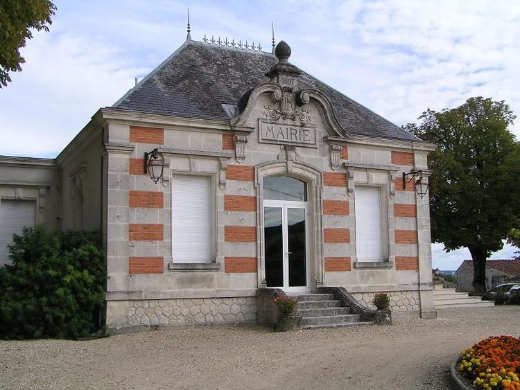
Administration
List of Successive Mayors
(Not all data is known)
Demography
In 2009 the commune had 510 inhabitants. The evolution of the number of inhabitants is known through the population censuses conducted in the commune since 1793. From the 21st century, a census of communes with fewer than 10,000 inhabitants is held every five years, unlike larger towns that have a sample survey every year.
Sources : Ldh/EHESS/Cassini until 1962, INSEE database from 1968 (population without double counting and municipal population from 2006)
Distribution of Age Groups
Percentage Distribution of Age Groups in Angeac-Champagne and Charente Department in 2009
Sources:
Education
The school is an educational inter-communal grouping between Angeac-Champagne and Salles-d'Angles. Angeac-Champagne has a kindergarten and Salles-d'Angles an elementary school.
Culture and heritage
The commune contains a very large number of buildings and structures that are registered as historical monuments. For a complete list with links to descriptions (in French) click here.
Some of the more interesting sites are described below.