
 | ||
Similar Boysen Dam, Alcova Dam, Wind River Canyon, Hot Springs State Park, Buffalo Bill Dam | ||
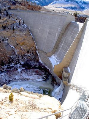
Anchor Dam is a dam in Hot Springs County, about 35 miles (56 km) west of Thermopolis, Wyoming.
Map of Anchor Dam, Pavillion, WY 82523, USA
The concrete thin-arch dam was completed in 1960 by the United States Bureau of Reclamation as a water storage project. The 208-foot (63 m)-high dam structure impounds the water of the South Fork of Owl Creek, with the spillway as designed as a central overflow "notch".
Unfortunately the reservoir never filled. During construction, the discovery of solution cavities in the bedrock forced the re-positioning and re-configuration of the dam, causing delays and added expense. The same karst solution cavities prevented Anchor Reservoir from filling its design capacity of 17,400 acre feet (21,500,000 m3). It has never been full. More than 50 sinkholes had been identified in the underlying Chugwater Formation geology of the reservoir basin, with at least one of them 30 feet in diameter and 35 feet deep. The site's lack of "hydraulic integrity" was well known to Bureau scientists before and during construction.
The reservoir fills enough to provide some irrigation benefit through July and August of each season. It's operated by the local Owl Creek Irrigation District.