
Country United States Time zone Mountain (MST) (UTC-7) Elevation 1,320 m Population 3,038 (2013) | State Wyoming Elevation~±500 feet 4,331 ft (1,320 m) Area code(s) 307 Zip code 82443 Local time Wednesday 11:57 PM | |
 | ||
Weather 7°C, Wind W at 10 km/h, 66% Humidity | ||
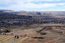
Thermopolis wyoming
Thermopolis is the largest town in, and the county seat of Hot Springs County, Wyoming, United States. As of the 2010 census, the town population was 3,009.
Contents
- Thermopolis wyoming
- Map of Thermopolis WY 82443 USA
- History
- Decline in mineral spring flow
- Geography
- Climate
- 2010 census
- 2000 census
- Tourism
- Education
- Postal Service
- Health care
- Highways
- Airport
- Notable people
- References
Map of Thermopolis, WY 82443, USA
History
"Thermopolis" (/θɜːrˈmɒpəlɪs/) is from the Greek for "Hot City". It is home to numerous natural hot springs, in which mineral-laden waters are heated by geothermal processes. The town is named for the hot springs located there.
The town claims the world's largest mineral hot spring as part of Hot Springs State Park. The springs are open to the public for free as part of an 1896 treaty signed with the Shoshone and Arapaho Indian tribes.
Thermopolis is also the home of the Wyoming Dinosaur Center, which hosts the only Archaeopteryx fossil outside of Europe.
Decline in mineral spring flow
In 1991, the Associated Press reported, in an article entitled "Hot Springs Rationed: Natural Wonder Drying Up:"
Geography
Thermopolis is located near the northern end of the Wind River Canyon and Wedding of the Waters, where the north-flowing Wind River becomes the Bighorn River. Thermopolis is ringed by mountains, with the Bridger Mountains to the southeast, the Owl Creek Mountains to the southwest, the Big Horn Mountains to the northeast and the Absaroka Range to the northwest. Thermopolis is the southern-most municipality in the Big Horn Basin.
Roundtop Mountain, on the northern edge of town, is a unique geological formation shaped much like a volcano. It sits at approximately 6,000 feet and is the highest area in the immediate vicinity of Thermopolis.
A large body of water, Boysen Reservoir, lies approximately 17 miles south of Thermopolis and is inhabited by many native species of fish including rainbow, cutthroat and brown trout, walleye, perch and northern pike among others.
According to the United States Census Bureau, the town has a total area of 2.47 square miles (6.40 km2), of which, 2.38 square miles (6.16 km2) of it is land and 0.09 square miles (0.23 km2) is water.
Climate
Thermopolis experiences a semi-arid climate (Köppen BSk) with cold, dry winters and hot, dry summers. In fact, the town features Wyoming's highest average daytime temperatures in July and August.
2010 census
As of the census of 2010, there were 3,009 people, 1,389 households, and 818 families residing in the town. The population density was 1,264.3 inhabitants per square mile (488.1/km2). There were 1,583 housing units at an average density of 665.1 per square mile (256.8/km2). The racial makeup of the town was 96.4% White, 0.3% African American, 0.9% Native American, 0.5% Asian, 0.4% from other races, and 1.5% from two or more races. Hispanic or Latino of any race were 2.2% of the population.
There were 1,389 households of which 24.0% had children under the age of 18 living with them, 44.3% were married couples living together, 10.4% had a female householder with no husband present, 4.1% had a male householder with no wife present, and 41.1% were non-families. 35.8% of all households were made up of individuals and 14.8% had someone living alone who was 65 years of age or older. The average household size was 2.11 and the average family size was 2.70.
The median age in the town was 47 years. 20.1% of residents were under the age of 18; 7.2% were between the ages of 18 and 24; 20.2% were from 25 to 44; 30.5% were from 45 to 64; and 22.1% were 65 years of age or older. The gender makeup of the town was 49.1% male and 50.9% female.
2000 census
As of the census of 2000, there were 3,172 people, 1,342 households, and 849 families residing in the town. The population density was 1,331.0 people per square mile (514.6/km2). There were 1,568 housing units at an average density of 657.9 per square mile (254.4/km2). The racial makeup of the town was 95.90% White, 0.47% African American, 1.70% Native American, 0.25% Asian, 0.50% from other races, and 1.17% from two or more races. Hispanic or Latino of any race were 2.30% of the population.
There were 1,342 households out of which 26.8% had children under the age of 18 living with them, 52.0% were married couples living together, 8.9% had a female householder with no husband present, and 36.7% were non-families. 32.1% of all households were made up of individuals and 13.9% had someone living alone who was 65 years of age or older. The average household size was 2.26 and the average family size was 2.86.
In the town, the population was spread out with 22.5% under the age of 18, 6.4% from 18 to 24, 23.2% from 25 to 44, 26.9% from 45 to 64, and 21.0% who were 65 years of age or older. The median age was 44 years. For every 100 females there were 89.3 males. For every 100 females age 18 and over, there were 87.3 males.
The median income for a household in the town was $29,205, and the median income for a family was $38,448. Males had a median income of $26,824 versus $18,438 for females. The per capita income for the town was $16,648. About 8.3% of families and 10.1% of the population were below the poverty line, including 11.3% of those under age 18 and 6.5% of those age 65 or over.
Tourism
Because of Hot Springs State Park, tourism is of considerable economic importance to Thermopolis. A state maintained herd of American Bison reside in Hot Springs State Park, which extends into the northeast corner of town. Two hot mineral water concessions with numerous water slides and other attractions, the Teepee Pools, Teepee Fountain and Star Plunge are located within the park. Two hotels, Days Inn-Safari Club and Best Western-Plaza Inn, are also in the park. Other tourism-related businesses in and near the town include the Downtown Thermopolis Historic District, the Hot Springs County Museum and Cultural Center and the Wind River Canyon Whitewater Rafting. Thermopolis (indeed, all of Hot Springs County) levies a 4% lodging tax for boarders in county hotels and motels.
The Hot Springs County Museum and Cultural Center has an eclectic collection of memorabilia from local pioneers circa 1890 through 1910, with plans to focus on Tim McCoy, who lived in Hot Springs County from 1912 to 1942, during which he built the High Eagle Ranch about 45 miles west of town. He worked for many years as an actor in what are now called B westerns, or lower-budget cowboy movies in Hollywood.
Nearby East Thermopolis is home to the Wyoming Dinosaur Center, a private organization that conducts paleontology digs in the area and maintains a visitor center with a museum, gift shop and snack bar. They offer daily tours of the dig site that allow visitors to participate in excavations.
Every May since 1993, thousands of cagers have descended upon Thermopolis for the annual 3 on 3 Hot Spot Shootout Basketball Tournament. The event is typically hosted on the first weekend in May (Friday, Saturday, Sunday), but has also been held on the second weekend in May. The tournament shuts down several blocks of the city for the weekend, as up to 60+ temporary basketball courts are constructed on city streets in the downtown area. The event is co-sponsored by the Hot Springs County Chamber of Commerce and Hoop World Basketball.
12 miles north of Thermopolis is the town of Kirby, home of Butch's Place, a restaurant and bar known for their "Big Burger", and the Wyoming Whiskey plant.
Education
Public education in the town of Thermopolis is provided by Hot Springs County School District #1 It is the only school district in the county. HSCSD1 includes Ralph Witters Elementary School, Thermopolis Middle School, Hot Springs County High School, and a building for the county auditorium and district administrative offices, all in Thermopolis. Lucerne Intermediate School, a facility for fourth and fifth graders located in Lucerne, closed in 2005. Fourth and fifth graders now attend the recently expanded Ralph Witters Elementary. All of HSCSD1's athletic teams are known as the Thermopolis Bobcats. Their colors are purple and gold.
Postal Service
The United States Postal Service operates the Thermopolis Post Office under ZIP code 82443.
Health care
The Wyoming Department of Health's Wyoming Pioneer Home, an assisted living facility for the elderly owned and run by the State of Wyoming, is located in Thermopolis. The facility was operated by the Wyoming Board of Charities and Reform until that agency was dissolved as a result of a state constitutional amendment passed in November 1990. The facility sits in the heart of the scenic Hot Springs State Park.
Hot Springs Memorial Hospital is a full-service hospital located in East Thermopolis. It is a 25-bed Critical Access Hospital that provides state of the art equipment.
Highways
Airport
Thermopolis is served by the Hot Springs County-Thermopolis Municipal Airport for general aviation.