
Country India Region Coastal Andhra Time zone IST (UTC+5:30) Elevation 25 m Population 3,391 (2011) | State Andhra Pradesh District Guntur PIN 522236 Area 10.3 km² | |
 | ||
Anantavaram is a neighbourhood and a part of Urban Notified Area of Amaravati, the state capital of the Indian state of Andhra Pradesh. It was a village in Thullur mandal of Guntur district, prior to its denotification as gram panchayat.
Contents
Map of Ananthavaram, Andhra Pradesh 522301
Geography
The village is located at 16.5275°N 80.4681°E.
Religious worships
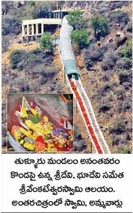
Ananthavaram has a historical temple dedicated to Lord Venkateswara, situated on the hill top. It is being administered by Tirumala Tirupati Devasthanams trust.
Transport
Ananthavaram lies on Guntur-Thulluru road. APS RTC operates bus services from Guntur, Thulluru and Velagapudi to this region.
References
Ananthavaram Wikipedia(Text) CC BY-SA