
Population 602 (2011 census) State electorate(s) LaraBuninyong Postal code 3213 | Postcode(s) 3213 Local time Thursday 7:12 AM | |
 | ||
LGA(s) City of Greater GeelongGolden Plains Shire Weather 12°C, Wind N at 11 km/h, 81% Humidity Federal divisions Division of Corangamite, Division of Corio | ||
Anakie /ænəˈkiː/ is a rural township between Geelong, Victoria, and Bacchus Marsh, Victoria, Australia. At the 2011 census, Anakie and the surrounding area had a population of 602. The town is divided between the City of Greater Geelong and Golden Plains Shire local government areas.
Contents
Map of Anakie VIC 3213, Australia
The name is believed to be derived from 'Anakie Youang', an expression in one of the local Australian Aboriginal languages, meaning 'little hill' or 'twin hills'. The nearby Brisbane Ranges National Park contains three hills known as The Anakies, as well as Mount Anakie.
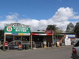
Anakie's industry consists mainly of farms and vineyards. Fairy Park, a fairytale-themed amusement park overlooking the Anakie township, is a prominent local attraction. The town is also a stopping off point for the Brisbane Ranges National Park.
The town has an Australian rules football team competing in the Geelong & District Football League.
History
The area was first settled by Europeans in 1842 when Frederick Griffin established his Anakie pastoral run. In the 1850s, Griffin subdivided some of the land along the Anakie Creek, which became a small village. A Wesleyan school opened in 1858 and a Catholic school in 1859. The Post Office opened on 15 October 1858 By 1865 the town had a hotel and a Presbyterian church. A Catholic church was established in 1871 followed by an Anglican church in 1891. The size of the farming lots were too small for most farmers to make a living, and so consolidations occurred, which resulted in a drop in population.
Residents in Anakie experienced severe bushfires on 22 January 2006 with fires spreading over 67 square kilometres (26 sq mi) of land and at least three homes being lost in conditions surpassing 42 °C (108 °F).
Narada Homestead, located at 130 Mount Road, dates from 1862 and is listed on the Victorian Heritage Register.