
Council Merom Hagalil Population (2015) 125 | Founded 1980 Local time Wednesday 9:43 AM | |
 | ||
Name meaning Named for Biblical location Weather 11°C, Wind NE at 10 km/h, 73% Humidity | ||
Amuka (Hebrew: עֲמֻקָּה) is a communal settlement near Safed in the Upper Galilee in northern Israel. It belongs to the Merom HaGalil Regional Council. It is named for the Biblical city of the same name, which is presumed to be located near the present-day settlement. In 2015 it had a population of 125.
Contents
Map of Amuka, Israel
History
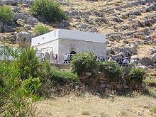
The community was founded in 1980 as part of the Galilee Lookouts program (Hebrew: תוכנית המצפים בגליל). Near the community is the burial place of Rabbi Jonathan ben Uzziel, to whom some people attribute special powers (segulot).
Education
Children in the community attend schools in nearby villages "Nof Harim" elementary school in Sasa, "Anne Frank" high school in Sasa, "Har VeGai" high school, and Einot Yarden high school.
Synagogue
There is a large ruined building above the burial place of Jonathan ben Uzziel. Its remnants are located east of the valley where the Arab village Ammuqa was located until its depopulation in 1948. In the 19th century, the researcher Geren saw there "the base of a pillar and a number of hewn stones - the remnants of an old structure, possibly a synagogue." Tzvi Ilan writes that today that some of the hewn stones are centralized in the center of the ruin like a platform for worship. West of the platform is a rectangular area of 20 by 30 meters appropriate for a synagogue. In the past there was a marble board with a figure of a grapevine.