
Country Ethiopia Official name Fasil Ghebbi Criteria ii, iii Area 204,709 km² ISO 3166 code ISO 3166-2:ET | Capital Bahir Dar Type Ethiopian architecture Designated 1979 Population 17.22 million (2007) | |
 | ||
Colleges and Universities Bahir Dar University, University of Gondar, Debre markos University Destinations Simien Mountain, Lalibela, Lake Tana, Bahir Dar, Gondar Points of interest Simien Mountains National, Lake Tana, Blue Nile Falls, Ras Dashen, Fasil Ghebbi | ||
Amhara (Amharic: አማራ?) is one of the nine ethnic divisions (kililoch) of Ethiopia, containing the homeland of the Amhara people. Previously known as Region 3, its capital is Bahir Dar. Ethiopia's largest inland body of water, Lake Tana, which is the source of the Blue Nile river, is located within Amhara. The region also contains the Semien Mountains National Park, which includes Ras Dashan, the highest point in Ethiopia. Amhara is bordered by the state of Sudan to the west and northwest, and in other directions by other regions of Ethiopia: Tigray to the north, Afar to the east, Benishangul-Gumuz to the west and southwest, and Oromia to the south.
Contents
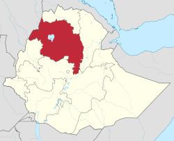
- Map of Amhara Ethiopia
- Ethiopia protests in amhara regional state continued
- Demographics
- Ethnic groups
- Water flow
- Agriculture
- Landmarks
- Presidents of the Executive Committee
- Administrative zones
- References
Map of Amhara, Ethiopia
During Ethiopia's imperial era, Amhara included several provinces (such as Dembiya, Gojjam, Begemder, Angot, Wollo, Shewa and Lasta), most of which were ruled by native Ras or Negus. The Amhara Region then incorporated most of the former provinces of Begemder, Dembiya, Angot, Bete Amhara (Wollo), Gojjam and Shewa. When the Ethiopian People's Revolutionary Democratic Front (EPRDF) took over Ethiopia, most of the Amhara Region's fertile land was taken away and incorporated to other regions like the Tigray and Benishangul-Gumuz, and lately even to the neighboring Sudan. Especially, the re-designation of Wolkayit and Tsegede in Gondar as part of Tigray Region was rejected by its residents from the beginning. This became one of the causes of the 2016 Ethiopian protests, the most violent crackdown against protesters in Sub-Saharan Africa since the Ethiopian regime killed at least 75 people during protests in the Oromia Region in November and December 2015.
Ethiopia protests in amhara regional state continued
Demographics
Based on the 2007 census conducted by the Central Statistical Agency of Ethiopia (CSA), the Amhara Region has a population of 17,221,976. 8,641,580 were men and 8,580,396 women; urban inhabitants number 2,112,595 or 12.27% of the population. With an estimated area of 159,173.66 square kilometers, this region has an estimated density of 108.2 people per square kilometer. For the entire Region 3, 983,768 households were counted, which results in an average for the Region of 4.3 persons to a household, with urban households having on average 3.3 and rural households 4.5 people.
In the previous census, conducted in 1994, the region's population was reported to be 13,834,297 of whom 6,947,546 were men and 6,886,751 women; urban inhabitants numbered 1,265,315 or 9.15% of the population.
According to the CSA, as of 2004, 28% of the total population had access to safe drinking water, of whom 19.89% were rural inhabitants and 91.8% were urban. Values for other reported common indicators of the standard of living for Amhara as of 2005 include the following: 17.5% of the inhabitants fall into the lowest wealth quintile; adult literacy for men is 54% and for women 25.1%; and the Regional infant mortality rate is 94 infant deaths per 1,000 live births, which is greater than the nationwide average of 77; at least half of these deaths occurred in the infants’ first month of life.
Ethnic groups
At 91.47% of the local population, the region is predominantly inhabited by people from the Semitic-speaking Amhara ethnic group. Most other residents hail from other Afro-Asiatic language communities, including the Agaw/Awi, Oromo, Agaw/Kamyr and Argobba.
Water flow
The Amhara Highlands receive 80% of the total rainfall of Ethiopia and is the most fertile and hospitable regions of Ethiopia. The The Amhara Region is the location of Laka Tana, the source of the Blue Nile, at Bahir Dar. The flow of the Blue Nile reaches maximum volume in the rainy season (from June to September), when it supplies about two-thirds of the water of the Nile proper. The Blue Nile, along with the Atbara River to the north, which also flows out of the Ethiopian Highlands, caused the annual Nile floods that contributed to the fertility of the Nile Valley. This supported the rise of ancient Egyptian civilization and Egyptian Mythology. With the completion in 1970 of the Aswan High Dam in Egypt, the Nile floods ended. Lake Tana has a number of islands, whose numbers vary depending on the level of the lake; it has fallen about 2 metres (6.6 ft) in the last 400 years. According to Manoel de Almeida (a Portuguese missionary in the early 17th century), there were 21 islands, seven to eight of which had monasteries on them "formerly large, but now much diminished." When James Bruce visited the area in the later 18th century, he noted that the locals counted 45 inhabited islands, but wrote he believed that "the number may be about eleven." A mid-twentieth century account identified 37 islands, of which 19 were said to have or have had monasteries or churches on them.
The lake islands were the home of ancient Ethiopian emperors. Treasures of the Ethiopian Church are kept in the isolated island monasteries (including Kebran Gabriel, Ura Kidane Mehret, Narga Selassie, Daga Estifanos, Medhane Alem of Rema, Kota Maryam and Mertola Maryam). The body of Yekuno Amlak is interred in the monastery of St. Stephen on Daga Island; other Emperors whose tombs are on Daga include Dawit I, Zara Yaqob, Za Dengel and Fasilides. Other important islands in Lake Tana include Dek, Mitraha, Gelila Zakarias, Halimun, and Briguida.
In the late 20th century, the scholar Paul B. Henze reported being shown a rock on the island of Tana Qirqos and being told it was where the Virgin Mary had rested during her journey back from Egypt. He was also told that Saint Frumentius, the bishop known for introducing Christianity to Ethiopia, was "allegedly buried on Tana Cherqos."
Agriculture
The CSA of Ethiopia estimated in 2005 that farmers in Amhara had a total of 9,694,800 head of cattle (representing 25% of Ethiopia's total cattle), 6,390,800 sheep (36.7%), 4,101,770 goats (31.6%), 257,320 horses (17%), 8,900 mules (6%), 1,400,030 asses (55.9%), 14,270 camels (3.12%), 8,442,240 poultry of all species (27.3%), and 919,450 beehives (21.1%).
Landmarks
The Amhara Region contains Ethiopia's largest inland body of water, Lake Tana, which is the source of the Blue Nile river, and the highest point in Ethiopia, Ras Dashan (4,543 m) in the Semien Mountains. UNESCO has designated the Semien Mountains National Park as part of a World Heritage Site. The mountains consist of plateaux separated by valleys and pinnacles. Other notable heights include Mounts Biuat (4,437 m) and Abba Yared (4,460 m). Most of the Amhara Region is mountainous and is covered with large trees and forest.
Endemic species of fauna include the gelada baboon, the walia ibex and the Ethiopian wolf (or Simien fox). The wide range of altitudes has given the country a variety of ecologically distinct areas, leading to the evolution of endemic species in ecological isolation.
Presidents of the Executive Committee
(This list is based on information from Worldstatesmen.org.)
Administrative zones
Like other Regions in Ethiopia, Amhara is subdivided into administrative zones.