
District Hyderabad Time zone IST (UTC+5:30) | Metro Hyderabad PIN 500 013 | |
 | ||
Government body Greater Hyderabad Municipal Corporation | ||
Lpg gas cylinder blast in amberpet 1 died 2 injured hyderabad v6 news
Amberpet is one of the oldest suburbs of Hyderabad, India. Amberpet lies adjacent to the famous Osmania University. Its area stretches from Kachiguda to Ramanthapur in the East, and from Vidyanagar to Azadnagar in the South.
Contents
- Lpg gas cylinder blast in amberpet 1 died 2 injured hyderabad v6 news
- Map of Amberpet Hyderabad Telangana
- Newly elected corporators keen focus on amberpet development activities greater leaders
- Introduction
- History
- Landmarks
- Transport
- References
Map of Amberpet, Hyderabad, Telangana
Newly elected corporators keen focus on amberpet development activities greater leaders
Introduction
Amber is an Urdu word refer to as Asmaan i.e. Sky. Although, it also has mention in the Arabic scriptures, with similar names and meaning attributed to ambergis (Perfume of Heavens). Amberpet lies adjacent to the famous Osmania University built by the then Ruler of Hyderabad, Mir Osman Ali Khan Bahadur [CBE]. Its area stretches from Kachiguda to Ramanthapur in the East, and from Vidyanagar to Azadnagar in the South. The Civil Police Lines Special Armed Reserve of the Andhra Pradesh Police Academy is situated in the midst of its sprawling campus extending from the Dargah Shareef to the inner areas of the Ranga Reddy District [District]. Amberpet was largely famous for the spread-over open markets sprouted all over the area catering to the household needs of people from all the nearby places at very affordable prices. Now, these have been replaced by many supermarkets and other allied dairy & poultry establishments.
There are many Irani cafes in the area. In the 2009 Assembly & Parliamentary Elections, Amberpet was made a separate constituency which was earlier a part of Himayathnagar constituency. There are adjoining areas also with names such as DD Colony, Bagh-Amberpet, and many more.
History
Established as a farming community on the banks of northern side of Musi river in the 18th Century, Amberpet lent its name to the famous Sufi Saint Hazrat Amber Baba, who is also believed to be one of the advisers to Mughal Emperor Aurangazeb at that time. The Dargah of Hazrat Amber baba is located right on the main road, which draws crowd from all over the place on its annual Urs. Many believe that this place, once barren, was miraculously propagated and populated into dense forest, fruit-growing fields, after Sufi Saint Amber baba made this place his final destination. Once a sub-urban area, this place has turned into a major hub for trade and Educational Institutes.
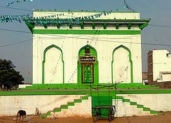
Many Masjids of Amberpet belongs to the Qutub Shahi Era and it is line up the main road leading to Warangal. Amberpet is home to second largest mosque in the city i.e. Qutub Shahi Masjid also known as Bade Masjid. Under the leadership of Syed Chand Patel, this mosque was expanded to accommodate more than 1,000 worshipers and now it is considered largest Mosque next to Makkah Masjid near Charminar in terms of worshippers. Osmania Public School was also built during the expansion of Qutub Shahi Masjid which is adjacent to the mosque
Amberpet is rich in its cultural and religious image. This place is surrounded by many temples. Sri Mahankali Temple (Amberpet Main Road), Jai Veer Hanuman Temple (Beside Sri Ramana Theatre), Sri Ram Mandir (6 no. X roads), Shivam Temple (Shivam Road) are some of the frequently visited temples by the devotees of Amberpet. All religious functions and ceremonies are celebrated in full attendance of the devotees.
Landmarks
Transport
Amberpet is well-connected by road networks and the Hyderabad-Warangal state highway passes through Amberpet. The closest railway network is of 1 km away i.e. Kachiguda railway station which is in close proximity to the Mumbai-Vijaywada national highway. The closest MMTS train station is around a kilometer away at Kachiguda or Vidyanagar.
TSRTC connects buses from various parts of the city to Amberpet. 107 and 113 bus services pass through Amberpet.