
Country France Intercommunality Boixe Area 12.1 km² | Population (2009) 317 Local time Tuesday 8:20 AM | |
 | ||
Weather 7°C, Wind SW at 27 km/h, 90% Humidity | ||
Ambérac is a French commune in the Charente département, region in the Nouvelle-Aquitaine region of southwestern France.
Contents
- Map of 16140 AmbC3A9rac France
- Geography
- Hamlets and localities
- Geology and relief
- Hydrography
- Climate
- Toponymy
- History
- Administration
- Demography
- Distribution of age groups
- Education
- Civil heritage
- Religious heritage
- Environmental heritage
- Notable people linked to the commune
- References
Map of 16140 Amb%C3%A9rac, France
The inhabitants of the commune are known as Ambéracois or Ambéracoises
Geography
Ambérac is in the north-west part of the Charente department some 24 km north by north-west of Angouleme, 6 km south-east of Aigre, and 8 kilometres north-west of Saint-Amant-de-Boixe. Access to the commune is by the D88 road from Aigre in the north-west which passes through the village and continues south-east to Xambes. The D69 road also comes from Marcillac-Lanville in the west to the village then continues east to Villognon. There are a number of hamlets in the commune apart from the village.
The nearest railway station is that of Luxé, 5 km to the north-east which is served by a TER service to Angoulême, Poitiers, and Bordeaux.
Hamlets and localities
North-west of the town along the Aume and the Route d'Aigre there are a few hamlets: les Picots, les Citres, les Marais; and some farms: le Cambouil, les Thibauds, and le Goyaud. To the east, on the road to Mansle, there is Les Granges.
Geology and relief
The commune sits on a limestone bedrock dating from the Upper Jurassic (Kimmeridgian). Alluvium dated from the Quaternary period cover the alluvial valleys of the Aume and Charente, the most recent being on the floodplain. There are also some areas of Sand on the slopes dating to the Quaternary glaciations.
The relief of the commune is that of a low plateau and a confluence of two valleys. The highest point in the commune is at an altitude of 101 m located on the western boundary. The lowest point is 46 m located along the Charente on the south-western boundary. The town was built on the banks of the river at 62 m above sea level.
Hydrography
The Charente traverses the commune downstream from Mansle and upstream from Angouleme. The village is built on the right bank and downstream of the confluence of the Aume, which flows north of the town. The Aume rises at Bouin, Deux-Sèvres, and passes through Aigre.
Climate
As in the three-quarters in the south and west of the department, the climate is oceanic Aquitaine.
Toponymy
The place was attested in the forms Amberaco from 1080 to 1117, then Ambariaco from 1274 to 1297.
It is a Gallic or Gallo-Roman toponymic form based on the suffix -acum, either from the Gallic *-AKO or the Gallo-Roman -ACU.
History
The town was inhabited as least as early as Roman times, as attested to by artifacts found in and round the commune such as a bronze likeness of Mercury wearing a winged petasos, stone slabs engraved with oculi found on the Amberac plain; a stone slab with an oculus and coins from the eras of Augustus, Marcus Aurelius, and Maximin found in the Rue du bourg. Also found in the village have been fragments of lamps, digging tools, a vase made with grey clay, other iron objects, and fragments of a mosaic.
A circular oven 1.50 m in diameter located near Granges together with pottery, tiles and bricks found in the same field date from the same period.
In a nearby location, known as 'La Tour-des-Fades, the remains of an ancient building were also discovered with rows of bricks and a vaulted gallery, the details of which are listed in La Statistique Monumentale de la Charente
Ambérac was built near the ancient city of Oliba, and was a fiefdom of the La Rochefoucauld and Marcillac families. It was an archdiocese until the Revolution.
It is mentioned for the first time as having an archpriest around 1035 for the parish of Saint-Stephen of Ambérac, a perpetual vicariate which was given by the counts of Angouleme to the Abbey of Saint-Amand de Boixe. Shortly after this founding there was an obedience in 1080. Bishop Girard II confirmed this gift in 1117 but assigned an annual fee of 5 sols, payable on the feast of Saint-Hilaire. In 1146, the prior of Lanville, who already had some rights, demanded and got upon retirement 10 sols per year in favour of the Abbey.
Since then, it has consistently remained dependent on the convent priory of Augustine de Lanville.
The village of Ville-Babou was probably built by one of the two Babou's who were Bishops of Angoulême in the 16th century.
An underground shelter was discovered in 1925.
Administration
Created as Embérac in the Canton of Lanville Marcillac in 1793, it became Ambeirac in the canton of Saint-Amand-de-Boixe in 1801 then Ambérac.
Administration
List of Successive Mayors
(Not all data is known)
Demography
In 2009 the commune had 317 inhabitants. The evolution of the number of inhabitants is known through the population censuses conducted in the commune since 1793. From the 21st century, a census of communes with fewer than 10,000 inhabitants is held every five years, unlike larger towns that have a sample survey every year.
Sources : Ldh/EHESS/Cassini until 1962, INSEE database from 1968 (population without double counting and municipal population from 2006)
Distribution of age groups
Percentage Distribution of Age Groups in Ambérac and Charente Department in 2009
Sources:
Out of a labour force of 145 people, there are 11 unemployed giving an unemployment rate of 7.6%. The average income is €11,750 per year
Education
The school is an intercommunal educational group between Ambérac and Marcillac-Lanville. Marcillac-Lanville has an elementary school and Ambérac has a primary school.
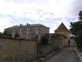
Civil heritage
Religious heritage
The Parish Church of Saint-Etienne dates from the 12th century. It was one of the 13 archpriests of Angoumois. The church contains several items that are registered as historical objects:
The church also has an Harmonium which was renovated in July 2013.
Environmental heritage
The banks of the Charente and the Aume are Natura 2000 zones.