
Gmina Alwernia Postal code 32-566 Elevation 312 m Local time Monday 12:45 PM | Time zone CET (UTC+1) Car plates KCH Area 8.87 km² Population 3,427 (30 Jun 2014) | |
 | ||
Weather 14°C, Wind SW at 10 km/h, 27% Humidity | ||
Alwernia [alˈvɛrɲa] is a Polish town situated some 36 kilometres (22 miles) west of Kraków in the Chrzanów district of the Lesser Poland Voivodeship (before 1999 it formed part of the Kraków Voivodeship). The town, as well as possessing a large chemical works, is a centre for recreation and tourism.
Contents
Map of Alwernia, Poland
History
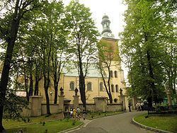
The name of the town is taken from that of the Franciscan hermitage of La Verna (Latin: Alvernia) in Tuscany, Italy. It was bestowed on the locality in 1616 by the castellan Krzysztof Koryciński. A monastery of the order of the Stigmata of Saint Francis of Assisi was built on high ground between 1625 and 1656. The church dates from the period 1630 to 1676.
Below the monastery a settlement developed which in 1776 received the right to hold a market. In 1796 Alwernia is mentioned as being a (small) commercial and administrative centre.
In 1926 a chemical works was established in the southern part of the town; today it is Alwernia's biggest employer. Its attractive setting and proximity to Kraków led to the town's growth and in 1993 Alwernia was granted full civic status.