
Elevation 1,272 m (4,173 ft) Area 2,594 km² | Time zone BRT/BRST (UTC-3/-2) | |
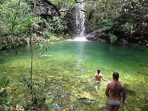 | ||
Points of interest Vale da Lua, Cachoeira de São Bento, Catarata dos Couros, Loquinhas, Pousada Fazenda São Bento | ||
Alto Paraíso de Goiás (usually referred to as Alto Paraíso) is a municipality in northeastern Goiás state, Brazil. It has become known for its ecological and New Age tourism.
Contents
- Map of Alto ParaC3ADso de GoiC3A1s State of GoiC3A1s Brazil
- Location
- Demographics
- The economy
- Tourism
- Climate
- Health and education
- History
- References
Map of Alto Para%C3%ADso de Goi%C3%A1s - State of Goi%C3%A1s, Brazil
Location
Alto Paraíso is part of the IBGE statistical micro-region of Chapada dos Veadeiros. It lies 230 km. northeast of the federal capital Brasília and 423 from the state capital Goiânia. Highway connections are made by BR-153 / Anápolis / BR-060 / Alexânia / Planaltina / GO-118 / BR-010 / São João d'Aliança.
Neighboring municipalities are:
Demographics
The economy
The economy is based on farming (soybeans (3,800 ha), corn (2000 ha), rice), cattle raising, tourism, and services. The cattle herd was 30,500 in 2006. There were two banking institutions in 2007—Banco Itaú SA and Banco do Brasil SA. (Agosto/2007). In addition these institutions, Caxia Econômica Federal (CEF) is present as well (May/2013).
Agricultural data 2006
Tourism
Located adjacent to the Chapada dos Veadeiros National Park, Alto Paraíso attracts many followers of mysticism, natural therapies, and spiritualism. The exuberant nature has mountains, canyons, waterfalls, crystal mines, and wildflowers. In the town there are more than 40 mystical, philosophical, and religious groups, transforming the town into what locals like to call The Brazilian Capital of the Third Millennium. According to believers, the fact that latitude 14, which crosses the legendary city of Machu Picchu, in Peru, also crosses Alto Paraíso, has caused appearances of flying saucers and extraterrestrials. The arrival of tourists has caused the town to have a growing infrastructure for tourism, with hotels, inns, and camping.
Climate
Temperatures in 1,300 metters (city):
→ Winter temperatures => low: 7 °C/high: 24 °C;
→ Spring temperatures => low: 13 °C/high: 28 °C;
→ Summer temperatures => low: 15 °C/high: 25 °C;
→ Autumn temperatures => low: 9 °C/high: 23 °C.
Temperatures in 1,690 metters (highest mountain):
→ Winter temperatures => low: 5 °C/high: 22 °C;
→ Spring temperatures => low: 11 °C/high: 26 °C;
→ Summer temperatures => low: 13 °C/high: 23 °C;
→ Autumn temperatures => low: 7 °C/high: 21 °C.
Alto Paraíso de Goiás, known as the coldest and highest city of Goiás (beside Cristalina - GO, which has just over 1200 meters of altitude), has a tropical mountain climate, with dry and cold in winter and warm and humid in summer. In winter, the lower temperatures can easily achieve the 5 °C and the higher ones can be under 20 °C. Normally, winter is common to have large temperature ranges. (Temperatures of a typical day of winter: min. 5 °C/máx.22 °C). There are exceptional cases where the temperatures may be less than 4 °C. (Temperatures of a typical day of autumn: min. 9 °C/máx.23 °C)
Health and education
Alto Paraíso de Goiás is in the middle position on the United Nations HDI-M with a rating of 0.738.
History
The history of Alto Paraíso goes back to the middle of the 18th century when a cattle ranch was set up by Francisco de Almeida. He called the region Veadeiros (deer). The first settlers raised cattle and wheat, due to the high altitude and colder climate. In 1938 Veadeiros appeared as a district of Cavalcante, separating in 1953 to form its own municipality. In 1963 the name was changed to Alto Paraíso de Goiás (High Paradise of Goiás).