
Admin. region Stuttgart Time zone CET/CEST (UTC+1/+2) Area 3.35 km² Local time Monday 6:32 AM Dialling code 07127 | District Esslingen Postal codes 72657 Population 1,947 (31 Dec 2008) Postal code 72657 Administrative region Stuttgart | |
 | ||
Weather -1°C, Wind S at 5 km/h, 93% Humidity | ||
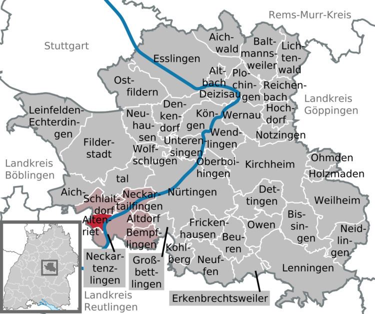
Altenriet is a municipality in the district of Esslingen in Baden-Württemberg in southern Germany.
Contents
- Map of Altenriet Germany
- Location
- Structure Outline
- Neighboring communities
- History
- Religion
- Population
- Local Businesses
- Transport
- Education
- References
Map of Altenriet, Germany
Location
Altenriet is located in a scenic area. Located in the natural area Schönbuch, Altenriet lies elevated with a steep drop towards the Neckar river and offers an unobstructed view of the Swabian Alb.
Structure / Outline
A 31 hectare uninhabited enclave belongs to Altenriet. This is four kilometers away from the center and is located in Schaichtal (valley of the Schaich river) on the mountain of the town of Walddorfhäslach.
Neighboring communities
Adjacent communities are in the North Schlaitdorf, in the East and South Neckartenzlingen (both Esslingen district) and in the West Walddorfhäslach (district Reutlingen).
History
Altenriet was originally named "Riet" in the 11th century after name of the local noble family. In the 13th century the Lord of Riet founded a castle near the site of what is today the Protestant churchyard. In the 15th century, Burg Neuenriet (New Riet Castle) was constructed outside of the village, and Burg Altenriet (Old Riet Castle), which became the village's namesake, was demolished.
When the township system was established, the village became part of the Township of Tübingen. It was transferred to the Township of Nürtingen in 1842, and became part of the District of Nürtingen when the township system was abolished by the Nazis. Finally, the village was transferred to the district of Esslingen in 1973.
Religion
Altenriet has been Protestant since the Reformation, and today the only parish in the city is Protestant. There are around 1,100 Protestants in the village, who attend services at Saint Ulrich's Church. Roman Catholics in the village are served by the parish in Neckartenzlingen.
Population
Local Businesses
In the 19th and 20th centuries, the most important parts of the economy were a sandstone quarry and a thread mill. The sandstone quarry was closed in 1936. Today there are only a few small businesses in Altenriet such as a furniture store.
Transport
Altenriet is served by intercity busline 75 (Degerloch-Bernhausen-Aich-Walddorf), bus line 188 (Nürtingen-Altdorf-Neckartenzlingen-Schlaitdorf), and bus line 189 (Neckartenzlingen-Neckartailfingen-Schlaitdorf). There 4 stops further afield of the village. The B 27 Highway, connecting Tübingen to Stuttgart, runs about 4 km away from the village through Walddorfhäslach and connects the village to Stuttgart Airport and Autobahn 8, about 20 minutes away.
Education
Altenriet has two kindergartens and one primary school. Students beyond primary school attend further education in one of the schools in Neckartenzlingen. Since 2003 there has also been a private alternative school, the "Freie Schule für lebendiges Lernen." (Free School for Spirited Study) This school complies with the educational standards of Baden-Württemberg using the Montessori method.