
 | ||
Altadena Drive is one of the major east–west roadways in Altadena, California, stretching almost continuously from one end of the town to the other. The road is actually a convergence of several smaller roads which were established over the half century of a growing Altadena community. It begins at a cul-de-sac at the Arroyo Seco, the westmost boundary of Altadena, and runs due east as West Altadena Drive to Fair Oaks Avenue, where it becomes East Altadena Drive. At Mendocino Lane it becomes North Altadena Drive, which continues into Pasadena to Colorado Boulevard, where it becomes South Altadena Drive. The road does not come to any terminus, but its name changes to Santa Anita Avenue (see history section below) and carries into San Marino.
Contents
- Map of W Altadena Dr Altadena CA 91001 USA
- The Piedmont
- East of Lake
- Santa Anita Drive
- The new Altadena Drive
- Speeding
- References
Map of W Altadena Dr, Altadena, CA 91001, USA
The Piedmont
The original name of Altadena Drive from the Arroyo Seco to Lake Avenue was Piedmont (more rurally it was called “the Piedmont”.) Piedmont is French for "foothill", but actually the Piedmont is the land which runs up from the coast to the fall line, an imaginary line drawn on a map across the first waterfalls of the rivers leading to the hills. Altadena having no waterfalls, Piedmont is an honorary name. In Altadena the Piedmont separated most of the populating areas of the Woodbury Ranch from the higher lands which developed much later. But the Piedmont became a major east–west traverse in the highlands of Altadena. The name was changed to Altadena Drive in the early 20th century, and only referred to the road that ran from the arroyo to Lake Avenue.
East of Lake
The Altadena development established by the Woodburys occurred west of Lake Avenue. But as more interest grew on the east side, more roads were developed. One was named Prospect Drive, which really had no alignment with the Piedmont, but it was close. Prospect ran from Lake Avenue to Holliston, about a half mile. Past that there was no real road development, mostly for the fact that there was no real estate development there. Prospect was aligned with Lake Avenue with a diagonal intersection to allow the traffic flow to be uninterrupted by hard turns.
In 1964 this intersection was reworked into a four-lane divided highway to accommodate higher volumes of traffic in the intersection and to further smooth the harsh turning required to negotiate the alignment.
Santa Anita Drive
In 1905 the Mount Wilson Toll Road was opened at the site of present-day Altadena Drive and Mendocino Lane. It accommodated hikers and equestrians for a nominal fee. The road became auto worthy by 1917. Access to the toll road from Pasadena was via Santa Anita Drive, which came up along the Eaton Canyon specifically for that purpose. Santa Anita Avenue was already named on the west side by the Woodburys in 1887.
Eventually the section called Prospect hooked up across the highlands to Santa Anita Drive, forming a continuous road from the Arroyo across town and down into Pasadena. This complete stretch of roadway was then named Foothill Boulevard. In 1912 the development of Altadena Country Club Park established among its roads Mendocino Lane, which intersects Altadena Drive at a point where it turns south. This becomes the divider between East Altadena Dr. and North Altadena Dr. addresses.
The new Altadena Drive
The problem arising from this naming was that an east–west Foothill Boulevard existed in East Pasadena, and the convergence of these two roads led to a confusion. In 1957 Foothill Boulevard in Altadena was renamed Altadena Drive – the whole stretch of it – all the way to Colorado Boulevard. South of Colorado, the street name became South Santa Anita Avenue, not to be confused with either the Santa Anita Avenue in Altadena, nor the one in Arcadia. Later the name Altadena Drive was extended south to Del Mar Avenue.
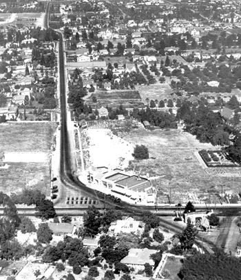
Traffic at the Lake Avenue intersection grew ever increasingly over the second half of the 20th century. The acute offset of the crossing Altadena Drive created confusion and havoc, especially for the fact that Lake Avenue has an 8% grade at that point, which gives great impetus to downhill speeds. A small spur road was created to allow traffic turning south on Lake to have a more direct route. This created a triangle in which was situated a Highland Junior restaurant (Junior’s for short). The roads virtually wrapped around the building. Prior to that was a Phillips 66 gas station.
In 1964 the County road department took a very aggressive approach in creating a smoother intersection. They acquired a couple of properties on the northwest corner, one of which was an old Richfield (of Atlantic Richfield Oil Company [ARCO]) and a few older houses, some of which had been turned into business frontages. The idea was to create a greater alignment of the thoroughfare with a smoother, rounder crossing. Second was the developing of a four-lane crossing with a center divider. This four-lane begins on the west end about 900 feet (270 m) from Lake and continues to Maiden Lane, a full block east of Lake. Then the roadway was moved north, enlarging the triangle. The spur on the south was named Fontanet Drive.
Speeding
Over the past decade complaints began being lodged against speeding along Altadena Drive. The drive was eventually surveyed and posted 35 mph (60 km/h) and radar-enforced from one end in Altadena to the other. The California Highway Patrol had written several speeding citations during the first few weeks after the posting.