
Demonym(s) Ribagorçan Largest municipality Pont de Suert | Time zone CET (UTC+1) Area 426.8 km² Population 3,873 (2014) | |
 | ||
Points of interest Aigüestortes i Estany de Sant Mau, Sant Climent - Taüll, Iglesia de Santa María de, Iglesia de San Félix, Iglesia de Santa Eulalia d Destinations Aigüestortes i Estany de Sant Mau, Vall de Boí, El Pont de Suert, Taüll, Barruera | ||
Cau art stic visita el parc de les olors de vilaller alta ribagor a lleida
Alta Ribagorça ([aɫtə riβəˈɣorsə], [ˈaɫta riβaˈɣoɾsa]) is one of the comarques of Catalonia, Spain. Its capital is Pont de Suert. The highest peak is the Comaloformo (3030 metres above sea level) in the massif of Bessiberri. Northeast of the region is the western part of the National Aiguas Tortas and Lake of San Mauricio. It is connected with the Aran valley thorough the Vielha tunnel.
Contents
- Cau art stic visita el parc de les olors de vilaller alta ribagor a lleida
- Map of LAlta RibagorC3A7a Lleida Spain
- Un passeig per vilaller alta ribagor a
- References
Map of L'Alta Ribagor%C3%A7a, Lleida, Spain
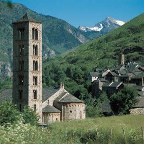
The Catalan Romanesque Churches of the Vall de Boí are UNESCO World Heritage Sites.(Nov. 30, 2000). [1]. In the North-East of the area there is the Aigüestortes i Estany de Sant Maurici National Park, which attracts an important number of visitors.
The local Ribagorçan dialect is a variant of Catalan, which has some transitional traits to Aragonese.
Location:
Highest point: Comaloformo (3030 m) in the Bessiberri Range.