
Population 304 (2011) Civil parish Alstonefield Local time Monday 12:26 AM | OS grid reference SK130555 Sovereign state United Kingdom Dialling code 01335 | |
 | ||
Weather 5°C, Wind SW at 14 km/h, 88% Humidity | ||
Alstonefield video peak district village videos
Alstonefield (alternative spelling: Alstonfield) is a village and civil parish in the Peak District National Park and the Staffordshire Moorlands district of Staffordshire, England about 7 miles (11 km) north of Ashbourne, 10 miles (16 km) east of Leek and 16 miles (26 km) south of Buxton. The parish had a population of 274 according to the 2001 census, increasing to 304 at the 2011 census.
Contents
- Alstonefield video peak district village videos
- Map of Alstonefield Ashbourne UK
- Amazing walk in alstonefield dovedale ilam 9 5 miles
- Manor Land Claim 2007
- References
Map of Alstonefield, Ashbourne, UK
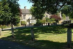
The village has two pubs; The George and The Watts Russell Arms.
Amazing walk in alstonefield dovedale ilam 9 5 miles
Manor Land Claim 2007
In 2007 Mark Roberts, a businessman involved in the Peterstone Wentloog case registered a caution against first registration for 25,000 acres (100 km2) after purchasing the Lord of the Manor of Alstonefield for £10,000 in 1999. After this case the Law Commission in England and Wales was considering abolishing feudal land law.