
Major islands Santa Bárbara Region Southeast | Total islands 5 Area 50.0 km (19.3 sq mi) Islands Isla Santa Bárbara | |
 | ||
Archipelago Arquipélago de Abrolhos | ||
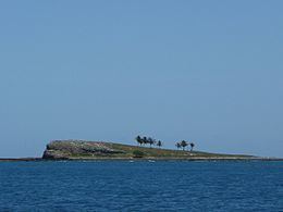
The Abrolhos Archipelago (Portuguese: Arquipélago de Abrolhos) are a group of 5 small islands with coral reefs off the southern coast of Bahia state in the northeast of Brazil, between 17º25’—18º09’ S and 38º33’—39º05’ W. Caravelas is the nearest town. Their name comes from the Portuguese: abrolho ("Abre Olhos" meaning: Open your eyes), a rock awash or submerged sandbank that is a danger to ships. There is a conspicuous shipwreck in the group.
Contents
Map of Arquip%C3%A9lago de Abrolhos, Brazil
History
These islets were surveyed by Baron Roussin. As part of the instructions for the second survey voyage of HMS Beagle, the Admiralty noted "the great importance of knowing the true position of the Abrolhos Banks, and the certainty that they extend much further out than the limits assigned to them by Baron Roussin", and asked Captain Robert FitzRoy to take soundings and establish the position of the reefs. The work was carried out from 27 to 30 March 1832, giving Charles Darwin the opportunity to examine the wildlife and geology of the islands.
Islands
Submerged banks
Wildlife
The extensive reefs of the island group are an area of rich marine fauna. The uninhabited islets are a breeding ground for pelagic birds.
The Abrolhos Marine National Park (Portuguese: Parque Nacional Marinho dos Abrolhos) is a Marine Park located in the Abrolhos Archipelago since 1983. It is strictly forbidden to disembark on Ilha Guarita and Ilha Suest.