
Elevation change 200 ft (61 m) Length 6,800 m | Lowest point Abrams Falls | |
 | ||
Trailheads Cades Cove inside of the Great Smoky Mountains National Park, off the Cades Cove Loop RoadTerminus at junction with Hannah and Hatcher Mountain Trails Use Hiking, Fishing (in the creek nearby) Highest point Junction with Hatcher and Hannah Mountain Trails Similar Great Smoky Mountains, Great Smoky Mountain, Laurel Falls Trail, Cades Cove, Roaring Fork | ||
The Abrams Falls Trail is an American hiking trail, in the Great Smoky Mountains National Park of Blount County, Tennessee. The trail runs parallel to Abrams Creek and passes Abrams Falls, one of the most voluminous waterfalls in the national park, before terminating at a junction with the Hatcher and Hannah Mountain trails.
Contents
- Map of Abrams Falls Tennessee USA
- Vital information
- Landmarksoverlooks
- Trailhead to Abrams Falls
- Abrams Falls to junction with Hannah and Hatcher Mountain trails
- Maps and Directions
- Topographic Maps
- References
Map of Abrams Falls, Tennessee, USA
Vital information
Landmarks/overlooks
Trailhead to Abrams Falls
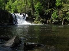
The Abrams Falls Trail begins by immediately crossing a large wooden bridge over Abrams Creek, which follows beside the trail for most of its length. Just downstream from here Mill Creek flows into and is absorbed by Abrams, and a side trail leads about a half mile to the Elijah Oliver Place, one of the best preserved housing establishments in Cades Cove, which was once home to a number of settlers before the area was bought into the Great Smoky Mountains National Park. The Abrams Falls Trail continues beyond this point gently, only taxing hikers for short periods as the trail climbs over ridges that the creek maneuvers great distances to bypass. In fact, at Arbutus Ridge, 0.8 miles (1.3 km) down the trail, the river travels over a mile whereas the hiker traverses about two footsteps over the ridge. Most of this portion of the trail follows this same framework: gentle walking near the large stream, an uphill bout over a ridge, where the trail creek turns from the trail somewhat, but never drifts too far to be heard, and a subsequent reunion as the trail dips back down the ridge from which it came, along with a few mandatory rock-hopping creek-crossings. At 2.5 miles (4.0 km), however, this ends when the trail crosses over one more waterway, Wilson Creek, and arrives at the 20-foot (6.1 m) plunge of Abrams Falls. Abrams Falls is one of the most popular destinations in the park for two reasons: its beauty and its 100-foot-wide (30 m) natural swimming pool, which is often littered with local children cooling off during the hot summer months.
Abrams Falls to junction with Hannah and Hatcher Mountain trails
This 1.7-mile (2.7 km) segment of the trail should be nearly unoccupied by other humans, as it is used rarely, at best, by hikers in the Cades Cove area. The trail here remains at the side of Abrams Creek, mounting a few more ridges and crossing over Kreider and Oak Flats Branches before arriving at a two-way junction with the Hannah and Hatcher Mountain Trails. At this juncture the hiker can choose to continue their journey either to the left at Hannah Mountain, or upon Hatcher Mountain to the right.
Maps and Directions
"Great Smoky Mountains National Park: Plan Your Visit: Abrams Falls".
"Great Smoky Mountains National Park: Maps".
Topographic Maps
The Abrams Falls Trail is shown on the following 1:24,000-scale topographic maps published by the National Park Service:
"Calderwood Quadrangle, Great Smoky Mountains 7.5 minute 1:24,000-scale series Topographic Maps." (PDF).
"Cades Cove Quadrangle, Great Smoky Mountains 7.5 minute 1:24,000-scale series Topographic Maps." (PDF).