
Country Algeria Elevation 909 m (2,982 ft) ONS code 1102 Local time Tuesday 5:51 AM Postal code 11120 | District Abalessa (coextensive) Time zone CET (UTC+01) Area 74,563 km² Population 9,163 (2008) | |
 | ||
Weather 14°C, Wind NE at 10 km/h, 18% Humidity | ||
Abalessa is a town and commune in Tamanrasset Province, in southern Algeria, coextensive with the district of the same name. According to the 2008 census it has a population of 9,163 up from 6,484 in 1998, with an annual growth rate of 3.6%. Abalessa is located along the ancient Trans-Saharan trade route, 80 kilometres (50 mi) west of the city of Tamanrasset, the capital of the province. The postcode of the town is 11120.
Contents
Map of Abalessa, Algeria
History
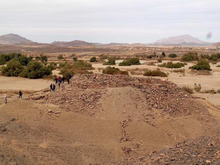
The former capital of the Ahaggar, Abalessa is famous for the Tomb of Tin Hinan, the queen and mythical ancestor of the Tuareg people. Tin Hinan supposedly arrived in the Ahaggar Mountains area and lived there in the fourth or fifth century AD. However some archeologist -like Henri Llote- think that the tomb was done on the ruins of a Roman castrum built under Augustus: this would be the southernmost presence of Roman remains in Africa.
On 18 October 1927 Byron Khun de Prorok, discovered a vault near Abalessa containing a skeleton, belonging to a woman, and her furniture. In his book Mysterious Sahara: The Land of Gold, of Sand, and of Ruin Khun de Prorok attributed the skeleton to Tin Hinan. Today, the skeleton is on display at the Bardo Museum in Algiers, while the monument where it was discovered continues to be a popular tourist attraction in Abalessa among visitors to the Tamanrasset.
Geography
The municipality reaches an average elevation of approximately 909 metres (2,982 ft) above sea level. The main town lies at an elevation of 893 metres (2,930 ft), at the confluence of the two intermittent wadis Oued Rellachene and Oued Iheri. A rocky mountain range, part of the Ahaggar Mountains rises to the west of the town reaching about 1,200 metres (3,900 ft). There is significant vegetation in the river valleys; the area belongs to the West Saharan montane xeric woodlands ecoregion.
Transportation
The N55A national highway, which branches off from the Trans-Sahara Highway (route N1) at Tit, is the main road through the area, passing just south of Abalessa.
Education
4.6% of the population has a tertiary education, and another 12.4% has completed secondary education. The overall literacy rate is 78.7%, and is 85.4% among males and 70.8% among females.
Localities
The commune is composed of eight localities: