
Basin area 324 km² Mouth elevation 0 | ||
 | ||
Municipalities Skanderborg Municipality, Aarhus Municipality | ||
The Aarhus (Danish: Aarhus Å) is a 40-kilometre (25 mi) long river or stream, in eastern Jutland, Denmark.
Contents
Map of Aarhus, Aarhus Municipality, Denmark
The Aarhus flows through the large river valley of the Aarhus Ådal. The valley itself stretches from Silkeborg to the coastal city of Aarhus, but the river runs only through the easternmost parts. The river drains a basin of 324 square kilometres (125 sq mi) in the eastern part of Søhøjlandet and discharges into the Bay of Aarhus which is an embayment of the Kattegat. It originates 54 metres (177 ft) above sea level in the swampy bogland of Astrup Mose close to Stilling-Solbjerg Lake, southwest of the city of Aarhus (56°6' northern latitude, 10°9' eastern longitude) and exits into Aarhus Harbour at 56°9' northern latitude, 10°13' eastern longitude. The river defines the border between Skanderborg and Aarhus Municipality during its first few kilometres.
History
The Aarhus river has been important for the development of the city of Aarhus since its foundation in the early Viking Age and archaeological and historical research suggests that it played a crucial role in the origins of the city.
There used to be a sizeable catch of eel, and to a lesser degree pike, in the Aarhus River up until the later part of the 20th century. Several families, often based at the rivers' watermills, made a living from it with the Brabrand Lake as the most productive fishing spot. As seen the world over, eel went into a rapid decline and with it the local fishing industry in the Aarhus River dried up. Today, after some costly efforts to restore the damaging effects of a former destructive eutrofication from nutrient pollution from household wastewater and farmland run-off, the life and ecosystems of Aarhus River is recovering and the biodiversity has broadened to include a wide range of fish species once again. Two former fish farms along the Aarhus River at Pinds Mølle and Gammel Harlev has now been re-purposed as put-and-take spots with trout for sports fishing.
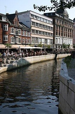
With the advance of the automobile, the rivers run through the city of Aarhus was paved over and covered by roads in the years 1930-1958. In the process, the last long stretch was named Åboulevarden and created a new transport route to the thriving industrial harbour. In 1989, it was politically decided that Aarhus River should be opened again and the project commenced in September 2005. In 2008, the reopened section of the river at Åboulevarden was inaugurated and work on the last section at the harbor front began, finishing in 2015.