
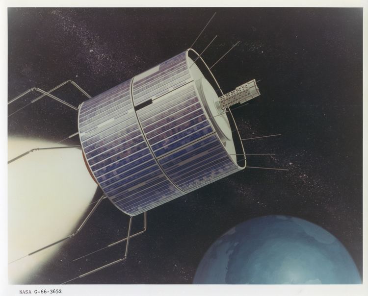
SATCAT № 3029 Bus HS-306 Inclination 6.92° Period 24 hours Rocket Atlas-Agena | COSPAR ID 1967-111A Mission duration 3 years planned Launch date 5 November 1967 Inclination 6.92° Launch mass 365 kg | |
 | ||
Mission type WeatherCommunicationsTechnology Similar ATS‑2, ATS‑4, ATS‑1, ATS‑6, WRESAT | ||
Bitter cold weather heading for alberta on monday december 2 2013
Applications Technology Satellite 3, or ATS-3, was a long-lived American experimental geostationary weather and communications satellite, operated by NASA from 1967 to 2001. It was at one time reputed to be the oldest satellite still in operation; As of 1995, NASA referred to the ATS-3 as "The oldest active communications satellite by a wide margin."
Contents
- Bitter cold weather heading for alberta on monday december 2 2013
- History
- Operational details
- References
On November 10, 1967, ATS-3 took the first color photo of the Earth, which was subsequently used on the cover of the first Whole Earth Catalog.
History
Launched in November 1967, the ATS-3 was in service for 11 years before finally being decommissioned in 1978 along with ATS-1. Among its widest-known achievements are the first full-disk, color Earth images transmitted from a satellite. Its imaging capability has served during disaster situations, from the Mexico earthquake to the Mount St. Helens eruption.
ATS-3 experiments included VHF and C-band communications, a color spin-scan camera (principally developed by Verner E. Suomi), an image dissector camera, a mechanically despun antenna, resistojet thrusters, hydrazine propulsion, optical surface experiments, and the measurement of the electron content of the ionosphere and magnetosphere.
Because of failures in the hydrogen peroxide systems on ATS-1, ATS-3 was equipped with a hydrazine propulsion system. Its success led to its incorporation on ATS-4 and ATS-5 as the sole propulsion system.
Operational details
The satellite is in geo-synchronous orbit 34,047 kilometers (21,156 mi) above the Earth's surface. The satellite has served as a communications link for rescue operations, including the 1985 Mexico City earthquake and the 1980 eruption of Mount St. Helens.
Circa 1970, ATS-3 was used to collect images of weather patterns, especially developing hurricanes in the Western Hemisphere. 1,200 line photos were downlinked, approximately every 25 minutes, during daylight hours to NOAA's Command and Data Acquisition Station at Wallops Station, Virginia and transferred to various users. The satellite was known for its spinning beam antennas locking up and rotating with the satellite. When that happened, it took a powerful ground-based transmitter, like the one at Mojave, to blast through digital instructions to get the antenna aimed back at earth again.