
Burned area 5,896 km² Location Wood Buffalo, Canada Injuries 0 | Start date May 1, 2016 Total fatalities 0 (direct); 2 (indirect) | |
 | ||
Cost $3.58 billion (insured damages)
$9.5 billion (direct and indirect costs) Land use Boreal forest, Residential, Oil Sands Buildings
destroyed 2,400
665 work camp units Locations Alberta, Wood Buffalo, Division No. 18, Saskatchewan | ||
2016 fort mcmurray wildfire disaster before and after
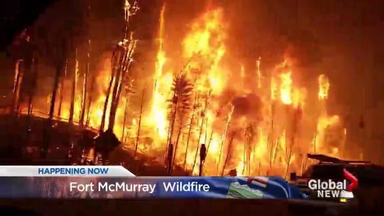
On May 1, 2016, a wildfire began southwest of Fort McMurray, Alberta, Canada. On May 3, it swept through the community, forcing the largest wildfire evacuation in Alberta's history. Personnel from the Canadian military, Royal Canadian Mounted Police, as well as firefighting forces from Alberta, other Canadian provincial agencies, and South Africa responded to the wildfire. Aid for evacuees was provided by various governments and via donations through the Canadian Red Cross and other local and national charitable organizations.
Contents
- 2016 fort mcmurray wildfire disaster before and after
- Fire progression
- Aid response
- Communities and infrastructure
- Oil sands operations
- Financial
- Cause and contributing factors
- Re entry and recovery
- References
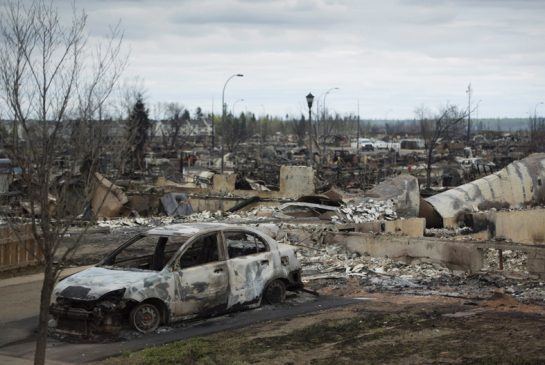
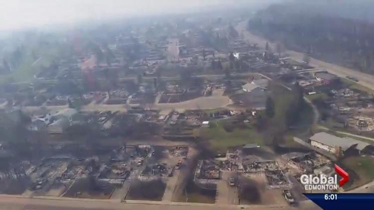
After sweeping through Fort McMurray, the wildfire destroyed approximately 2,400 homes and buildings. Another 2,000 residents in three communities were displaced after their homes were declared unsafe for reoccupation due to contamination. It continued to spread across northern Alberta and into Saskatchewan, consuming forested areas and impacting Athabasca oil sands operations. It is the costliest disaster in Canadian history.

The fire spread across approximately 590,000 hectares (1,500,000 acres) before it was declared to be under control on July 5, 2016. It continues to smoulder, and may not be fully extinguished until the spring of 2017. It is suspected to be caused by humans in a remote area 15 kilometres (9.3 mi) from Fort McMurray, but no official cause has been determined to date.
Fire progression
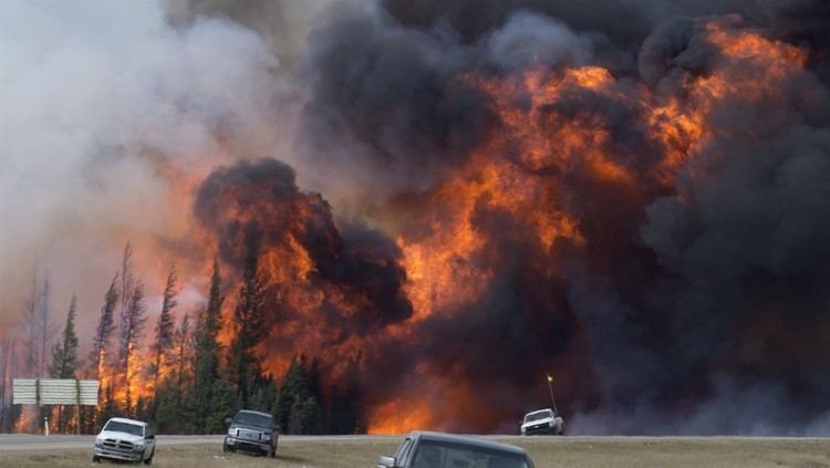
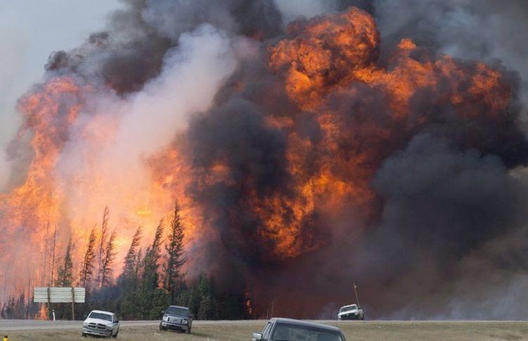
A local state of emergency was initially declared on May 1 at 9:57 p.m. MDT (03:57 UTC May 2) with the Centennial Trailer Park and the neighbourhoods of Prairie Creek and Gregoire under a mandatory evacuation. The evacuation orders for the two neighbourhoods were reduced to a voluntary stay-in-place order by the night of May 2 as the fire moved southwest and away from the area. However, the mandatory evacuation order was reinstated and expanded to 12 neighbourhoods on May 3 at 5:00 p.m. (23:00 UTC), and to the entirety of Fort McMurray by 6:49 p.m. (00:49 UTC May 4). A further order covering the nearby communities of Anzac, Gregoire Lake Estates, and Fort McMurray First Nation was issued at 9:50 p.m. on May 4 (03:50 UTC May 5). It has been reported that 88,000 people were successfully evacuated, with no reported fatalities or injuries, but two people were killed in a vehicular collision during the evacuation. Despite the mandatory evacuation order, staff at the water treatment plant remained in Fort McMurray to provide firefighters with water.
On May 4, the Regional Municipality of Wood Buffalo reported the communities of Beacon Hill, Abasand and Waterways had suffered "serious loss". The Government of Alberta declared a provincial state of emergency, and said 1,600 buildings had been destroyed by the fires. It was estimated that 10,000 hectares (25,000 acres) of land had been burned. Evacuees who travelled north of Fort McMurray were advised to stay where they were, and not to come south on Highway 63 as the fire was still burning out of control. A boil-water advisory was issued for the entire area just after 11 a.m. (17:00 UTC). At 4:05 p.m. (22:05 UTC) the fire crossed Highway 63 at Airport Road (formerly Highway 69), south of Fort McMurray, and threatened the international airport, which had suspended commercial operations earlier in the day. The fire also forced the re-location of the Regional Emergency Operations Centre, which was originally in the vicinity of the airport. On May 4, the fire was found to be producing lightning and pyrocumulus clouds due to its heat and large size, which added to the risk of more fires. The fires became large enough to create a firestorm, creating its own weather in the form of wind influxes and lightning.
The fire continued to spread south on May 5 across 85,000 hectares (210,000 acres) and forcing additional evacuations in the communities of Anzac, Gregoire Lake Estates and the Fort McMurray First Nation. These communities had accepted over 8,000 people during the initial evacuations. The Government of Alberta announced a plan to airlift approximately 8,000 of 25,000 people who had evacuated to oil sands work camps north of Fort McMurray, with assistance from a Royal Canadian Air Force Hercules aircraft, and other planes owned by energy companies operating in the oil sands. Government officials would also examine the potential for evacuations via Highway 63 during a flyover. 1,100 personnel, 45 helicopters, 138 pieces of heavy equipment and 22 air tankers were being employed to fight the fire.
On May 6, the Royal Canadian Mounted Police began leading convoys to move 1,500 vehicles from oil sand work camps north of Fort McMurray, south along Highway 63 to Edmonton. The fire continued to grow out of control, spreading to 100,000 hectares (250,000 acres) by May 6, and 156,000 hectares (390,000 acres) by May 7. As the fire grew to the northeast, the community of Fort McKay, which hosted 5,000 evacuees from Fort McMurray, was itself put under an evacuation notice. The fire was anticipated to double in size, and reach the Saskatchewan border to the east.
The wildfire continued to spread through remote forested areas in the following week, reaching oilsand work camps south of Fort MacKay, forcing the evacuation of 19 oil sites and camps with approximately 8,000 workers. One lodge with 665 units was destroyed. The fire continued to grow, from 285,000 hectares (700,000 acres) on May 16 to 504,443 hectares (1,246,510 acres) on May 21 and even spread across 741 hectares (1,830 acres) in Saskatchewan. While the fire moved away from Fort McMurray, two explosions and poor air quality continued to prevent residents and rebuilding crews from returning to the town. By May 18, the fire had grown to 423,000 hectares (1,050,000 acres) and expanded into Saskatchewan. By mid-June, rain and cooler temperatures helped firefighters contain the fire, and on July 4, 2016, the fire was declared under control. As of early 2017, the wildfire is still considered to be active, burning and smouldering in deeper layers of moss and dirt throughout the winter, and it is not expected to be extinguished until the spring.
Aid response
The Government of Alberta declared a provincial state of emergency for Fort McMurray and issued a formal request for assistance from the Canadian Armed Forces. The government and the Department of National Defence signed a memorandum of understanding on May 4, detailing required assistance and use of helicopters for rescue operations. Shortly after, a CC-130 Hercules departed CFB Trenton and helicopters were dispatched to the affected area. Alberta also requested assistance from the Government of Ontario, and Ontario committed to sending 100 firefighters and 19 supervisory staff, coordinated through the Canadian Interagency Forest Fire Centre. Other provinces across the country offered support. On May 5, four CL-415 water bombers from Quebec's SOPFEU (fr) took off from the province to aid in the firefighting effort. Royal Canadian Mounted Police coordinated and provided the bulk of the security response with assistance from both Alberta Fish and Wildlife and the Alberta Sheriffs Branch.
Australia, Israel, Mexico, the Palestinian Authority, Russia, the Republic of China, and the United States offered international assistance in battling the fire, though the offers were turned down by Prime Minister Justin Trudeau. Trudeau said that while the offers were appreciated, they were unnecessary as firefighters from other Canadian provinces were gaining control of the situation. South Africa sent 301 firefighters at the request of the Canadian Interagency Forest Fire Centre at the end of May. The firefighters were trained during the month of April at a boot camp, in order how to learn to use special hoses instead of the leather padded wooden sticks known as "firebeaters" they typically use in their home country due to a lack of water. Less than a week after being deployed the South Africans went on strike over a wage dispute and were demobilized. Alberta Premier Rachel Notley vowed to address the issue and ensure that the firefighters were paid a minimum of CA$11.20 per hour as required by the province's labour laws, rather than the CA$15 per day allowance specified in their contract with their South African employer.
The Alberta government is providing an initial $1,250 per adult and $500 per dependent to cover living expenses for those who have evacuated. On May 4, the provincial government committed to match donations made to the Canadian Red Cross, as well as to donate an additional $2 million as seed money; the federal government pledged to match all donations to the Canadian Red Cross the next day, with a deadline set to May 31. As of May 9, $54 million has been donated to the Red Cross, not including matching government contributions.
On May 4, Public Safety Canada activated the International Charter Space and Major Disasters, thus providing for the charitable and humanitarian re-tasking of the diverse satellite assets of fifteen space agencies. Later, Edmonton's Capital Region Housing Corporation (CRHC), along with the City of Edmonton, the Alberta Residential Landlord Association, and Yardi Canada Ltd., announced a partnership to create a registry of rental properties for Fort McMurray evacuees. The non-profit initiative will offer this service free of charge to landlords for the next six months. Some landlords have offered incentives to wildfire evacuees, including reduced security deposits, reduced rent, or a couple months free rent.
Prime Minister Justin Trudeau visited Fort McMurray on May 13 to survey the damage and promised ongoing aid from the federal government in the coming months. The Governor General, David Johnston, and Sophie, Countess of Wessex, met with first responders and visited the ruins of the Beacon Hill neighbourhood of Fort McMurray on June 24, 2016.
When the province of Alberta declared a state of emergency, many insurance companies invoked their emergency response plans and began mobilizing staff and resources. By May 5, insurers were on the ground at Lac La Biche, Edmonton and Calgary evacuee centres to hand out cheques for additional living expenses (ALE) and answer questions. On May 6, the Insurance Bureau of Canada (IBC) opened its Community Assistance Mobile Pavilion (CAMP) in Lac La Biche and Edmonton Northlands to provide information and answers to insurance questions. Shortly afterward, IBC's CAMP opened in Calgary.
Communities and infrastructure
Initial estimates from May 4 indicated that 1,600 structures in Fort McMurray were destroyed. Firefighters worked through May 6 and 7 to hold the line and protect the downtown and remaining homes in Fort McMurray. On May 9, this figure was revised to 2,400 structures, and about 85 to 90 percent of the community was reported undamaged. Overnight on May 16–17, two explosions occurred in the Thickwood and Dickensfield neighbourhoods, damaging ten buildings and destroying three.
The town's power grid sustained damage. Almost the entire Fort McMurray area was placed under a boil-water advisory during the fire, since untreated water was placed into the municipal water system to supply firefighters. The boil water advisory was lifted in all areas of Fort McMurray on August 17, 2016.
Statistics Canada suspended enumeration activities for the 2016 Census in the Fort McMurray area on May 5. Alternative means to collect data from its residents were to be determined at a later date. Shortly after re-entry, residents were encouraged to complete their census form online or over the phone; however door-to-door enumeration continues to be suspended.
The neighbourhoods of Waterways, Abasand, and Beacon Hill after being severely burned were then declared unsafe for reoccupation, due to contamination from arsenic and heavy metals. 2,000 residents in these neighbourhoods were only allowed supervised visits to their homes, and relied on workers from a not-for-profit organization made up of former or current Canadian and U.S. Armed Forces members to sift through leftover items. These neighbourhoods also do not have water service due to damages to the water system.
Oil sands operations
The wildfire also halted oil sands production at facilities north of Fort McMurray. Shell Canada shut down output at its Albian Sands mining operation, located approximately 70 km (43 mi) north of Fort McMurray. The company said its priority was to get employees and their families out of the region, and provide capacity at its work camp for some of the evacuees. Shell also provided its landing strip to fly employees and their families to Calgary or Edmonton and provided two teams to support firefighting efforts in the area.
Suncor Energy and Syncrude Canada also scaled back operations. Suncor's Millennium and North Steepbank mines are two of the largest and oldest oilsands mining operations in the Fort McMurray area, and Syncrude's Mildred Lake oilsands mine is located 35 km (22 mi) north of Fort McMurray. The companies have accommodated another 2,000 evacuees each at their work camps. On May 7, Syncrude shut down all site and processing operations, removing 4,800 employees from the area. A quarter of Canada's oil production, equal to approximately one million barrels of oil a day, was halted as a result of the fire. The lost output is estimated to cost the Albertan economy $70 million per day, and was a contributing factor to rises in global oil prices. The scaled back operations, along with a refinery outage in Edmonton, caused many gas stations to run out of gas throughout Western Canada.
On May 16, all 665 rooms at Blacksands Executive Lodge, a work camp, burned in the wildfire. Earlier that day, about 8,000 people were ordered out of 19 camps; about 6,000 remained. By May 17, the fire appeared to reach the Noralta Lodge, a few kilometres east of Blacksands.
Financial
Initial insurance payouts were estimated to total as much as C$9 billion if the entire community has to be rebuilt. By July 7, 2016, the Insurance Bureau of Canada (IBC) and Catastrophe Indices and Quantification Inc. (CatIQ) reported that insured damage was estimated to have reached $3.58 billion, making the wildfire the most expensive disaster in Canadian history, surpassing the 1998 ice storms in Quebec ($1.9 billion) and the 2013 Alberta floods ($1.8 billion). The 2011 Slave Lake wildfire, which destroyed one-third of the town of Slave Lake, cost approximately $750 million and was the most expensive fire-related disaster in Canadian history. The larger damage estimates are a result of Fort McMurray being 10 times the size of Slave Lake. A further estimate based on current damage estimated insurance payouts reaching as high as $4.7 billion.
Cause and contributing factors
An official cause of the fire has not been determined to date, but it is suspected to be human caused, starting in a remote area 15 kilometres (9.3 mi) from Fort McMurray.
During the start of the fire, an unusually hot, dry air mass was in place over Northern Alberta, which brought record-setting temperatures to Fort McMurray. On May 3, the temperature climbed to 32.8 °C (91 °F), accompanied by relative humidity as low as 12%. The situation intensified on May 4 when temperatures reached 31.9 °C (89 °F) and winds gusted to 72 km/h (45 mph). This significantly contributed to the fire's rapid growth. The winter preceding the fires was drier than usual, leaving a paltry snowpack, which melted quickly. Combined with the high temperatures, this created a "perfect storm" of conditions for an explosive wildfire.
Daniel Thompson, a fire research scientist with Natural Resources Canada in Edmonton, told Bloomberg News that the natural El Niño cycle led to a dry fall and winter season along with a warm spring. The weather condition affects fires in a number of regions including Indonesia and northwest United States and Canada. Similar events occurred in 1997–1998. Fire is a natural and necessary component of boreal forest ecosystems.
Controversy arose over the discussion that climate change was among the factors causing the fire, given the role that Fort McMurray plays in Alberta's oil sands industry. Some called it "insensitive" to discuss global warming during the crisis, while others have argued that the crisis made it "more important" to talk about a correlation between human-influenced climate change and wildfires. Canada's politicians and scientists both cautioned that individual fires cannot specifically be linked to climate change, but agree that it is part of a general trend of more intense wildfires.
Re-entry and recovery
On May 18, the Alberta government provisionally announced a phased re-entry of residents into Fort McMurray starting on June 1 and ending by June 15, given that a set of key conditions were met. Firstly, the wildfire no longer poses a threat and that hazardous areas can be secured; that local government can be re-established; and that essential services such as emergency services, transportation, utilities and essential businesses can be re-established, as well as the infrastructure that supports these services. Residents were allowed to re-enter Fort McMurray and surrounding communities according to a schedule broken down into residential zones.
In the wake of the wildfire impact on Fort McMurray, the Regional Municipality of Wood Buffalo created a Wildfire Recovery Plan. It establishes a clear framework and a governance structure to direct the recovery. Recovery funding was estimated to be above $4.5 billion: $615 million from federal, provincial and municipal governments; $319 million from the Canadian Red Cross; and $3.58 billion from the P&C insurance industry.