
Magnitude 7.7 Mw Areas affected Costa RicaPanama Tsunami 3 m (9.8 ft) | Depth 10 km (6.2 mi) Max. intensity IX (Violent) Date 22 April 1991 | |
 | ||
Casualties 75–87 dead 563–759 injured 9,839–10,900 displaced Similar 2012 Costa Rica earthquake, 2009 Costa Rica earthquake, 1906 Ecuador–Colombia earthquake, 1894 San Juan earthquake, 1992 Nicaragua earthquake | ||
The 1991 Costa Rica earthquake, also known as Limon earthquake or Bocas del Toro earthquake, occurred at 3:57 pm local time (21:56:51 UTC) on April 22. The epicenter of the 7.7 Mw earthquake was in Pandora, Valle La Estrella, in the Caribbean region of Limon, Costa Rica, 225 kilometres (140 mi) southeast of San José. The earthquake was the strongest recorded in Costa Rica's history, and was felt throughout the country as well as in western Panama.
Contents
DamageEdit
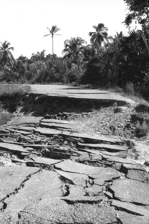
The earthquake claimed at least 48 lives in Bocas del Toro, Panama. Roads and bridges between Limon and Sixaola were all destroyed, and the epicentral region was only accessible by helicopter from the Panamaian side.
In Limon, hotels and other landmarks collapsed and 1.85 m (6 ft 1 in) of uplift at the waterfront left coral and sand bluffs exposed. In Panama, extensive damaged also occurred in Guabito, Changuinola, Almirante and Isla Colon. The Chiquita Brands office building in Changuinola separated with a 3-meter breach.
AftermathEdit
The international bridge of Sixaola stayed intact because it was well constructed by the Costa Ricans. At the Changuinola "Capitán Manuel Niño" International Airport damage on the south end of the runway was severe, and very few planes were able to land. Helicopters were the primary aircraft bringing in relief workers, food, and supplies.
By 1993, the Changuinola-Guabito road was reconstructed with $10 million USD funded by the Panamanian government, and new housing facilities were constructed in Finca 4 and Almirante. Reconstruction of the Limon-Sixaola road took months, and in 2010 the road was paved and coded as Highway 36.