
Max rating | Start date March 3, 1966 | |
 | ||
Formed March 3, 1966 4:00 p.m. – 7:45 p.m. CST Damage $17.9 million (1966 USD)$132 million (2017 USD) Casualties 58 fatalities, 518 injuries Areas affected Hinds, Rankin, Scott, Leake, Neshoba, Kemper counties in Mississippi and Pickens, Tuscaloosa counties in Alabama Similar June 1966 tornado outbreak, 1974 Super Outbreak, 1965 Palm Sunday tornado o, Tri‑State Tornado, 2011 Tuscaloosa–Birmingham tornado | ||
Survivors remember 1966 candlestick park tornado
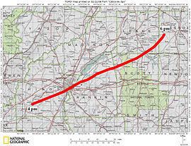
On March 3, 1966, a violent F5 tornado, dubbed the Candlestick Park tornado after the name of a Jackson, Mississippi shopping mall which was leveled by the storm, wrought catastrophic damage in Mississippi and Alabama along a 202.5 mi (325.9 km) track. The tornado first touched down in Hinds County, Mississippi around 4:00 p.m. CST and moved towards northeast before dissipating at 7:45 p.m. CST in Tuscaloosa County, Alabama.
Contents
- Survivors remember 1966 candlestick park tornado
- Meteorological synopsis
- Impact
- Historic perspective
- References

Meteorological synopsis
On March 3, 1966, the atmosphere over Mississippi was ripe for a violent tornado. In the upper-levels of the troposphere, a fairly strong jet stream, with winds estimated at 140 to 150 mph (230 to 240 km/h), oriented itself northeastward over the state, providing strong diffluence. A large mid-level trough, centered near Sioux Falls, South Dakota, was the overall system that produced the tornado. It featured low millibar heights roughly four times below the standard mean. Additionally, an unusually strong mid-level jet stream with 105 mph (169 km/h) winds provided additional energy to the storm system. The final factor in the development of the Candlestick Park storm was a subtle wind shift near the surface. At the higher levels, winds flowed from the southwest to the northeast in relation to the jet stream; however, closer to the surface, the inflow from the low pressure system over South Dakota resulted in a south to north flow, allowing for rotation within storms.

In the hours prior to the tornado forming, convective available potential energy (CAPE) values of 1554 j/kg were present, indicating significant instability. However, dry air at higher levels created a capping inversion, limiting the number of thunderstorms that could develop. Later on, a warm front moved passed Jackson, Mississippi, allowing more moist air into the region and increasing lapse rates. This cap served to prevent a tornado outbreak but allowed the formation of a few discrete strong storms. With this, a supercell thunderstorm developed over central Mississippi and produced a large tornado around 4:00 pm CST near the old Adams community in Hinds County, several miles south-southwest of Raymond.
Tracking generally to the northeast, the tornado moved through mostly rural areas, though several barns and a few homes were heavily damaged. Around 4:30 pm CST, the storm struck the southern limits of Jackson as an F4 or F5 tornado and mostly leveled the Candlestick Park shopping center. Cinder-blocks from the structure were scattered for long distances. A number of homes and businesses were also destroyed in this area. Eyewitness reported pavement scouring, and that a few cars were tossed upwards of 0.5 mi (0.80 km) by the tornado. Many homes and businesses in the area were completely destroyed by the tornado, including a glass factory that was severely mangled. A brick Baptist church was destroyed with such force that it seemingly "exploded". Once it moved through Jackson, the storm crossed the Pearl River and entered Rankin County. In Rankin County, the tornado's progress became unclear as it passed through mostly rural areas and an industrial complex. Currently, it is believed to have continued a nearly straight northeastward track through the entire county. However, reports from locals indicate that the tornado turned slightly more northward.

Near the Leesburg community, the tornado reached its maximum strength of F5, where multiple homes were swept away, large swaths of trees were leveled, pavement was scoured, and chicken houses were obliterated. Similar damage took place as the system moved into Scott County, though specifics are scarce for this portion of the storm's history. Crossing into Leake County along Mississippi Highway 35, the tornado took a more northeasterly track, passing near the communities of Madden and Salem. In Neshoba County, the storm began to weaken, though not considerably as about a dozen more homes were destroyed before the system crossed into Alabama. After crossing the border, significant damage continued through Pickens and Tuscaloosa Counties before the tornado finally dissipated near the city of Tuscaloosa around 7:45 p.m. CST. During the storm's three-hour-and-forty-five-minute existence, it traveled roughly 202.5 mi (325.9 km), one of the longest paths ever recorded.
Impact

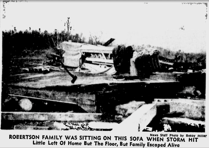
Throughout Mississippi, damage from the tornado amounted to $17.9 million (1966 USD) ($132 million (2017 USD)). The most severe damage took place at the Candlestick Park shopping center in southern Jackson where 12 people were killed. Much of the building was leveled and only one wall remained standing.
Historic perspective
Prior to the Candlestick Park tornado, there had only been one other F5 (the other occurring on December 5, 1953) to touch down in Mississippi. The next storm of this intensity would not take place until April 27, 2011, when two EF5 tornadoes touched down near the towns of Philadelphia and Smithville. Overall, the tornado ranks as the second-deadliest and longest-tracked in the state's history, having killed 57 and traveled 202.5 mi (325.9 km); however, excluding outside portions of the track, it ranks third. In general, it is also regarded as one of the most devastating tornadoes to ever strike Mississippi.
In the decades following the tornado, reassessments on the history of the storm have been made; most notably the Jackson, Mississippi branch of the National Weather Service and meteorologist Thomas P. Grazulis both indicate that there were two separate tornadoes. Based on reports from residents who experienced the tornado, a second one formed as the original dissipated, a common occurrence in cycling supercell thunderstorms. Though there is agreement on this feature, the results have not been implemented into the National Climatic Data Center's severe weather database, thus it is still officially considered one tornado. According to the study by Grazulis, the tornado dissipated over Leake County and a second tornado, estimated at F2 strength, touched down in Pickens County, Alabama. However, this leaves a gap in the track over Neshoba County where one person was killed.
On the 40th anniversary of the tornado, the National Weather Service in Jackson published a section on the tornado titled "If the Tornado Happened Today," briefly detailing the scale of damage in relation to the new developments since the tornado. Given that exactly the same tornado took place in 2006, the loss of life would be considerably higher. Striking at rush hour, numerous vehicles would be in the path of the tornado as it crossed Interstates 20 and 55 as well as U.S. Route 80. Despite vastly improved warning systems, the population density of Jackson would lean towards a higher likelihood of fatalities.