
 | ||
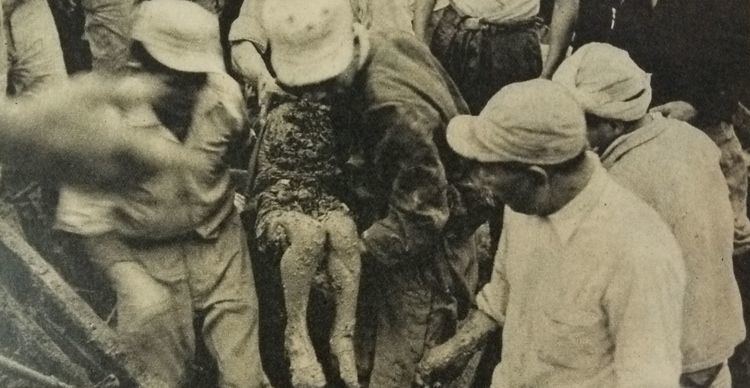
The 1953 North Kyushu flood was the flood which hit Northern Kyushu, Japan (Fukuoka Prefecture, Saga Prefecture, Kumamoto Prefecture and Ōita Prefecture) in June 1953. The torrential rain of the rainy season, amounting to more than 1,000 mm on Aso and Hikosan mountains, produced the great flood to many rivers such as Chikugo River and the toll of more than 1,000 people dead and missing. 450,000 houses were flooded and 1,000,000 people suffered from the flood. The fundamental change of flood control in the Kyushu area was needed and the standards of flood control have been taken against further floods.
Contents
Name of the flood
Weather
In the early part of June 1953, a rainy season front (baiyu zensen) stayed in the middle of Kyushu causing heavy rain, which went southward to Amami Oshima. On the other hand, a Pacific anticyclone present in the Philippines pressed the rainy season front to the Tsushima Strait. At the same time, an anticyclone from China moved to Kyushu pressing the front to Yakushima. The rainy season front was pressed both from west and south, and stayed in the Mountain Aso around June 23, and the front was stimulated by the high temperature air from the anticyclones. Low-pressure areas passed in succession from Korea and Tsushima, which usually would have stayed in Yakushima.
Shirakawa Suigai in Japanese
Flood in Fukuoka Prefecture:Chikugogawa Area
The Chikugo River (筑後川, Chikugo-gawa) flows through Kumamoto, Oita, Fukuoka and Saga prefectures in Japan. With a total length of 143 kilometres(89 mi), it is the longest river on Kyushu. It flows from Mount Aso and empties into the Ariake Sea. The river is important to industry, with twenty electrical power plants located along its banks, as well as the major city of Kurume in Fukuoka Prefecture.
Damage
The Japanese Government took appropriate measures comparable with those took for typhoons in 1948. The 5th Yoshida Cabinet (Government) placed " Nishinihon (West Japan) flood countermeasure center" in Fukuoka City. Not only National Safety Forces(which later became Land Force), but also American soldiers helped. The people in the flooded areas greatly appreciated the supply of free food and water, while they thought the flood was a natural disaster and could not be helped.
Countermeasures
1953 was the year of great disasters; the heavy rain in the south Kishu area, Wakayama Prefecture, with 1,046 people dead and missing and in the Minami Yamashiro area(105 people were killed). The causes were attributed to reckless deforestation, and the lack of water control after the second world war. The damaged Yoake Dam was investigated but the inadequate water control of the upper river was found to blame. The Japanese Government decided to follow America and its Tenessey Valley Corporation and started to build many dams such as, Matsubara Dam, Shimauch Tsutsumi (Chikugo River), Shimouke Dam (Tsue River), Ooishi, Harazuru, Sennenbunsuiro (Chikugo River), Chikugoooseki, Terauchi Dam (Sa ta River), Ishiharagawa Dam, Ooishi Dam, Jouharagawa Dam, Hyugakami Dam, Masubuchi Dam, Aburagi Dam, and Jin-ya Dam. In 2009, the countermeasures were again under review in view of the global warming and heat island phenomenon and the outbreaks of heavy rainfall in Northern Kyushu in 2009.