
First system formed June 24, 1907 Name One Total storms 5 | Last system dissipated November 12, 1907 Total depressions 5 | |
 | ||
Hurricanes 0 (record low – tied with 1914) | ||
The 1907 Atlantic hurricane season was at one point the only Atlantic hurricane season that did not feature a hurricane. With only five tropical storms having formed, it was a relatively inactive season; of those that did, three made landfall, of which all occurred on the shoreline of the Gulf Coast of the United States. The first storm of the season formed on June 24, while the final dissipated on November 12. Damage from the storms were minimal, and no deaths were reported. Due to the lack of modern technology, including satellite imagery, information is often sparse, and four additional systems could have formed during the season. A documentation for four possible storms during the season exists, although it has not been proven that these systems were fully tropical.
Contents
Background
Prior to the advent of modern tropical cyclone tracking technology, notably satellite imagery, many hurricanes that did not affect land directly went unnoticed, and storms that did affect land were not recognized until their onslaught. As a result, information on older hurricane seasons was often incomplete. Modern-day efforts have been made and are still ongoing to reconstruct the tracks of known hurricanes and to identify initially undetected storms. In many cases, the only evidence that a hurricane existed was reports from ships in its path, and judging by the direction of winds experienced by ships, and their location in relation to the storm, it is possible to roughly pinpoint the storm's center of circulation for a given point in time. This is the manner in which all of the five known storms in the 1907 season were identified by hurricane expert José Fernández-Partagás's reanalysis of hurricane seasons between 1851 and 1910. Partagás also extended the known tracks of three other hurricanes previously identified by scholars. The information Partagás and his colleague uncovered was largely adopted by the National Oceanic and Atmospheric Administration's Atlantic hurricane reanalysis in their updates to the Atlantic hurricane database (HURDAT), with some slight adjustments. HURDAT is the official source for such hurricane data as track and intensity, although due to a sparsity of available records at the time the storms existed, listings on some storms are incomplete.
The season was one of only two Atlantic seasons without a storm of hurricane intensity (winds of 75 mph (120 km/h) or higher), the other being the 1914 season. In addition, the maximum winds recorded from the first tropical storm were also the highest of the season; it also broke the record for the weakest "most intense" storm on record for an Atlantic hurricane season. Reanalysis also indicated that four additional systems could have developed during the season. No deaths occurred during the season and damage was minimal.
Tropical Storm One
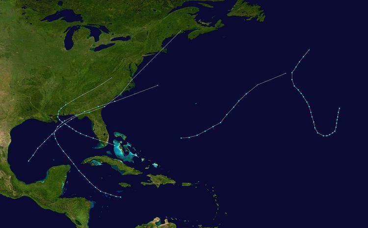
The first identified tropical storm of the season is listed in the Atlantic hurricane database as having formed on June 24, positioned in the western Caribbean Sea; the estimate for this location was based on ship reports, although the information was insufficient to guarantee an accurate position. It initially meandered west-northwestward, though began to turn northwest during the latter half of following day. Late on June 26, it passed between the Yucatán Peninsula and Cuba, and subsequently entered the Gulf of Mexico shortly thereafter. The tropical storm continued to slowly intensify, and started to make sharp curve towards the northeast on June 28.
The storm traveled east-northeastward paralleling the Gulf Coast of the United States, and eventually made landfall on the Florida panhandle early on June 29. It weakened slightly as it traversed inland, and entered the Atlantic Ocean just offshore Georgia during the morning. At this point, the storm attained its peak intensity of 65 mph (100 km/h), though it transitioned into an extratropical cyclone within the six hours that followed. Late during the day, the extratropical storm reached New Jersey, and entered Maine on June 30. The 2003 reanalysis made only minor adjustments to the storm's intensity and track created by Partagás and Diaz, which included moving the point of landfall westward and increasing windspeeds on June 29 based on readings received in Jacksonville, Florida.
Tropical Storm Two
Based on information from historical weather maps, it appeared that eastward-moving lower-atmospheric flow was present between September 16 and 17, though a closed circulation did not appear to be present. On September 18, the system developed into tropical depression between the Bahamas and Florida while it moved west-northwestward. After swiftly crossing the southern portion of the state, it strengthened into a tropical storm on September 19 over the southeastern Gulf of Mexico, and attained its peak intensity of 45 mph (75 km/h) early during September 20. It began turning north on September 21, and made landfall on the Mississippi coast on September 22. The storm weakened as it moved inland, and curved east-northeast later during that day, only to transition into an extratropical cyclone shortly thereafter. The storm lost extratropical characteristics over Virginia on September 23. As there were no reports of strong winds near the point of landfall, Partagás had doubt as to whether or not this storm was a tropical storm, as the most intense winds were recorded when the system was classified as extratropical.
Tropical Storm Three
The system that would eventually develop into a tropical storm was first noted by a ship north-northwest of Veracruz on September 23. It was recognized as a tropical storm on September 27 while was located above the Bay of Campeche, and moved northeastward, and slowly accelerated as it intensified. By September 28, it was moving east-northeastward at 24 mph (38 km/h), and simultaneously attained its peak intensity of 50 mph (85 km/h). At this point, it remained just offshore the Florida panhandle, and moved inland shortly thereafter on September 29. It plowed through northern Florida and southeastern Georgia while maintaining its intensity and transitioned into an extratropical cyclone off the coast of North Carolina on September 29. The remnants of the storm merged with a cold front the following day while situated south of New York.
Storm warnings were issued on September 28 for the shorelines of Louisiana and Mississippi, but the states did not receive strong winds. The maximum gust from the storm was 46 mph (74 km/h), which was recorded at Pensacola, Florida.
Tropical Storm Four
The fourth tropical storm of the season was first detected by a ship on October 17 southwest of Bermuda; in the HURDAT database, this date was considered to be the formation date, although the entire lifespan of the storm is unknown due to a lack of data on the system itself. It initially moved east-northeastward, though later began to turn northeastward on October 18. The storm curved slightly towards the east-northeast on October 19, and became extratropical later that day before its dissipation on October 20. The storm maintained its peak winds of 50 mph (85 km/h) for most of its lifetime.
Tropical Storm Five
The final tropical storm of the season was previously unidentified until reanalysis by Partagás. It formed on November 6 while moving south-southwestward, though took a sharp turn towards the west-southwestward on November 7. The following day, it took another sharp turn, this time towards the north-northwest, while it had winds of 45 mph (75 km/h), which were the maximum estimated winds for the storm. It continued on this path until November 11, when it turned once more, this time towards the north-northeast. It evolved into an extratropical cyclone the following day. The storm was considered to be a tropical storm based on reports of unusually warm waters near 70 °F (21 °C) which were accompanied by strong winds.