
Location Adriatic Sea Highest point Vela Straža Population 1,700 (2011) Area 58.98 km² | Highest elevation 238 m (781 ft) County Split-Dalmatia Pop. density 28 /km (73 /sq mi) | |
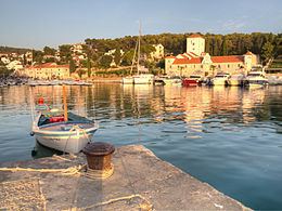 | ||
Stomorska island olta croatia new official video
Šolta ([ʃɔ̂ːlta]; Italian: Solta; Latin: Solentium) is an island in Croatia. It is situated in the Adriatic Sea in the central Dalmatian archipelago, west of the island of Brač, south of Split (separated by Split Channel) and east of the Drvenik islands, Drvenik Mali and Drvenik Veli (separated by the Šolta Channel). Its area is 58.98 km2 and it has a population of 1,700 (as of 2011).
Contents
- Stomorska island olta croatia new official video
- Map of C5A0olta Croatia
- Roga island olta croatia new official video
- Image gallery
- References
Map of %C5%A0olta, Croatia
The highest peak of Šolta is the summit Vela Straža which is 236 metres high. On the north-eastern coast of the island there are the large bays of Rogač and Nečujam. In the western part of the interior of Šolta there is a field approximately 6 km (4 mi) long and 2 km (1 mi) wide.
The economy of the island is based on vineyards, olives, fruit, fishing and tourism. While the main settlements (Grohote, Gornje Selo, Srednje Selo, Donje Selo) are inland, the main fishing centres are Maslinica, which is exposed to only north-westerly winds, making it a good shelter for smaller boats. Rogač is the main port and Nečujam the centre of the island’s tourism.