
River mouth Šventoji Length 129 km Mouth Šventoji | Basin size 918 km (354 sq mi) Basin area 918 km² | |
 | ||
Main source 9 km (5.6 mi) northeast of Paberžė Discharge Average rate:7.5 m/s (260 cu ft/s) | ||
Baidar mis irvinta 2016 05
The Širvinta is a river in Lithuania. Stretching for 129 km, it is the longest tributary of the Šventoji. Its source is in the hinterlands of the Širvintos district. After it passes through the town of Širvintos, where a low head dam has been built, it continues through the Ukmergė district, and borders the Jonava district. It ends when it flows into the Šventoji between Upninkai and Vepriai.
Contents
Map of %C5%A0irvinta, Lithuania
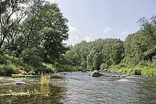
The Širvinta is distinctive for its rapid flow and winding rocky bed, which is enjoyed by kayak enthusiasts. The Širvinta Landscape Reserve, encompassing the picturesque river banks and escarpments of the Širvinta, was established in 1992 to protect the channel's unique landscape. Some of the loamy scarps near Upninkai reach as high as 40 metres.
The name of the river is probably derived from the Baltic adjective širmas/širvas, meaning brown.