
Elevation 2,038 m (6,686 ft) Highest point Mount Nasu Type of rock Volcano | Orogeny Island arc Region Tōhoku | |
 | ||
Length 500 km (310 mi) North-South Width 35 km (22 mi) East-West States ListAomori PrefectureAkita PrefectureFukushima PrefectureIwate PrefectureMiyagi PrefectureYamagata Prefecture Mountains Mt Kurikoma, Mount Hachimantai, Mount Adatara, Mount Nasu, Mt Yakeishi Similar Mount Iwate, Kitakami Mountains, Mount Zaō, Mount Hachimantai, Mount Bandai | ||
Ou sanmyaku mountains
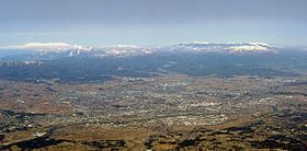
The Ōu Mountains (奥羽山脈, Ōu-sanmyaku) are a mountain range in the Tōhoku region of Honshū, Japan. The range is the longest range in Japan and stretch 500 km (311 mi) south from the Natsudomari Peninsula of Aomori Prefecture to the Nasu volcanoes at the northern boundary of the Kantō region. Though long, the range is only about 35 kilometres (22 mi) wide. The highest point in the range is Mount Iwate, 2,038 metres (6,686 ft).
Contents
- Ou sanmyaku mountains
- Map of Ou sammyaku Higashinaruse Ogachi District Akita Prefecture Japan
- Naming
- Geology
- References
Map of Ou-sammyaku, Higashinaruse, Ogachi District, Akita Prefecture, Japan
The range includes several widely known mountains: Hakkōda Mountains, Mount Iwate, Mount Zaō, Mount Azuma, and Mount Adatara.
Naming
These mountains previously formed the boundary between historical provinces of Mutsu (陸奥国) and Dewa (出羽国). The kanji for the name of the mountain range was created from one kanji of the two provinces, 奥 and 羽, respectively.
Geology
The Ōu Mountains began to form in the Pliocene. They sit over the middle of the inner arc of the Northeastern Japan Arc. This is the result of the Pacific Plate subducting under the Okhotsk Plate. A chain of Quaternary volcanoes along the range forms the volcanic front.