
Basin size 1,710 km (660 sq mi) Basin area 1,710 km² | Length 103 km | |
 | ||
Main source Mt. Kanmuri and tributaries Bridges Aioi Bridge, Ōta River Bridge Mouths Seto Inland Sea, Hiroshima Bay | ||
Ōta River (太田川, Ōta-gawa) is a 103 kilometer-(64 mile-) long river as its main stream from Mt. Kanmuri (冠山, Kanmuri-yama) (1,339m). The Ōta River is the major river that flows through Hiroshima Prefecture and empties into the Seto Inland Sea. The river descends through steep topography, with hydroelectric power plants situated along the river.
Map of Ota River, Hiroshima, Hiroshima Prefecture, Japan
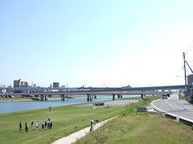
Ōta River has numerous of tributaries around the upper streams and join with Tone River and Misasa River in Asakita-ku, Hiroshima and branch into Kyōbashi River, Tenma River and Motoyasu River in the delta area of Hiroshima. Ōta River made the Hiroshima Delta. It is spanned by the Aioi Bridge, the aiming point for the Atomic bombing of Hiroshima.
Ōta River runs through Kitahiroshima, Akiota, Akitakata, Higashihiroshima and Hiroshima. The size of a catchment area is 1,710 km².