
Population 0 Area 2 ha | Highest elevation 114 m (374 ft) Elevation 114 m Archipelago Izu Islands | |
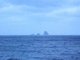 | ||
The Ōnohara Islands (大野原島, Ōnohara-jima) are a group of volcanic deserted islands located in the Philippine Sea approximately 180 kilometres (110 mi) south of Tokyo and 10 kilometres (6.2 mi) west of Miyake-jima, in the northern portion of the Izu archipelago, Japan. The group is also known as Sanbon-dake (三本岳, lit. “Three Peaks”) from its profile.
Contents
Map of Onohara-jima, Japan
Geography
Ōnohara-jima consists of nine main islets and several smaller rocks and stacks. The island is the remnant of an andesite lava dome with sheer sides, the only visible portion of a submarine volcanic caldera. The above sea-level portion has a surface area of approximately 0.2 square kilometers, with a summit height of 114 metres (374 ft) on the main islet of Koyasu-shima (小安島).
Located in the Kuroshio Current, the area has abundant sea life, and is popular with sports fishermen and scuba divers.