
- summer (DST) CEST (UTC+2) Area 5.466 km² Founded 13th century | Elevation 310 m Local time Sunday 10:14 AM | |
 | ||
Weather 15°C, Wind W at 6 km/h, 65% Humidity | ||
esk ternberk
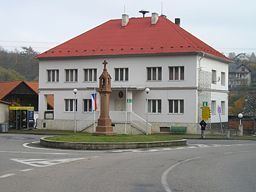
Český Šternberk (German: Böhmisch Sternberg) is a market town in the Czech Republic. Český Šternberk Castle rests on the cliffs high above the town.
Contents
- esk ternberk
- Map of 257 26 C48CeskC3BD C5A0ternberk Czechia
- Prohl dka hradu esk ternberk
- History
- Geography
- References
Map of 257 26 %C4%8Cesk%C3%BD %C5%A0ternberk, Czechia
Prohl dka hradu esk ternberk
History
The village was founded during the 13th century around Český Šternberk Castle. Along with the castle, the village expanded to its present form in 1901 and it became linked by railway. Many tourists began arriving to visit its castle.
Geography
The village is situated 310 m above sea level at the bend of the Sázava River. Neighboring communities are Čeřenice to the north, Malovidy, Zalíbená and Otryby to the east, Čejkovice and Soběšín to the southeast, Radonice to the south and Šternov and Drahňovice to the northwest.
References
Český Šternberk Wikipedia(Text) CC BY-SA