
Area 24.51 km² Local time Sunday 10:08 AM | Postal code 790 81 Elevation 399 m Population 2,487 (2012) | |
 | ||
Weather 18°C, Wind SW at 19 km/h, 40% Humidity Points of interest Zlatý Chlum, Golden Tower Chlum, Čertovy kameny ‑ skalní vyh | ||
Česká Ves (German Böhmischdorf, both meaning "Bohemian Village") is a village and municipality (obec) in Jeseník District in the Olomouc Region of the Czech Republic.
Map of %C4%8Cesk%C3%A1 Ves, Czechia
The municipality covers an area of 24.51 square kilometres (9.46 sq mi), and has a population of 2,566 (as at 3 July 2006).
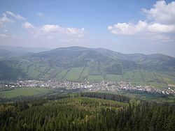
Česká Ves lies approximately 3 kilometres (2 mi) north of Jeseník, 74 km (46 mi) north of Olomouc, and 200 km (124 mi) east of Prague. It is about 13 km (8 mi) from the border with Poland.
The river Bělá flows through Česká Ves, and during the nationwide floods in 1997, the river rose up to 6 meters and half of the village was destroyed, including part of the main street, but it has now all been reconstructed.
Česká Ves lies in a small valley, surrounded by forest and hills, the highest of which is Praděd (1,492 m).
According to the Austrian census of 1910 the village had 2,434 inhabitants, 2,419 of whom had permanent residence there. Census asked people for their native language, 2,419 (100%) were German-speaking. The most populous religious group were Roman Catholics with 2,417 (99.3%).