
- summer (DST) CEST (UTC+2) Area 38.76 km² | Elevation 301 m Local time Sunday 10:06 AM | |
 | ||
Weather 12°C, Wind NW at 8 km/h, 72% Humidity Points of interest Zlatý vrch, Studený vrch, Česká Kamenice, Burg Fredevald, Muzeum psacích strojů | ||
Dobrovoln hasi i esk kamenice
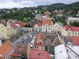
Česká Kamenice ( [ˈtʃɛskaː ˈkamɛɲɪtsɛ]; German: Böhmisch Kamnitz) is a town in Ústí nad Labem Region of the Czech Republic. It has around 5,500 inhabitants.
Contents
- Dobrovoln hasi i esk kamenice
- Map of C48CeskC3A1 Kamenice Czechia
- Tleska ky esk kamenice dance d n 2016
- The Towns Connection With Antonn Dvok
- Concentration Camp
- Notable Residents
- References
Map of %C4%8Cesk%C3%A1 Kamenice, Czechia
Following villages are administrative parts of Česká Kamenice: Pekelský Důl, Dolní Kamenice, Filipov, Huníkov, Horní Kamenice, Kamenická Nová Víska, Kerhartice and Líska.
Česká Kamenice became the Historical Town of the Year 2005.
Tleska ky esk kamenice dance d n 2016
The Town's Connection With Antonín Dvořák
Antonín Dvořák took further organ and music-theory lessons at Česká Kamenice with Franz Hanke.
Concentration Camp
In spring 1944, the Rabstejn sub-camp of Flossenburg was created here, with a capacity of 600 prisoners. At the end of the war, 1,500 inmates were incarcerated in the camp. The camp provided workers for the nearby underground aircraft factory in the town of Janská, 3 km west of Česká Kamenice. The number of inmate deaths is not known due to the destruction of all camp documentation. The foundations of camp buildings remain visible, along with a memorial and historical overview 1.