
 | ||
Similar Eiríksjökull, Tungnafellsjökull, Drangajökull, Ok, Bláfell | ||
Snowmobiling around skjaldbrei ur and risj kull
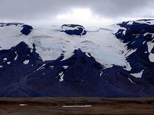
Þórisjökull or Thórisjökull (Icelandic for "Thóris's glacier") is a small glacier and volcano in western-central Iceland, to the southwest of Langjökull glacier. It has an elevation of 1,350 metres (4,430 ft). Kaldidalur lies in the foreground.
Contents
- Snowmobiling around skjaldbrei ur and risj kull
- Map of C39EC3B3risjC3B6kull Iceland
- risj kull
- PositionEdit
- The volcanoEdit
- The nameEdit
- MountaineeringEdit
- References
Map of %C3%9E%C3%B3risj%C3%B6kull, Iceland
risj kull
PositionEdit
þórisjökull is situated between Langjökull glacier and the shield volcano Ok to its east. The "Cold valley" (translation of Kaldidalur) is lying between them with its famous highland road of the same name.
The volcanoEdit
The glacier volcano Þórisjökull is a tuya from the Ice Age (in Iceland from 100,000 years ago til about 10,000 years ago). Its mountain part consists mainly of hyaloclastites. The glacier was part of Langjökull glacier probably til the end of the 18th century.
Some geological research was made again on the Þórisjökull and Prestahnúkur area in 2009 and it shows clearly active volcanic fissures under the glacier which are part of the Prestahnúkur volcanic system (see weblink, Icelandic Meteorological Institute).
The nameEdit
The name comes from the name of the troll Þóri (from Grettis Saga) which is said to have been lived in a cave nearby.
MountaineeringEdit
It is possible to hike up on the glacier from the highest point of Kaldidalur-Road near the big cairn Beinakerlingin in a height of 720 m (2,360 ft).