
Time zone CET/CEST (UTC+1/+2) Area 30.98 km² Local time Sunday 7:40 AM Dialling code 02696 | Elevation 428 m (1,404 ft) Postal codes 54579 Population 1,400 (31 Dec 2008) Postal code 54579 Municipal assoc. Hillesheim | |
 | ||
Weather 4°C, Wind NE at 3 km/h, 100% Humidity | ||
Üxheim is an Ortsgemeinde – a municipality belonging to a Verbandsgemeinde, a kind of collective municipality – in the Vulkaneifel district in Rhineland-Palatinate, Germany. It belongs to the Verbandsgemeinde of Hillesheim, whose seat is in the like-named town. The outlying centre of Niederehe is a state-recognized recreational resort (Erholungsort).
Contents
- Map of 54579 C39Cxheim Germany
- Location
- Constituent communities
- Climate
- History
- Municipal council
- Mayor
- Coat of arms
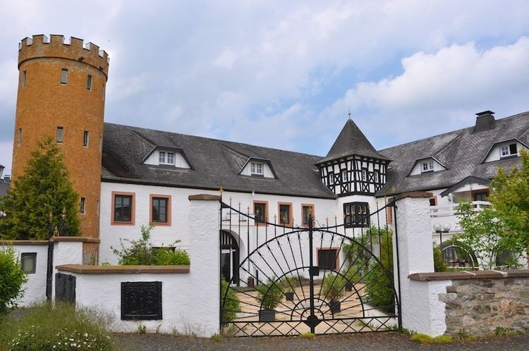
- Buildings
- Ahtte
- Flesten
- Heyroth
- Leudersdorf
- Niederehe
- Limekiln
- Dreimhlen waterfall
- References
Map of 54579 %C3%9Cxheim, Germany
Location
The municipality lies in the Vulkaneifel, a part of the Eifel known for its volcanic history, geographical and geological features, and even ongoing activity today, including gases that sometimes well up from the earth. Üxheim lies in the Hillesheimer Kalkmulde (“limestone hollow”) in the Vulkanische Westeifel, one of the three subregions into which the Vulkaneifel is divided, right on the boundary with North Rhine-Westphalia.
Constituent communities
Üxheim’s Ortsteile are Üxheim, Ahütte, Leudersdorf (with Flesten and Nollenbach), Niederehe and Heyroth. The centres of Üxheim, Ahütte and Leudersdorf with Flesten form the parish of Üxheim. These centres are known collectively in the local speech as Kijeschbel, a dialectal form of the word Kirchspiel, one of several German words for “parish”. The parish of Niederehe is made up of the centres of Kerpen with Loogh, Heyroth and Niederehe. The historically interesting convent church in Niederehe houses one of the oldest organs made by Balthasar König.
Climate
This region’s climate corresponds with the oceanic low-mountain climate.
History
In 844, Üxheim had its first documentary mention.
The municipality was newly formed on 1 January 1968 from the formerly self-administering municipalities of Leudersdorf, Niederehe and Üxheim-Ahütte. The municipality of Heyroth was amalgamated on 1 February of the same year. All these centres belonged until the end of feudal times to the Lordship of Kerpen, in the Imperially immediate ownership of the Dukes of Arenberg.
Municipal council
The council is made up of 16 council members, who were elected by proportional representation at the municipal election held on 7 June 2009, and the honorary mayor as chairman.
The municipal election held on 7 June 2009 yielded the following results:
Mayor
Üxheim’s mayor is Alois Reinarz.
Coat of arms
The German blazon reads: Unter silbernem Schildhaupt mit rotem Zickzackbalken, von Rot über Silber schräglinks geteilt, oben 4 (3:1) goldene Mispelblüten mit blauem Butzen, unten ein schwarzer Rost.
The municipality’s arms might in English heraldic language be described thus: Per bend sinister gules four cinquefoils Or pierced azure, three and one, and argent a gridiron bendwise sinister sable, on a chief of the fourth a fess dancetty of three of the first.
The municipality of Üxheim is made up of the former municipalities of Heyroth, Leudersdorf, Niederehe and Üxheim-Ahütte, all of which belonged in the Middle Ages to the Lordship of Kerpen, which was held by the Dukes of Arenberg. They bore cinquefoils (this device is so-called in English heraldry, but the German blazon describes them as Mispelblüten, German for common medlar blossoms) in the same tinctures as seen on the dexter (armsbearer’s right, viewer’s left) side below the chief in these arms. The cinquefoils here number four to stand for the municipality’s four constituent communities. The Lords of Kerpen bore arms that were “argent a fess dancetty gules” (that is, a silver shield with a horizontal zigzag red stripe), and this is recalled in the chief (the band across the top of the escutcheon). The gridiron on the sinister (armsbearer’s left, viewer’s right) side is Saint Lawrence’s attribute.
Buildings
Ahütte
Flesten
Heyroth
Leudersdorf
Niederehe
Limekiln
A restored limekiln can be found on the road from Stroheich to Nohn, about halfway between Niederehe and Nohn.
Dreimühlen waterfall
In the Ahbach valley, 1 km from Ahütte and 2.8 km from Niederehe, is the Dreimühlen (“Three Mills”) waterfall. Evaporation and consequent mineral deposition in the moss is forming calc-sinter, leading the waterfall to grow by six to eight centimetres each year. The waterfall can be reached over hiking trails, the Mineralquellen-Route and the Kalkeifel-Radweg (cycle path).