
Municipality Årdal Area 187 ha Population 3,206 (2013) | District Sogn Elevation 19 m (62 ft) Local time Sunday 6:03 AM | |
 | ||
Weather 7°C, Wind SW at 14 km/h, 97% Humidity | ||
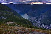
Øvre Årdal is a village in the municipality of Årdal in Sogn og Fjordane county, Norway. It is the larger of the two primary villages in Årdal. The village is situated at the northern end of the 9-kilometre (5.6 mi) long lake Årdalsvatnet, with the village of Årdalstangen at the southern end. The 1.87-square-kilometre (460-acre) village has a population (2013) of 3,206; giving the village a population density of 1,714 inhabitants per square kilometre (4,440/sq mi). Farnes Church is located in this village.
Map of 6884 %C3%98vre %C3%85rdal, Norway
The road Tindevegen goes from Øvre Årdal, through the Fardalen valley to Turtagrø in Luster municipality. It's one of the highest elevation roads in Norway. There is also a road which goes south past the lake Tyin to the European route E16 highway which goes through Valdres to Oslo.
Øvre Årdal is the starting point for tours into the nearby Utladalen Landscape Protection Area and Jotunheimen National Park. There are trips to the Utladalen and Avdalen valleys, to the mountain Falketind, to the Vettisfossen waterfall, and to the historic farms of Vetti, Vettismorki, and Avdalen.
Norsk Hydro has an aluminium smelting plant which is a major employer in the area.
Årdal FK is an association football club which plays at Jotun stadium in Øvre Årdal.