
Postal codes 38102-38104 Area 3.996 km² Dialling code 0531 | Time zone CET/CEST (UTC+1/+2) Dialling codes 0531 District Braunschweig | |
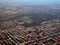 | ||
The Östliches Ringgebiet is a Stadtbezirk (city district) in the eastern part of Braunschweig, Germany. With a population of 26,723 (2015) it is the city's second most populous district.
Contents
- Map of C396stliches Ringgebiet Brunswick Germany
- History
- Politics
- Main sights
- Sports and recreation
- References
Map of %C3%96stliches Ringgebiet, Brunswick, Germany
History
Originally located outside of the city, the Östliche Ringgebiet (Eastern Ring Area) was developed as a residential area during the Gründerzeit in the late 19th century, when industrialisation caused a rapid growth of population in the city.
The centre of the district is the boulevard Jasperalle, originally Kaiser-Wilhelm-Straße, developed in 1889 by Ludwig Winter and modeled after Unter den Linden in Berlin. Lined with bourgeois townhouses, the Jasperalle connects the State Theatre in the west with the Stadtpark in the east. The name of the street was changed in 1946 to honour the social-democratic politician Heinrich Jasper, who died in 1945 in the Bergen-Belsen concentration camp.
Politics
The district mayor Uwe Jordan is a member of the Social Democratic Party of Germany.
Main sights
Sports and recreation
Two parks are located on the eastern end of the Östliche Ringgebiet, the Stadtpark and the Prinz-Albrecht-Park (short: Prinzenpark). The latter is named after Prince Albert of Prussia (German: Albrecht von Preußen), regent of the Duchy of Brunswick from 1885 to 1906.
From 1947 until 1951 the annual motorsport competition Prinzenpark-Rennen was held at a race track within the Prinz-Albrecht-Park. Prinzenparkstadion, the stadium of association football club FT Braunschweig, is also located within the park.